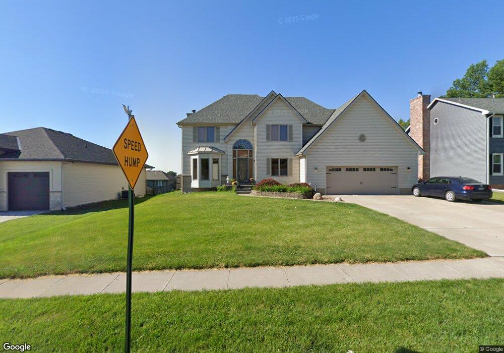
449 Brentwood Dr Gretna, NE 68028
Estimated Value: $387,980 - $436,000
4
Beds
3
Baths
2,560
Sq Ft
$161/Sq Ft
Est. Value
About This Home
This home is located at 449 Brentwood Dr, Gretna, NE 68028 and is currently estimated at $412,495, approximately $161 per square foot. 449 Brentwood Dr is a home located in Sarpy County with nearby schools including Squire John Thomas Elementary School, Gretna Middle School, and Gretna High School.
Ownership History
Date
Name
Owned For
Owner Type
Purchase Details
Closed on
Sep 11, 2019
Sold by
Detten Daniel E and Detten Sharon D
Bought by
Detten Daniel E and Detten Sharon D
Current Estimated Value
Purchase Details
Closed on
Aug 13, 2008
Sold by
Dudney Douglas D and Dudney Donna M
Bought by
Detten Daniel E and Detten Sharon D
Home Financials for this Owner
Home Financials are based on the most recent Mortgage that was taken out on this home.
Original Mortgage
$217,470
Interest Rate
6.38%
Mortgage Type
FHA
Create a Home Valuation Report for This Property
The Home Valuation Report is an in-depth analysis detailing your home's value as well as a comparison with similar homes in the area
Home Values in the Area
Average Home Value in this Area
Purchase History
| Date | Buyer | Sale Price | Title Company |
|---|---|---|---|
| Detten Daniel E | -- | None Available | |
| Detten Daniel E | $220,000 | Dakota Title & Escrow |
Source: Public Records
Mortgage History
| Date | Status | Borrower | Loan Amount |
|---|---|---|---|
| Closed | Detten Daniel E | $217,470 |
Source: Public Records
Tax History Compared to Growth
Tax History
| Year | Tax Paid | Tax Assessment Tax Assessment Total Assessment is a certain percentage of the fair market value that is determined by local assessors to be the total taxable value of land and additions on the property. | Land | Improvement |
|---|---|---|---|---|
| 2025 | $6,458 | $366,563 | $56,000 | $310,563 |
| 2024 | $6,712 | $358,564 | $54,000 | $304,564 |
| 2023 | $6,712 | $312,274 | $41,000 | $271,274 |
| 2022 | $6,602 | $289,306 | $41,000 | $248,306 |
| 2021 | $6,318 | $279,985 | $38,000 | $241,985 |
| 2020 | $5,796 | $258,369 | $35,000 | $223,369 |
| 2019 | $5,307 | $236,831 | $33,000 | $203,831 |
| 2018 | $4,866 | $218,160 | $33,000 | $185,160 |
| 2017 | $4,837 | $216,577 | $33,000 | $183,577 |
| 2016 | $4,807 | $215,821 | $30,000 | $185,821 |
| 2015 | $4,672 | $211,546 | $30,000 | $181,546 |
| 2014 | $4,653 | $212,455 | $30,000 | $182,455 |
| 2012 | -- | $216,895 | $30,000 | $186,895 |
Source: Public Records
Map
Nearby Homes
- 434 Devonshire Dr
- 19819 Sherwood Cir
- 19905 Maple St
- 22111 Hackberry Dr
- 206 E Westplains Rd
- 19910 Oak St
- 11719 S 203rd St
- 19803 Birch St
- 11280 S 200th Ave
- 20717 Frances St
- 21716 Glenmore Dr
- 21711 Glenmore Dr
- 21707 Glenmore Dr
- 11647 Willow Park Dr
- 109 Meadow Ln
- 20919 Birch St
- 347 Michael Dr
- 326 Connor St
- 419 Highland Dr
- 11512 S 191st Ave
- 445 Brentwood Dr
- 503 Brentwood Dr
- 504 Devonshire Dr
- 441 Brentwood Dr
- 508 Devonshire Dr
- 507 Brentwood Dr
- 450 Brentwood Dr
- 502 Brentwood Dr
- 446 Brentwood Dr
- 430 Devonshire Dr
- 512 Devonshire Dr
- 506 Brentwood Dr
- 437 Brentwood Dr
- 442 Brentwood Dr
- 511 Brentwood Dr
- 426 Devonshire Dr
- 516 Devonshire Dr
- 438 Brentwood Dr
- 433 Brentwood Dr
- 505 Devonshire Dr