Estimated Value: $230,030 - $257,000
3
Beds
1
Bath
1,130
Sq Ft
$214/Sq Ft
Est. Value
About This Home
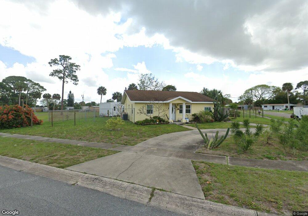
This home is located at 449 Camel Cir, Cocoa, FL 32927 and is currently estimated at $241,258, approximately $213 per square foot. 449 Camel Cir is a home located in Brevard County with nearby schools including Atlantis Elementary School, Space Coast Junior/Senior High School, and East Atlantic Prep of Brevard County.
Ownership History
Date
Name
Owned For
Owner Type
Purchase Details
Closed on
Sep 9, 2005
Sold by
Giers Mark J and Giers Michelle
Bought by
Giers Michelle
Current Estimated Value
Purchase Details
Closed on
Jul 27, 1999
Sold by
Giers Mark J
Bought by
Giers Mark J and Giers Michelle
Purchase Details
Closed on
May 19, 1995
Sold by
Bryan Richard
Bought by
Giers Mark J
Home Financials for this Owner
Home Financials are based on the most recent Mortgage that was taken out on this home.
Original Mortgage
$34,850
Interest Rate
8.35%
Purchase Details
Closed on
Sep 8, 1994
Sold by
Moses Glenn and Moses Barbara
Bought by
Bryn Richard
Create a Home Valuation Report for This Property
The Home Valuation Report is an in-depth analysis detailing your home's value as well as a comparison with similar homes in the area
Home Values in the Area
Average Home Value in this Area
Purchase History
| Date | Buyer | Sale Price | Title Company |
|---|---|---|---|
| Giers Michelle | -- | -- | |
| Giers Mark J | $17,000 | -- | |
| Giers Mark J | $41,000 | -- | |
| Bryn Richard | $42,700 | -- |
Source: Public Records
Mortgage History
| Date | Status | Borrower | Loan Amount |
|---|---|---|---|
| Previous Owner | Giers Mark J | $34,850 |
Source: Public Records
Tax History Compared to Growth
Tax History
| Year | Tax Paid | Tax Assessment Tax Assessment Total Assessment is a certain percentage of the fair market value that is determined by local assessors to be the total taxable value of land and additions on the property. | Land | Improvement |
|---|---|---|---|---|
| 2025 | $893 | $53,210 | -- | -- |
| 2024 | $875 | $51,720 | -- | -- |
| 2023 | $875 | $50,220 | $0 | $0 |
| 2022 | $832 | $48,760 | $0 | $0 |
| 2021 | $819 | $47,340 | $0 | $0 |
| 2020 | $767 | $46,690 | $0 | $0 |
| 2019 | $705 | $45,650 | $0 | $0 |
| 2018 | $696 | $44,800 | $0 | $0 |
| 2017 | $684 | $43,880 | $0 | $0 |
| 2016 | $677 | $42,980 | $18,000 | $24,980 |
| 2015 | $673 | $42,690 | $15,000 | $27,690 |
| 2014 | $673 | $42,360 | $11,000 | $31,360 |
Source: Public Records
Map
Nearby Homes
- 453 Camel Cir
- 461 Camel Cir
- 1029 Illinois Rd
- 1018 Albin St
- 973 Kaufman St
- 995 Barclay Dr
- 977 Poinsetta St
- 973 Poinsetta St
- 961 Kaufman St
- 414 Oakridge Ave
- 520 Arabella Ln
- 7000 N Highway 1 Unit 104
- 7000 N Highway 1 Unit Gg-205
- 7020 U S 1 Unit Ee-202
- 7030 N Highway 1 Unit 101
- 7030 N Highway 1 Unit DD102
- 7030 N Highway 1 Unit DD205
- 641 Lindsay Ave
- 7050 N Highway 1 Unit 106
- 7060 N Highway 1 Unit AA206