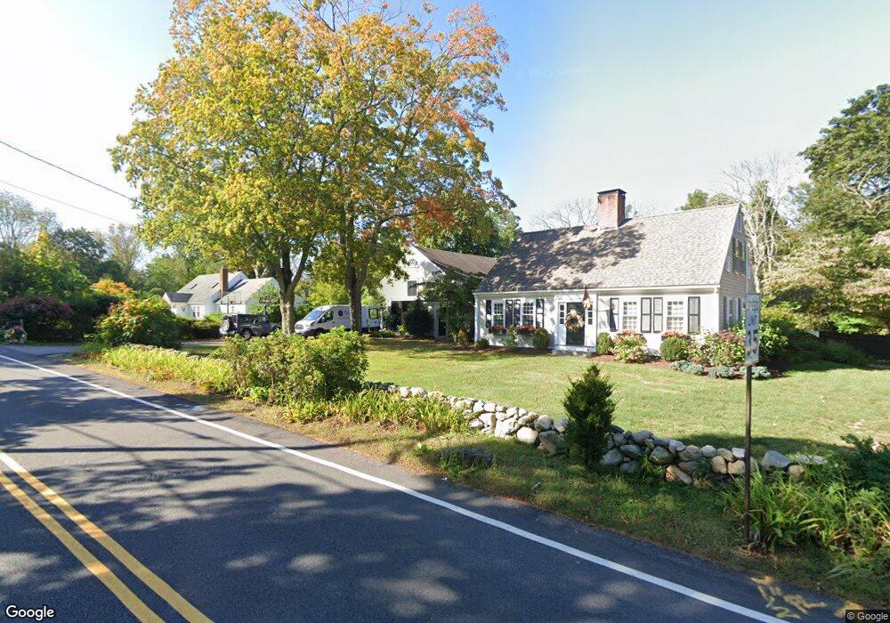
449 Country Way Scituate, MA 02066
Estimated Value: $1,099,000 - $1,249,000
3
Beds
2
Baths
2,734
Sq Ft
$424/Sq Ft
Est. Value
About This Home
This home is located at 449 Country Way, Scituate, MA 02066 and is currently estimated at $1,158,126, approximately $423 per square foot. 449 Country Way is a home located in Plymouth County with nearby schools including Cushing Elementary School, Lester J. Gates Middle School, and Scituate High School.
Ownership History
Date
Name
Owned For
Owner Type
Purchase Details
Closed on
Nov 5, 2007
Sold by
Henderson Daniel J and Henderson Karen
Bought by
Adams Christopher S and Adams Susannah
Current Estimated Value
Purchase Details
Closed on
Sep 27, 1996
Sold by
Watt Andrew R and Watt Tracey A
Bought by
Henderson Daniel J and Henderson Karen
Purchase Details
Closed on
Jun 18, 1993
Sold by
Longman Janice T
Bought by
Watt Andrew R and Watt Tracey A
Create a Home Valuation Report for This Property
The Home Valuation Report is an in-depth analysis detailing your home's value as well as a comparison with similar homes in the area
Home Values in the Area
Average Home Value in this Area
Purchase History
| Date | Buyer | Sale Price | Title Company |
|---|---|---|---|
| Adams Christopher S | $600,000 | -- | |
| Henderson Daniel J | $330,000 | -- | |
| Watt Andrew R | $310,000 | -- |
Source: Public Records
Mortgage History
| Date | Status | Borrower | Loan Amount |
|---|---|---|---|
| Open | Watt Andrew R | $212,850 | |
| Open | Watt Andrew R | $339,000 |
Source: Public Records
Tax History Compared to Growth
Tax History
| Year | Tax Paid | Tax Assessment Tax Assessment Total Assessment is a certain percentage of the fair market value that is determined by local assessors to be the total taxable value of land and additions on the property. | Land | Improvement |
|---|---|---|---|---|
| 2025 | $8,538 | $854,700 | $416,300 | $438,400 |
| 2024 | $8,689 | $838,700 | $378,500 | $460,200 |
| 2023 | $7,593 | $661,900 | $364,000 | $297,900 |
| 2022 | $7,593 | $601,700 | $336,100 | $265,600 |
| 2021 | $7,554 | $566,700 | $320,100 | $246,600 |
| 2020 | $7,479 | $554,000 | $307,800 | $246,200 |
| 2019 | $7,484 | $544,700 | $301,700 | $243,000 |
| 2018 | $7,622 | $546,400 | $287,300 | $259,100 |
| 2017 | $7,523 | $533,900 | $274,800 | $259,100 |
| 2016 | $7,196 | $508,900 | $249,800 | $259,100 |
| 2015 | $6,667 | $508,900 | $249,800 | $259,100 |
Source: Public Records
Map
Nearby Homes
- 441 Country Way
- 450 Country Way
- 457 Country Way
- 440 Country Way
- 435 Country Way
- 174 Branch St
- 166 Branch St
- 170 Branch St Unit 174
- 62 Curtis St
- 436 Country Way
- 433 Country Way
- 162 Branch St
- 156 Branch St
- 432 Country Way
- 470 Country Way
- 429 Country Way
- 58 Curtis St
- 145 Branch St
- 479 Country Way
- 466 Country Way