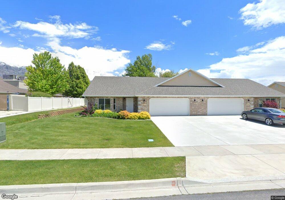
449 S 1040 E American Fork, UT 84003
Estimated Value: $406,319 - $460,000
3
Beds
2
Baths
1,374
Sq Ft
$315/Sq Ft
Est. Value
About This Home
This home is located at 449 S 1040 E, American Fork, UT 84003 and is currently estimated at $433,106, approximately $315 per square foot. 449 S 1040 E is a home located in Utah County with nearby schools including Barratt Elementary School, American Fork Junior High School, and American Fork High School.
Ownership History
Date
Name
Owned For
Owner Type
Purchase Details
Closed on
Jan 23, 2019
Sold by
Adams Polly
Bought by
The Thomas A Christian Trust
Current Estimated Value
Purchase Details
Closed on
Apr 19, 2018
Sold by
Lines Vardell
Bought by
Adams Polly
Home Financials for this Owner
Home Financials are based on the most recent Mortgage that was taken out on this home.
Original Mortgage
$275,500
Interest Rate
4.46%
Mortgage Type
New Conventional
Purchase Details
Closed on
Apr 6, 2018
Sold by
Hailes Pauline P
Bought by
Hailes Pauline P and The John M Hailes Family Trust
Home Financials for this Owner
Home Financials are based on the most recent Mortgage that was taken out on this home.
Original Mortgage
$275,500
Interest Rate
4.46%
Mortgage Type
New Conventional
Create a Home Valuation Report for This Property
The Home Valuation Report is an in-depth analysis detailing your home's value as well as a comparison with similar homes in the area
Home Values in the Area
Average Home Value in this Area
Purchase History
| Date | Buyer | Sale Price | Title Company |
|---|---|---|---|
| The Thomas A Christian Trust | -- | None Available | |
| Adams Polly | -- | North American Title Co | |
| Adams Polly | -- | North American Title | |
| Hailes Pauline P | -- | None Available |
Source: Public Records
Mortgage History
| Date | Status | Borrower | Loan Amount |
|---|---|---|---|
| Previous Owner | Adams Polly | $275,500 |
Source: Public Records
Tax History
| Year | Tax Paid | Tax Assessment Tax Assessment Total Assessment is a certain percentage of the fair market value that is determined by local assessors to be the total taxable value of land and additions on the property. | Land | Improvement |
|---|---|---|---|---|
| 2025 | $1,969 | $222,750 | -- | -- |
| 2024 | $1,969 | $218,735 | $0 | $0 |
| 2023 | $1,963 | $231,275 | $0 | $0 |
| 2022 | $1,950 | $226,655 | $0 | $0 |
| 2021 | $1,746 | $317,000 | $80,000 | $237,000 |
| 2020 | $1,698 | $299,100 | $80,000 | $219,100 |
| 2019 | $1,524 | $277,500 | $80,000 | $197,500 |
| 2018 | $1,593 | $277,500 | $80,000 | $197,500 |
| 2017 | $1,595 | $149,875 | $0 | $0 |
| 2016 | $1,555 | $135,795 | $0 | $0 |
| 2015 | $1,560 | $129,250 | $0 | $0 |
Source: Public Records
Map
Nearby Homes
- 539 S 1040 E Unit 389
- 451 S 1040 E
- 519 S 1040 E
- 513 S 1040 E
- 511 S 1040 E Unit 363
- 509 S 1040 E Unit 364
- 505 S 1040 E
- 473 S 1040 E
- 512 S 1040 E Unit 352
- 475 S 1040 E
- 1088 E 390 S Unit E
- 1088 E 390 S Unit B
- 1088 E 390 S Unit A
- 498 S 1040 E
- 496 S 1040 E Unit 347
- 492 S 1040 E
- 426 S 1040 E
- 497 S 1040 E
- 411 N 2000 W
- 422 S 1040 E
Your Personal Tour Guide
Ask me questions while you tour the home.