R
Seller's Agent in 2017
Ronnie Frost
Midland Realty


Estimated Value: $253,702
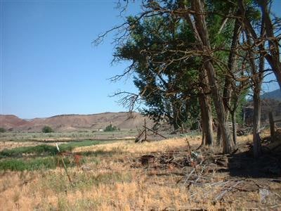
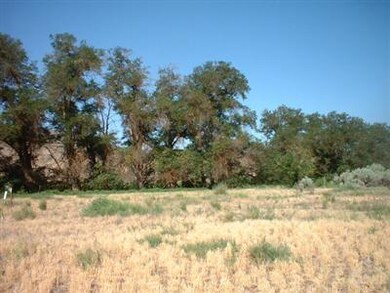
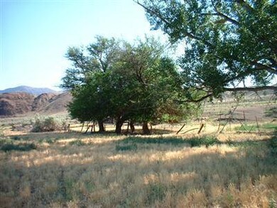
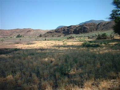
Own your own special spot on the John Day River! 1/2 mile of river frontage,+-. Large trees. Check with Wheeler County,letter on file from Wheeler Ct.planning property is buildable with certain restrictions as to river.see attached doc.#3.Buyer,buyers agent to verify details.Acreage information is from Wheeler County.Disclaimer on acreage by listing agent.
Last Agent to Sell the Property
Ronnie Frost
Midland Realty License #910100195 Listed on: 03/04/2016
Last Buyer's Agent
Gloria Kerr-Morton
Midland Realty License #890200051
| Date | Buyer | Sale Price | Title Company |
|---|---|---|---|
| Sanders Nye | -- | -- |
| Date | Event | Price | List to Sale | Price per Sq Ft |
|---|---|---|---|---|
| 04/25/2017 04/25/17 | Sold | $155,000 | -11.4% | -- |
| 08/18/2016 08/18/16 | Pending | -- | -- | -- |
| 02/24/2015 02/24/15 | For Sale | $175,000 | -- | -- |
| Year | Tax Paid | Tax Assessment Tax Assessment Total Assessment is a certain percentage of the fair market value that is determined by local assessors to be the total taxable value of land and additions on the property. | Land | Improvement |
|---|---|---|---|---|
| 2024 | $2,217 | $134,280 | $134,280 | -- |
| 2023 | $2,152 | $130,370 | $0 | $0 |
| 2022 | $1,695 | $113,030 | $0 | $0 |
| 2021 | $1,804 | $120,250 | $0 | $0 |
| 2020 | $1,899 | $126,578 | $0 | $0 |
| 2019 | $1,899 | $126,578 | $0 | $0 |
| 2018 | $1,900 | $126,445 | $0 | $0 |
| 2017 | $1,947 | $127,877 | $0 | $0 |
| 2016 | $1,947 | $64,911 | $0 | $0 |
| 2015 | $975 | $66,235 | $0 | $0 |
| 2014 | $1,862 | $124,152 | $0 | $0 |
| 2013 | $1,693 | $112,866 | $0 | $0 |
R
Seller's Agent in 2017
Ronnie Frost
Midland Realty
G
Buyer's Agent in 2017
Gloria Kerr-Morton
Midland Realty
Source: Oregon Datashare
MLS Number: 201501982
APN: 800
Disclaimer: Certain information contained herein is derived from information provided by parties other than Homes.com. All information provided is deemed reliable, but is not guaranteed to be accurate and should be independently verified.
![]() © 2025 Oregon Datashare (KCAR | MLSCO | SOMLS). All rights reserved. The data relating to real estate for sale on this web site comes in part from the Internet Data Exchange Program of the Oregon Datashare. Real estate listings held by IDX Brokerage firms other than Ten-X are marked with the Internet Data Exchange logo or the Internet Data Exchange thumbnail logo and detailed information about them includes the name of the listing Brokers. Information provided is for consumers' personal, non-commercial use and may not be used for any purpose other than to identify prospective properties the viewer may be interested in purchasing. The consumer will not copy, retransmit nor redistribute any of the content from this website. Information provided is deemed reliable, but not guaranteed.
© 2025 Oregon Datashare (KCAR | MLSCO | SOMLS). All rights reserved. The data relating to real estate for sale on this web site comes in part from the Internet Data Exchange Program of the Oregon Datashare. Real estate listings held by IDX Brokerage firms other than Ten-X are marked with the Internet Data Exchange logo or the Internet Data Exchange thumbnail logo and detailed information about them includes the name of the listing Brokers. Information provided is for consumers' personal, non-commercial use and may not be used for any purpose other than to identify prospective properties the viewer may be interested in purchasing. The consumer will not copy, retransmit nor redistribute any of the content from this website. Information provided is deemed reliable, but not guaranteed.
