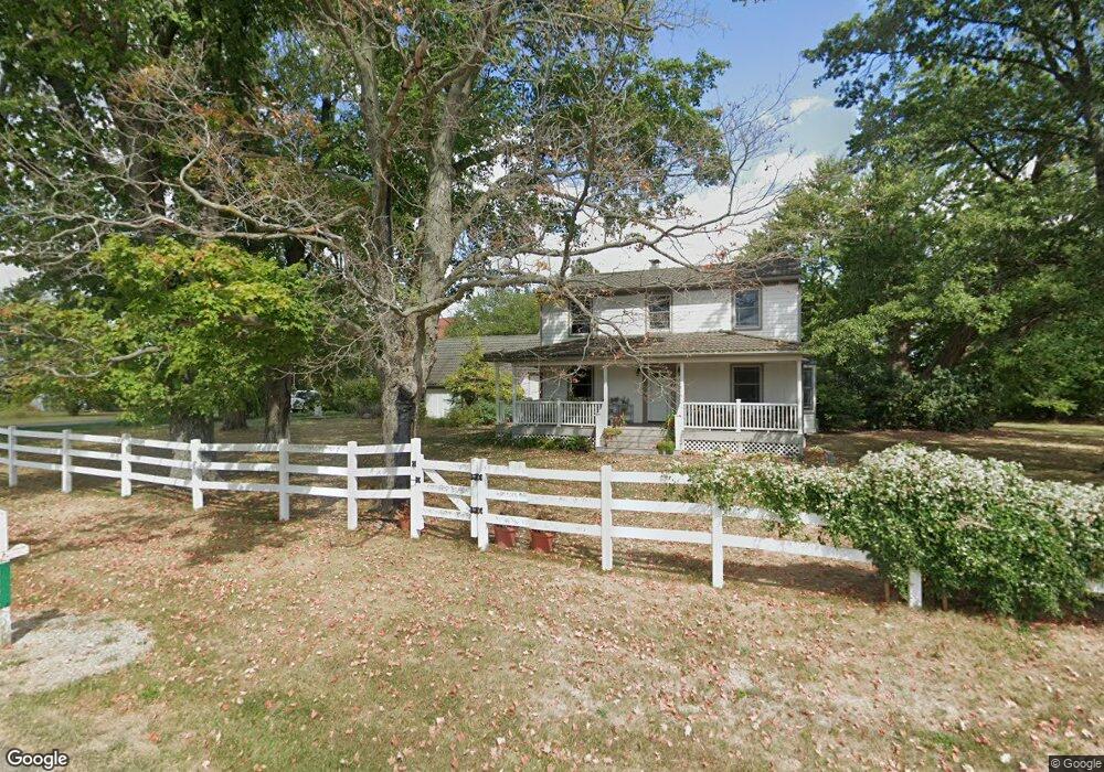
4496 N State Route 133 Blanchester, OH 45107
Estimated Value: $271,000 - $369,000
3
Beds
3
Baths
2,910
Sq Ft
$113/Sq Ft
Est. Value
About This Home
This home is located at 4496 N State Route 133, Blanchester, OH 45107 and is currently estimated at $329,115, approximately $113 per square foot. 4496 N State Route 133 is a home located in Clinton County with nearby schools including Putman Elementary School, Blanchester Middle School, and Blanchester Intermediate School.
Ownership History
Date
Name
Owned For
Owner Type
Purchase Details
Closed on
May 15, 2002
Sold by
Jacobs John B
Bought by
Pierce Frederick H and Pierce Tawny L
Current Estimated Value
Home Financials for this Owner
Home Financials are based on the most recent Mortgage that was taken out on this home.
Original Mortgage
$200,000
Outstanding Balance
$85,817
Interest Rate
7.16%
Mortgage Type
New Conventional
Estimated Equity
$243,298
Purchase Details
Closed on
Apr 26, 2002
Sold by
Jacobs John B
Bought by
Jacobs John B Shirley J
Home Financials for this Owner
Home Financials are based on the most recent Mortgage that was taken out on this home.
Original Mortgage
$200,000
Outstanding Balance
$85,817
Interest Rate
7.16%
Mortgage Type
New Conventional
Estimated Equity
$243,298
Purchase Details
Closed on
Jan 1, 1990
Bought by
Jacobs Shirley J
Create a Home Valuation Report for This Property
The Home Valuation Report is an in-depth analysis detailing your home's value as well as a comparison with similar homes in the area
Home Values in the Area
Average Home Value in this Area
Purchase History
| Date | Buyer | Sale Price | Title Company |
|---|---|---|---|
| Pierce Frederick H | $380,000 | -- | |
| Jacobs John B Shirley J | $60,000 | -- | |
| Jacobs Shirley J | -- | -- |
Source: Public Records
Mortgage History
| Date | Status | Borrower | Loan Amount |
|---|---|---|---|
| Open | Pierce Frederick H | $200,000 |
Source: Public Records
Tax History Compared to Growth
Tax History
| Year | Tax Paid | Tax Assessment Tax Assessment Total Assessment is a certain percentage of the fair market value that is determined by local assessors to be the total taxable value of land and additions on the property. | Land | Improvement |
|---|---|---|---|---|
| 2024 | $2,936 | $87,680 | $15,370 | $72,310 |
| 2023 | $2,936 | $87,680 | $15,370 | $72,310 |
| 2022 | $2,870 | $78,850 | $7,680 | $71,170 |
| 2021 | $3,026 | $78,850 | $7,680 | $71,170 |
| 2020 | $3,016 | $78,850 | $7,680 | $71,170 |
| 2019 | $2,428 | $63,090 | $7,680 | $55,410 |
| 2018 | $2,439 | $63,090 | $7,680 | $55,410 |
| 2017 | $2,382 | $63,090 | $7,680 | $55,410 |
| 2016 | $2,402 | $62,940 | $8,300 | $54,640 |
| 2015 | $2,401 | $62,940 | $8,300 | $54,640 |
| 2013 | $2,439 | $61,890 | $8,300 | $53,590 |
Source: Public Records
Map
Nearby Homes
- 450 Pansy Rd
- 582 Nauvoo Rd
- 1850 Irvin Rd
- 420 Kensington Dr
- 100ac Irvin Rd
- 4255 Nicholson Rd
- 85 Acres Templin Rd
- 10930 Henry-Plummert Rd
- 9132 St Rt 730
- 9132 State Route 730
- 279 Frances Dr
- 6748 Starkey Clevenger Rd
- 1623 Reeder Rd
- 6069 Middleboro Rd
- ac Collins-Riley Rd
- 1896 Reeder Rd
- 5 Fischer Rd
- 1727 Reeder Rd
- 217 Pansy Pike
- 9 Pansy Pike
- 4115 N St Rt 133
- 4085 N State Route 133
- 4946 N State Route 133
- 4946 N State Route 133
- 4998 N State Route 133
- 5008 N State Route 133
- 3904 St Rt 133
- 3904 N State Route 133
- 3880 N State Route 133
- 682 James Rd
- 898 James Rd
- 5 James Rd
- 4 James Rd
- 3 James Rd
- 1 James Rd
- 2 James Rd
- 784 James Rd
- 5166 N State Route 133
- 730 Sr
- 1377 James Rd