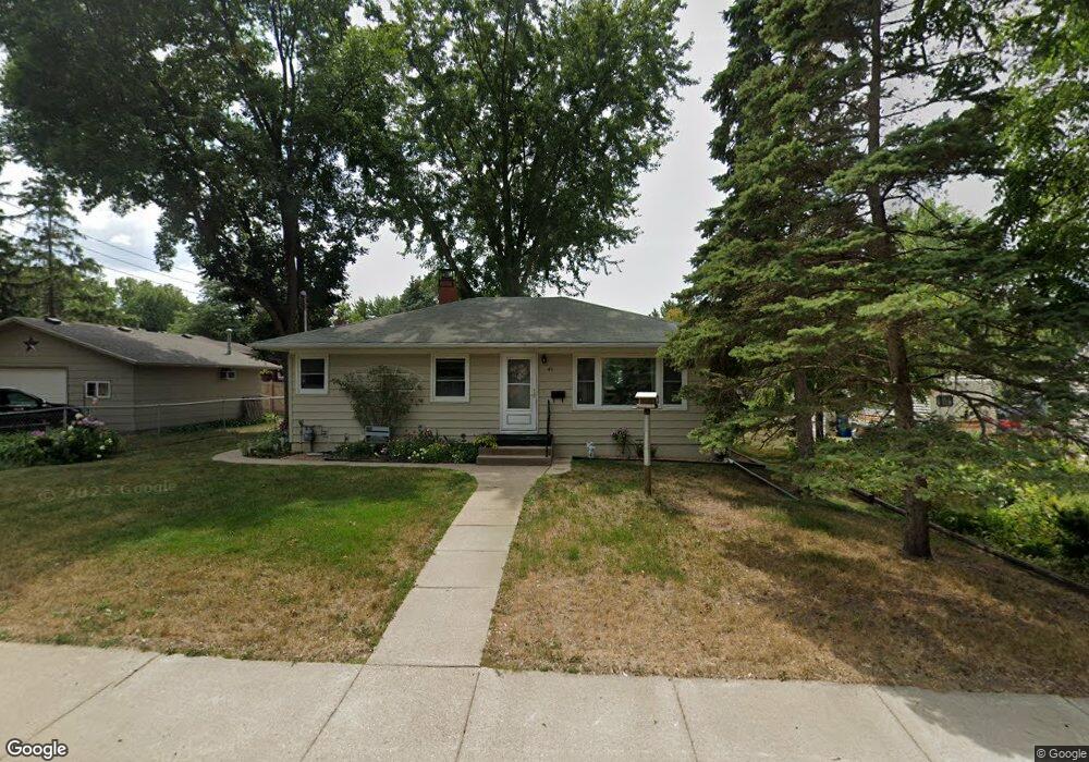
45 6th Ave S Sauk Rapids, MN 56379
Estimated Value: $211,000 - $225,000
3
Beds
1
Bath
1,064
Sq Ft
$206/Sq Ft
Est. Value
About This Home
This home is located at 45 6th Ave S, Sauk Rapids, MN 56379 and is currently estimated at $218,858, approximately $205 per square foot. 45 6th Ave S is a home located in Benton County with nearby schools including Mississippi Heights Elementary School, Sauk Rapids-Rice Middle School, and Sauk Rapids-Rice Senior High School.
Ownership History
Date
Name
Owned For
Owner Type
Purchase Details
Closed on
Nov 10, 2025
Sold by
Behrend Sarah J and Gilyard Carol L
Bought by
Dyer Dwayne and Diaz Dolores Yesenia
Current Estimated Value
Home Financials for this Owner
Home Financials are based on the most recent Mortgage that was taken out on this home.
Original Mortgage
$14,000
Outstanding Balance
$14,000
Interest Rate
6.3%
Mortgage Type
New Conventional
Estimated Equity
$204,858
Purchase Details
Closed on
May 25, 2017
Sold by
Irene Wolf
Bought by
Behrend Sarah J and Gilyard Carol L
Create a Home Valuation Report for This Property
The Home Valuation Report is an in-depth analysis detailing your home's value as well as a comparison with similar homes in the area
Home Values in the Area
Average Home Value in this Area
Purchase History
| Date | Buyer | Sale Price | Title Company |
|---|---|---|---|
| Dyer Dwayne | $227,000 | S & T Title | |
| Behrend Sarah J | $500 | None Listed On Document |
Source: Public Records
Mortgage History
| Date | Status | Borrower | Loan Amount |
|---|---|---|---|
| Open | Dyer Dwayne | $14,000 | |
| Open | Dyer Dwayne | $222,888 |
Source: Public Records
Tax History
| Year | Tax Paid | Tax Assessment Tax Assessment Total Assessment is a certain percentage of the fair market value that is determined by local assessors to be the total taxable value of land and additions on the property. | Land | Improvement |
|---|---|---|---|---|
| 2025 | $1,994 | $189,300 | $26,400 | $162,900 |
| 2024 | $1,980 | $181,100 | $26,400 | $154,700 |
| 2023 | $1,886 | $180,600 | $26,400 | $154,200 |
| 2022 | $1,674 | $160,400 | $24,000 | $136,400 |
| 2021 | $1,528 | $134,700 | $24,000 | $110,700 |
| 2018 | $1,500 | $87,200 | $17,639 | $69,561 |
| 2017 | $1,500 | $80,300 | $17,207 | $63,093 |
| 2016 | $1,480 | $114,000 | $23,100 | $90,900 |
| 2015 | $1,484 | $80,300 | $17,207 | $63,093 |
| 2014 | -- | $75,200 | $16,833 | $58,367 |
| 2013 | -- | $76,400 | $16,921 | $59,479 |
Source: Public Records
Map
Nearby Homes
- 117 6th Ave N
- 507 5th St S
- 608 Summit Ave S
- 707 2nd Ave S
- 616 2nd Ave N
- 805 2nd Ave S
- 809 Broadway Ave S
- 423 13th Ave S
- 720 3rd Ave N
- 1021 5th St S
- 445 13th Ave S
- 2021 Hillcrest Dr
- 880 Golden Spike Rd NE
- 2004 Hillcrest Dr
- 970 Golden Spike Rd NE
- 1101 Broadway Ave S
- 2007 Summit Dr
- 1715 Hillcrest Rd
- 2161 Mill Pond Dr
- TBD Golden Spike Rd
Your Personal Tour Guide
Ask me questions while you tour the home.