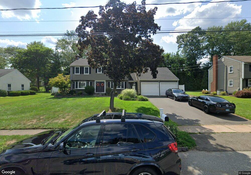
45 Black Birch Rd Wethersfield, CT 06109
Estimated Value: $599,000 - $657,927
4
Beds
4
Baths
2,255
Sq Ft
$279/Sq Ft
Est. Value
About This Home
This home is located at 45 Black Birch Rd, Wethersfield, CT 06109 and is currently estimated at $629,232, approximately $279 per square foot. 45 Black Birch Rd is a home located in Hartford County with nearby schools including Samuel B. Webb Elementary School, Woodcrest Elementary School, and Silas Deane Middle School.
Ownership History
Date
Name
Owned For
Owner Type
Purchase Details
Closed on
Sep 23, 2024
Sold by
Bartone Michael
Bought by
Bartone Jamie J
Current Estimated Value
Purchase Details
Closed on
May 19, 2003
Sold by
Caurich Ann Marie
Bought by
Bartone Michael P and Bartone Jamie J
Create a Home Valuation Report for This Property
The Home Valuation Report is an in-depth analysis detailing your home's value as well as a comparison with similar homes in the area
Home Values in the Area
Average Home Value in this Area
Purchase History
| Date | Buyer | Sale Price | Title Company |
|---|---|---|---|
| Bartone Jamie J | -- | None Available | |
| Bartone Jamie J | -- | None Available | |
| Bartone Michael P | $310,000 | -- | |
| Bartone Michael P | $310,000 | -- |
Source: Public Records
Mortgage History
| Date | Status | Borrower | Loan Amount |
|---|---|---|---|
| Previous Owner | Bartone Michael P | $253,000 | |
| Previous Owner | Bartone Michael P | $277,875 | |
| Previous Owner | Bartone Michael P | $50,000 |
Source: Public Records
Tax History Compared to Growth
Tax History
| Year | Tax Paid | Tax Assessment Tax Assessment Total Assessment is a certain percentage of the fair market value that is determined by local assessors to be the total taxable value of land and additions on the property. | Land | Improvement |
|---|---|---|---|---|
| 2025 | $15,727 | $381,530 | $104,540 | $276,990 |
| 2024 | $10,811 | $250,140 | $85,550 | $164,590 |
| 2023 | $10,451 | $250,140 | $85,550 | $164,590 |
| 2022 | $10,276 | $250,140 | $85,550 | $164,590 |
| 2021 | $10,173 | $250,140 | $85,550 | $164,590 |
| 2020 | $10,555 | $259,390 | $85,550 | $173,840 |
| 2019 | $10,191 | $250,140 | $85,550 | $164,590 |
| 2018 | $9,004 | $220,800 | $78,200 | $142,600 |
| 2017 | $8,781 | $220,800 | $78,200 | $142,600 |
| 2016 | $8,510 | $220,800 | $78,200 | $142,600 |
| 2015 | $8,432 | $220,800 | $78,200 | $142,600 |
| 2014 | $8,112 | $220,800 | $78,200 | $142,600 |
Source: Public Records
Map
Nearby Homes
- 76 Luca Lane Homesite 8
- 61 Luca Ln
- 8 Stella Dr
- 67 Luca (Homesite 6) Ln
- 53 Luca (Homesite 4) Ln
- 122 Cottonwood Rd Unit 122
- 6 Vinnie Dr
- 39 Cottonwood Rd Unit 39
- 155 Cottonwood Rd
- 5 Robeth Ln
- 0 Collier Rd
- 98 Crown Ridge
- 20 Mulberry Ct
- 17 Mulberry Ct
- 6 Barrington Dr Unit B
- 7 Barrington Dr Unit C
- 5 Barrington Dr Unit D
- 274 Cedarwood Ln
- 15 Woodsedge Dr Unit 6C
- 15 Woodsedge Dr Unit 4B
- 55 Black Birch Rd
- 39 Black Birch Rd
- 134 Back Ln
- 126 Back Ln
- 142 Back Ln
- 63 Black Birch Rd
- 31 Black Birch Rd
- 44 Black Birch Rd
- 52 Black Birch Rd
- 34 Black Birch Rd
- 118 Back Ln
- 150 Back Ln
- 60 Black Birch Rd
- 69 Black Birch Rd
- 23 Black Birch Rd
- 26 Black Birch Rd
- 68 Black Birch Rd
- 110 Back Ln
- 158 Back Ln
- 107 Apple Hill