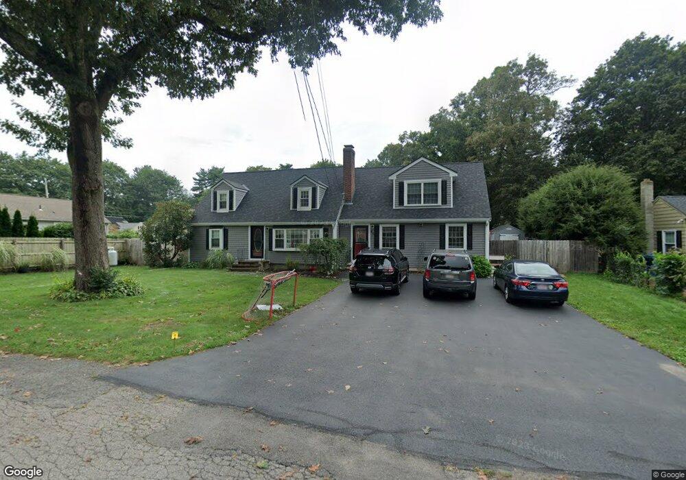
45 Circle Dr Wrentham, MA 02093
Estimated Value: $666,000 - $826,000
4
Beds
2
Baths
1,876
Sq Ft
$397/Sq Ft
Est. Value
About This Home
This home is located at 45 Circle Dr, Wrentham, MA 02093 and is currently estimated at $744,891, approximately $397 per square foot. 45 Circle Dr is a home located in Norfolk County with nearby schools including Delaney Elementary School, Charles E Roderick, and Discovery Daycare Center.
Ownership History
Date
Name
Owned For
Owner Type
Purchase Details
Closed on
Dec 10, 2020
Sold by
Foley Kathleen
Bought by
Bianculli Joseph and Bianculli Colleen T
Current Estimated Value
Home Financials for this Owner
Home Financials are based on the most recent Mortgage that was taken out on this home.
Original Mortgage
$317,000
Outstanding Balance
$280,147
Interest Rate
2.8%
Mortgage Type
New Conventional
Estimated Equity
$464,744
Purchase Details
Closed on
Jun 24, 2008
Sold by
Bianculli Colleen T and Bianculli Joseph
Bought by
Bianculli Colleen T and Bianculli Joseph
Purchase Details
Closed on
Sep 28, 2001
Sold by
Young Richard A and Young Maryann V
Bought by
Bianculli Joseph and Bianculli Colleen T
Create a Home Valuation Report for This Property
The Home Valuation Report is an in-depth analysis detailing your home's value as well as a comparison with similar homes in the area
Purchase History
| Date | Buyer | Sale Price | Title Company |
|---|---|---|---|
| Bianculli Joseph | -- | None Available | |
| Bianculli Colleen T | -- | -- | |
| Bianculli Colleen T | -- | -- | |
| Bianculli Joseph | $249,250 | -- | |
| Bianculli Joseph | $249,250 | -- |
Source: Public Records
Mortgage History
| Date | Status | Borrower | Loan Amount |
|---|---|---|---|
| Open | Bianculli Joseph | $317,000 | |
| Previous Owner | Bianculli Joseph | $373,836 | |
| Previous Owner | Bianculli Joseph | $369,713 |
Source: Public Records
Tax History
| Year | Tax Paid | Tax Assessment Tax Assessment Total Assessment is a certain percentage of the fair market value that is determined by local assessors to be the total taxable value of land and additions on the property. | Land | Improvement |
|---|---|---|---|---|
| 2025 | $7,187 | $620,100 | $260,400 | $359,700 |
| 2024 | $7,014 | $584,500 | $260,400 | $324,100 |
| 2023 | $6,965 | $551,900 | $236,700 | $315,200 |
| 2022 | $6,607 | $483,300 | $220,800 | $262,500 |
| 2021 | $6,229 | $442,700 | $192,800 | $249,900 |
| 2020 | $6,233 | $437,400 | $171,400 | $266,000 |
| 2019 | $5,990 | $424,200 | $171,400 | $252,800 |
| 2018 | $6,018 | $422,600 | $171,600 | $251,000 |
| 2017 | $5,599 | $392,900 | $168,200 | $224,700 |
| 2016 | $5,481 | $383,800 | $163,400 | $220,400 |
| 2015 | $5,288 | $353,000 | $157,100 | $195,900 |
| 2014 | $5,202 | $339,800 | $151,100 | $188,700 |
Source: Public Records
Map
Nearby Homes
- 10 Nature View Dr
- 15 Nature View Dr
- 500 Franklin St
- 2 Earle Stewart Ln
- 3 Earle Stewart Ln
- 12 Earle Stewart Ln
- 10 Earle Stewart Ln Unit Lot 5
- 287 Park St
- 246 Forest Grove Ave
- 576 Dedham St
- 11 Weber Farm Rd Unit 11
- 8 Weber Farm Rd Unit 8
- 50 Reed Fulton Ave Unit Lot 61
- 30 Weber Farm Rd Unit 30
- 0 W Birch Rd
- 45 Joshua Rd
- 8 Ridgefield Rd
- 9 Sharon Ave
- 11 Sharon Ave
- 25 Foxboro Rd
Your Personal Tour Guide
Ask me questions while you tour the home.