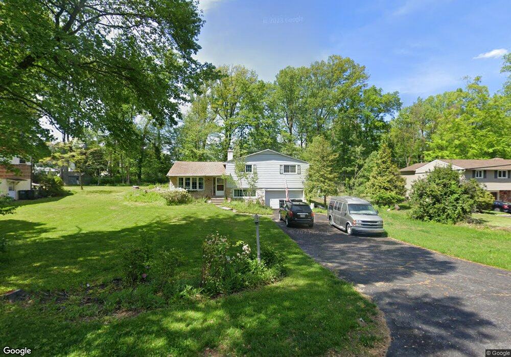
45 Heron Rd Southampton, PA 18966
Estimated Value: $537,000 - $616,000
3
Beds
2
Baths
1,600
Sq Ft
$356/Sq Ft
Est. Value
About This Home
This home is located at 45 Heron Rd, Southampton, PA 18966 and is currently estimated at $570,037, approximately $356 per square foot. 45 Heron Rd is a home located in Bucks County with nearby schools including Holland Elementary School, Holland Middle School, and Council Rock High School - South.
Ownership History
Date
Name
Owned For
Owner Type
Purchase Details
Closed on
Aug 1, 2025
Sold by
Sheriff Of Bucks County
Bought by
Morgan Stanley Abs Capital I Inc Trust and Deutsche Bank National Trust
Current Estimated Value
Purchase Details
Closed on
Nov 23, 2005
Sold by
Bareis Aurea C
Bought by
Taggart Kenneth
Home Financials for this Owner
Home Financials are based on the most recent Mortgage that was taken out on this home.
Original Mortgage
$50,200
Interest Rate
5.86%
Mortgage Type
Credit Line Revolving
Purchase Details
Closed on
Jun 11, 1957
Bought by
Bareis Fredk L and Bareis Aurea C
Create a Home Valuation Report for This Property
The Home Valuation Report is an in-depth analysis detailing your home's value as well as a comparison with similar homes in the area
Home Values in the Area
Average Home Value in this Area
Purchase History
| Date | Buyer | Sale Price | Title Company |
|---|---|---|---|
| Morgan Stanley Abs Capital I Inc Trust | $1,332 | None Listed On Document | |
| Taggart Kenneth | $334,900 | None Available | |
| Bareis Fredk L | -- | -- |
Source: Public Records
Mortgage History
| Date | Status | Borrower | Loan Amount |
|---|---|---|---|
| Previous Owner | Taggart Kenneth | $50,200 | |
| Previous Owner | Taggart Kenneth | $267,900 |
Source: Public Records
Tax History Compared to Growth
Tax History
| Year | Tax Paid | Tax Assessment Tax Assessment Total Assessment is a certain percentage of the fair market value that is determined by local assessors to be the total taxable value of land and additions on the property. | Land | Improvement |
|---|---|---|---|---|
| 2025 | $5,008 | $26,000 | $6,120 | $19,880 |
| 2024 | $5,008 | $26,000 | $6,120 | $19,880 |
| 2023 | $4,720 | $26,000 | $6,120 | $19,880 |
| 2022 | $4,677 | $26,000 | $6,120 | $19,880 |
| 2021 | $4,529 | $26,000 | $6,120 | $19,880 |
| 2020 | $4,427 | $26,000 | $6,120 | $19,880 |
| 2019 | $4,237 | $26,000 | $6,120 | $19,880 |
| 2018 | $4,162 | $26,000 | $6,120 | $19,880 |
| 2017 | $4,001 | $26,000 | $6,120 | $19,880 |
| 2016 | $4,001 | $26,000 | $6,120 | $19,880 |
| 2015 | -- | $26,000 | $6,120 | $19,880 |
| 2014 | -- | $26,000 | $6,120 | $19,880 |
Source: Public Records
Map
Nearby Homes
- 131 Rocksville Rd
- 270 Rocksville Rd
- 258 Woodlake Dr
- 100 E Holland Rd
- 6 Rolling Hills Dr
- 41 Grant Dr
- 178 Buckshire Dr
- 537 Ashton Cir
- 527 Ashton Cir
- 29 Langhorne Ave
- 15 Penn Cir
- 1502 Chinquapin Rd
- 518 Pebble Ridge Ct
- 415 Fox Hollow Dr
- 24 Standing Tree Cir
- 1 Falcon Dr Unit 203
- 428 Fox Hollow Dr
- 2 Falcon Dr Unit 202
- 31 W Bellwood Dr
- 853 Green Ridge Cir