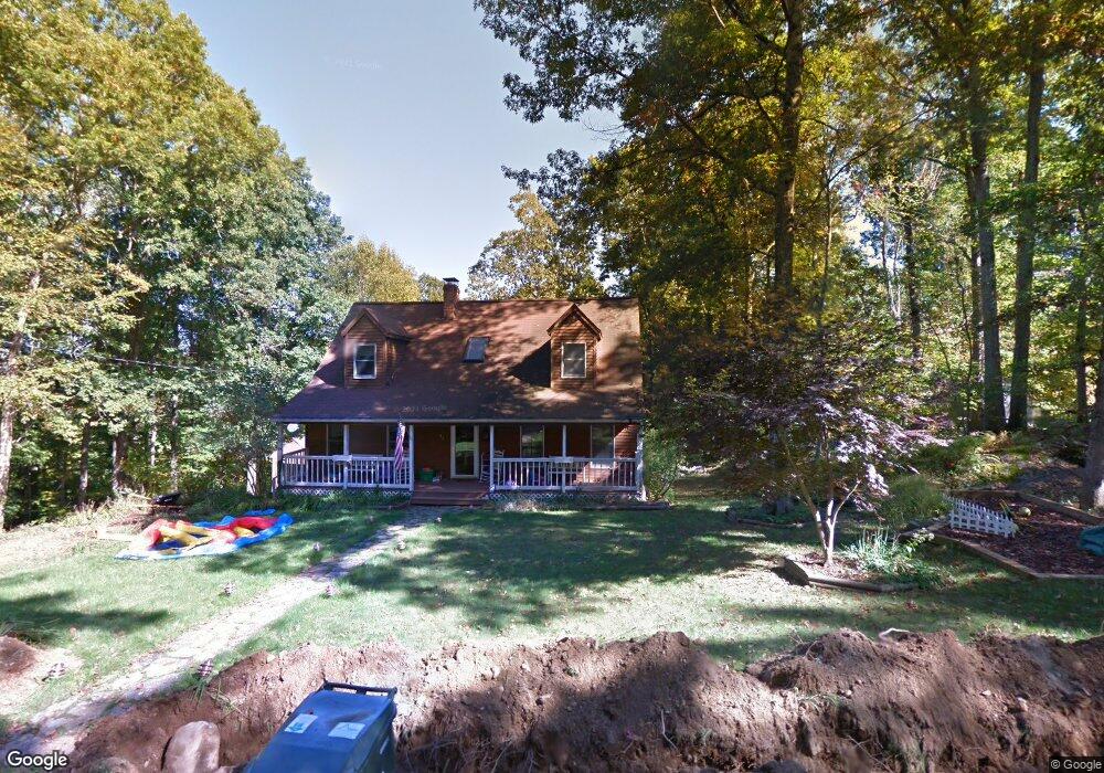
45 Hucko Trail Sandy Hook, CT 06482
Estimated Value: $556,000 - $619,000
4
Beds
2
Baths
1,680
Sq Ft
$350/Sq Ft
Est. Value
About This Home
This home is located at 45 Hucko Trail, Sandy Hook, CT 06482 and is currently estimated at $588,423, approximately $350 per square foot. 45 Hucko Trail is a home located in Fairfield County with nearby schools including Sandy Hook Elementary School, Reed Intermediate School, and Newtown Middle School.
Ownership History
Date
Name
Owned For
Owner Type
Purchase Details
Closed on
Sep 21, 2009
Sold by
Payne David T and Onyshkewych Helena M
Bought by
Fabiano Marie and Miodonka Jonathan S
Current Estimated Value
Purchase Details
Closed on
Jan 10, 2005
Sold by
Natl Res Nominee Svcs
Bought by
Onyshkewych Helena and Payne David
Purchase Details
Closed on
Jul 19, 2002
Sold by
Guidi Jack A and Guidi Sharon M
Bought by
Leary Cindy A
Create a Home Valuation Report for This Property
The Home Valuation Report is an in-depth analysis detailing your home's value as well as a comparison with similar homes in the area
Home Values in the Area
Average Home Value in this Area
Purchase History
| Date | Buyer | Sale Price | Title Company |
|---|---|---|---|
| Fabiano Marie | $355,000 | -- | |
| Fabiano Marie | $355,000 | -- | |
| Onyshkewych Helena | $383,900 | -- | |
| Natl Res Nominee Svcs | $383,900 | -- | |
| Onyshkewych Helena | $383,900 | -- | |
| Leary Cindy A | $312,900 | -- | |
| Leary Cindy A | $312,900 | -- |
Source: Public Records
Mortgage History
| Date | Status | Borrower | Loan Amount |
|---|---|---|---|
| Open | Leary Cindy A | $345,593 | |
| Closed | Leary Cindy A | $350,599 |
Source: Public Records
Tax History
| Year | Tax Paid | Tax Assessment Tax Assessment Total Assessment is a certain percentage of the fair market value that is determined by local assessors to be the total taxable value of land and additions on the property. | Land | Improvement |
|---|---|---|---|---|
| 2025 | $8,780 | $305,500 | $51,230 | $254,270 |
| 2024 | $8,239 | $305,500 | $51,230 | $254,270 |
| 2023 | $8,016 | $305,500 | $51,230 | $254,270 |
| 2022 | $7,451 | $214,920 | $48,800 | $166,120 |
| 2021 | $7,362 | $212,480 | $48,800 | $163,680 |
| 2020 | $7,386 | $212,480 | $48,800 | $163,680 |
| 2019 | $7,388 | $212,480 | $48,800 | $163,680 |
| 2018 | $7,275 | $212,480 | $48,800 | $163,680 |
| 2017 | $6,993 | $206,460 | $54,790 | $151,670 |
| 2016 | $6,937 | $206,460 | $54,790 | $151,670 |
| 2015 | $6,828 | $206,460 | $54,790 | $151,670 |
| 2014 | $6,877 | $206,460 | $54,790 | $151,670 |
Source: Public Records
Map
Nearby Homes
- 41 Chipmunk Trail
- 17 Buttonball Dr
- 108 Riverside Rd
- 22 Hemlock Trail
- 4 Sunnyview Terrace
- 89 Alpine Dr
- 16A Pole Bridge Rd
- 56 Walnut Tree Hill Rd
- 6 Crestwood Dr
- 7 Dayton St
- 7 Ford Rd
- 123 Louis Hill Rd
- 22 Misty Vale Rd
- 25 Saint George Place
- 105 Lower Fish Rock Rd
- 4 Shady Rest Blvd
- 600 Berkshire Rd
- 5 Shepaug Rd
- 12 Skidmore Ln
- 1 Owl Ridge Ln
- 9 King Phillip Trail
- 9 King Phillip Trail Unit 9a
- 60 Hucko Trail
- 28 Iris Trail
- 43 Moccasin Trail
- 5 King Phillip Trail
- 25 Moccasin Trail
- 35 Moccasin Trail
- 1 Totem Trail
- 14 Iris Trail
- 38 Moccasin Trail
- 52 Moccasin Trail
- 59 Cricket Trail
- 24 Moccasin Trail
- 51 Pootatuck Trail
- 23 Pootatuck Trail
- 4 King Phillip Trail
- 9 Pootatuck Trail
- 2 Moccasin Trail
- 19 Timbermill Rd
Your Personal Tour Guide
Ask me questions while you tour the home.