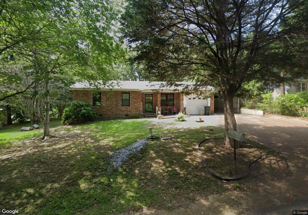
45 Parsons Rd Natchez, MS 39120
Estimated Value: $86,000 - $94,990
Studio
--
Bath
1,044
Sq Ft
$87/Sq Ft
Est. Value
About This Home
This home is located at 45 Parsons Rd, Natchez, MS 39120 and is currently estimated at $90,997, approximately $87 per square foot. 45 Parsons Rd is a home located in Adams County with nearby schools including McLaurin Elementary School, Susie B. West Primary School, and Joseph L. Frazier Primary School.
Ownership History
Date
Name
Owned For
Owner Type
Purchase Details
Closed on
Jan 15, 2016
Sold by
Lowry Patricia Ann Smith West
Bought by
Smith Patricia Ann and Smith Ora J
Current Estimated Value
Purchase Details
Closed on
Oct 14, 2015
Sold by
Ioc Natchez Inc
Bought by
Ioc Natchez Sub Llc
Purchase Details
Closed on
Jul 14, 2015
Sold by
Stenz Herman
Bought by
Stenz Aka Hermann Stenz Living Tru Adolph He
Purchase Details
Closed on
Jul 3, 2014
Sold by
Doris Ann Doris Ann and Darling Caroline B
Bought by
Jaws Investments Llc and Robert Case Holdings, Llc
Purchase Details
Closed on
Oct 31, 2013
Sold by
Winding Elbert
Bought by
Reed Ellena
Create a Home Valuation Report for This Property
The Home Valuation Report is an in-depth analysis detailing your home's value as well as a comparison with similar homes in the area
Purchase History
| Date | Buyer | Sale Price | Title Company |
|---|---|---|---|
| Smith Patricia Ann | -- | -- | |
| Ioc Natchez Sub Llc | -- | -- | |
| Stenz Aka Hermann Stenz Living Tru Adolph He | -- | -- | |
| Jaws Investments Llc | -- | -- | |
| Jaws Investments Llc | -- | -- | |
| Reed Ellena | -- | -- |
Source: Public Records
Tax History
| Year | Tax Paid | Tax Assessment Tax Assessment Total Assessment is a certain percentage of the fair market value that is determined by local assessors to be the total taxable value of land and additions on the property. | Land | Improvement |
|---|---|---|---|---|
| 2024 | $948 | $6,175 | $0 | $0 |
| 2023 | $783 | $6,175 | $910 | $5,265 |
| 2022 | $721 | $6,175 | $0 | $0 |
| 2021 | $719 | $6,175 | $0 | $0 |
| 2019 | $529 | $4,558 | $0 | $0 |
| 2018 | $529 | $4,558 | $0 | $0 |
| 2017 | $0 | $4,558 | $0 | $0 |
| 2016 | $0 | $4,889 | $0 | $0 |
| 2015 | -- | $4,889 | $0 | $0 |
| 2014 | -- | $4,889 | $0 | $0 |
Source: Public Records
Map
Nearby Homes
- 113 Mimosa Dr
- 20 Myrtle Dr
- 305 Cottage Dr
- 0 Ruby Dr Unit 4138245
- 0 Ruby Dr Unit 4138291
- 2152 Second St
- 401 Brooklyn Dr
- 1235 Magnolia Ave
- 405 Oakland Dr
- 802 Morgan Ave
- 61 South St
- 8 Newman Rd
- 114 Mount Carmel Dr
- 121 Hensley Rd
- 0 Cottonwood Dr Unit 4126881
- 0 Enterprise Dr
- 26 Cleothia Henyard Heights
- 29 Melanie Rd
- 0 Triplett Dr
- 95 W Wilderness Rd
Your Personal Tour Guide
Ask me questions while you tour the home.