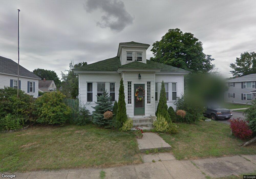
45 Randall St Manchester, NH 03103
Bakersville NeighborhoodEstimated Value: $415,000 - $440,000
3
Beds
1
Bath
1,344
Sq Ft
$319/Sq Ft
Est. Value
About This Home
This home is located at 45 Randall St, Manchester, NH 03103 and is currently estimated at $428,891, approximately $319 per square foot. 45 Randall St is a home located in Hillsborough County with nearby schools including Bakersville School, Southside Middle School, and Manchester Memorial High School.
Ownership History
Date
Name
Owned For
Owner Type
Purchase Details
Closed on
Apr 25, 2025
Sold by
Purinton Jeffrey
Bought by
Tetro Jessy-Lyn L and Santos Jennilee
Current Estimated Value
Home Financials for this Owner
Home Financials are based on the most recent Mortgage that was taken out on this home.
Original Mortgage
$135,000
Outstanding Balance
$134,156
Interest Rate
6.65%
Mortgage Type
New Conventional
Estimated Equity
$294,735
Purchase Details
Closed on
Oct 1, 1994
Bought by
Shaw Barbara E
Create a Home Valuation Report for This Property
The Home Valuation Report is an in-depth analysis detailing your home's value as well as a comparison with similar homes in the area
Home Values in the Area
Average Home Value in this Area
Purchase History
| Date | Buyer | Sale Price | Title Company |
|---|---|---|---|
| Tetro Jessy-Lyn L | -- | None Available | |
| Tetro Jessy-Lyn L | -- | None Available | |
| Shaw Barbara E | $58,000 | -- |
Source: Public Records
Mortgage History
| Date | Status | Borrower | Loan Amount |
|---|---|---|---|
| Open | Tetro Jessy-Lyn L | $135,000 | |
| Closed | Tetro Jessy-Lyn L | $135,000 |
Source: Public Records
Tax History Compared to Growth
Tax History
| Year | Tax Paid | Tax Assessment Tax Assessment Total Assessment is a certain percentage of the fair market value that is determined by local assessors to be the total taxable value of land and additions on the property. | Land | Improvement |
|---|---|---|---|---|
| 2024 | $5,872 | $299,900 | $99,700 | $200,200 |
| 2023 | $5,656 | $299,900 | $99,700 | $200,200 |
| 2022 | $5,470 | $299,900 | $99,700 | $200,200 |
| 2021 | $5,302 | $299,900 | $99,700 | $200,200 |
| 2020 | $4,530 | $183,700 | $62,200 | $121,500 |
| 2019 | $4,468 | $183,700 | $62,200 | $121,500 |
| 2018 | $4,350 | $183,700 | $62,200 | $121,500 |
| 2017 | $4,284 | $183,700 | $62,200 | $121,500 |
| 2016 | $4,251 | $183,700 | $62,200 | $121,500 |
| 2015 | $4,243 | $181,000 | $58,900 | $122,100 |
| 2014 | $4,254 | $181,000 | $58,900 | $122,100 |
| 2013 | $4,103 | $181,000 | $58,900 | $122,100 |
Source: Public Records
Map
Nearby Homes
- 160 S Elm St
- 47 Rosedale Ave
- 131 Calef Rd
- 33 W Elmhurst Ave Unit B
- 106 W Hillcrest Ave
- 118 W Hillcrest Ave
- 202 Mitchell St
- 60 W Elmwood Ave
- 152 Oakdale Ave
- 35 W Mitchell St
- 161 Flint St
- 56 Robert Ct Unit H
- 87 S Wilson St
- 507 Clay St
- 80 Billings St
- 615 Clay St
- 700 S Beech St
- 545 Calef Rd Unit 26
- 186 Bell St
- 80 Emerald St