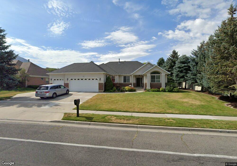
450 Ridge Dr Alpine, UT 84004
Estimated Value: $963,000 - $1,089,000
4
Beds
4
Baths
2,267
Sq Ft
$455/Sq Ft
Est. Value
About This Home
This home is located at 450 Ridge Dr, Alpine, UT 84004 and is currently estimated at $1,032,241, approximately $455 per square foot. 450 Ridge Dr is a home located in Utah County with nearby schools including Westfield School, Timberline Middle School, and Lone Peak High School.
Ownership History
Date
Name
Owned For
Owner Type
Purchase Details
Closed on
Apr 4, 2008
Sold by
Hansen Marlan and Hansen Clarene
Bought by
Hansen Clarene Townsend and Hansen Marlan
Current Estimated Value
Purchase Details
Closed on
Sep 23, 1997
Sold by
Taylor Home Inc
Bought by
Hansen Marlan and Hansen Clarene
Home Financials for this Owner
Home Financials are based on the most recent Mortgage that was taken out on this home.
Original Mortgage
$232,000
Outstanding Balance
$36,175
Interest Rate
7.54%
Estimated Equity
$996,066
Create a Home Valuation Report for This Property
The Home Valuation Report is an in-depth analysis detailing your home's value as well as a comparison with similar homes in the area
Home Values in the Area
Average Home Value in this Area
Purchase History
| Date | Buyer | Sale Price | Title Company |
|---|---|---|---|
| Hansen Clarene Townsend | -- | None Available | |
| Hansen Marlan | -- | First American Title |
Source: Public Records
Mortgage History
| Date | Status | Borrower | Loan Amount |
|---|---|---|---|
| Open | Hansen Marlan | $232,000 |
Source: Public Records
Tax History
| Year | Tax Paid | Tax Assessment Tax Assessment Total Assessment is a certain percentage of the fair market value that is determined by local assessors to be the total taxable value of land and additions on the property. | Land | Improvement |
|---|---|---|---|---|
| 2025 | $3,718 | $472,285 | -- | -- |
| 2024 | $3,718 | $433,345 | $0 | $0 |
| 2023 | $3,448 | $431,420 | $0 | $0 |
| 2022 | $3,609 | $438,570 | $0 | $0 |
| 2021 | $3,218 | $607,400 | $252,200 | $355,200 |
| 2020 | $3,126 | $577,500 | $229,300 | $348,200 |
| 2019 | $2,759 | $532,100 | $229,300 | $302,800 |
| 2018 | $2,659 | $506,600 | $203,800 | $302,800 |
| 2017 | $2,534 | $256,905 | $0 | $0 |
| 2016 | $2,711 | $256,245 | $0 | $0 |
| 2015 | $2,664 | $238,260 | $0 | $0 |
| 2014 | $2,580 | $228,250 | $0 | $0 |
Source: Public Records
Map
Nearby Homes
- 596 S Cascade Ct
- 202 E Alpine Dr
- 875 S Blue Ridge Ln
- 250 S Main St Unit 25
- 250 S Main St Unit 9
- 250 S Main St Unit 7
- 682 Healey Blvd
- 887 E Village Way
- 48 N 100 E
- 30 S Main St
- 1063 E Alpine Dr
- 259 Twin River Loop
- 5046 W Jonathon Rd Unit 10
- 499 E 300 N
- 868 S Braddock Ln
- 1103 E Lone Peak Dr
- 1201 E Preston Dr
- 243 W Conrad Ct
- 366 River Rd
- 1296 Oakwood Cir
- 470 Ridge Dr
- 445 Ponderosa Dr
- 455 Ponderosa Dr
- 410 Wood Dr
- 504 E Ridge Dr Unit 28
- 504 E Ridge Dr
- 415 Ponderosa Dr
- 504 Ridge Dr
- 475 Ridge Dr
- 485 Ponderosa Dr
- 528 Ponderosa Dr Unit 8
- 572 E Ridge Dr Unit 25
- 727 E Ridge Dr Unit 11
- 495 Ridge Dr
- 394 Wood Dr
- 448 S Ponderosa Dr
- 395 Ridge Dr
- 472 Ponderosa Dr
- 472 S Ponderosa Dr Unit 19
- 395 Wood Dr
Your Personal Tour Guide
Ask me questions while you tour the home.