Estimated Value: $332,000 - $425,000
1
Bed
1
Bath
858
Sq Ft
$438/Sq Ft
Est. Value
About This Home
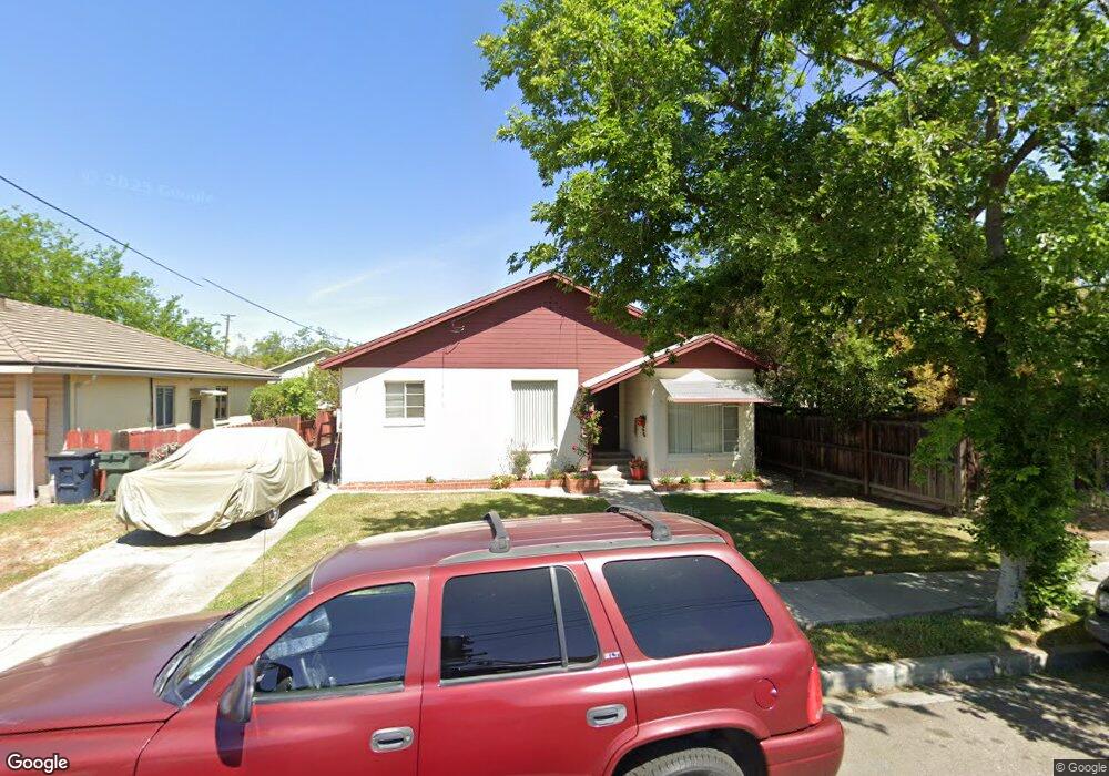
This home is located at 451 W Whittier Ave, Tracy, CA 95376 and is currently estimated at $375,740, approximately $437 per square foot. 451 W Whittier Ave is a home located in San Joaquin County with nearby schools including Central Elementary School, Merrill F. West High School, and Primary Charter School.
Ownership History
Date
Name
Owned For
Owner Type
Purchase Details
Closed on
Sep 17, 2020
Sold by
Dalpiaz Juaniga Joan
Bought by
Dalpiaz Juanita Joan and Rickets Chris
Current Estimated Value
Purchase Details
Closed on
Jun 7, 2019
Sold by
Rickets Juanita Joan
Bought by
Dalpiaz Juanita J and Rickets Chris A
Purchase Details
Closed on
Jun 7, 2005
Sold by
Rickets Juanita Joan and Marjorie Pearce L
Bought by
Rickets Juanita Joan
Purchase Details
Closed on
Apr 19, 2004
Sold by
Pearce L Marjorie
Bought by
Rickets Juanita Juan and Marjorie Pearce L
Create a Home Valuation Report for This Property
The Home Valuation Report is an in-depth analysis detailing your home's value as well as a comparison with similar homes in the area
Home Values in the Area
Average Home Value in this Area
Purchase History
| Date | Buyer | Sale Price | Title Company |
|---|---|---|---|
| Dalpiaz Juanita Joan | -- | None Available | |
| Dalpiaz Juanita J | -- | None Available | |
| Rickets Juanita Joan | -- | -- | |
| Rickets Juanita Juan | -- | -- |
Source: Public Records
Tax History Compared to Growth
Tax History
| Year | Tax Paid | Tax Assessment Tax Assessment Total Assessment is a certain percentage of the fair market value that is determined by local assessors to be the total taxable value of land and additions on the property. | Land | Improvement |
|---|---|---|---|---|
| 2025 | $573 | $48,284 | $11,762 | $36,522 |
| 2024 | $529 | $47,338 | $11,532 | $35,806 |
| 2023 | $521 | $46,410 | $11,306 | $35,104 |
| 2022 | $510 | $45,501 | $11,085 | $34,416 |
| 2021 | $505 | $44,610 | $10,868 | $33,742 |
| 2020 | $502 | $44,154 | $10,757 | $33,397 |
| 2019 | $494 | $43,290 | $10,547 | $32,743 |
| 2018 | $486 | $42,442 | $10,341 | $32,101 |
| 2017 | $462 | $41,611 | $10,139 | $31,472 |
| 2016 | $467 | $40,795 | $9,940 | $30,855 |
| 2014 | $439 | $39,395 | $9,599 | $29,796 |
Source: Public Records
Map
Nearby Homes
- 1930 Wall St
- 535 W Carlton Way
- 262 W Lowell Ave
- 1561 Bessie Ave
- 242 W Lowell Ave
- 546 W Grant Line Rd
- 228 W Lowell Ave
- 2192 Wildflower Ct
- 2214 Morningside Ct
- 110 W 23rd St
- 1792 Chester Dr
- 2840-2896 Holly Dr
- 16 Pereira Ave
- 34 Pereira Ave
- 130 E 21st St
- 1865 Newport Ct
- 80 Portola Way Unit 105
- 80 Portola Way Unit 104
- 222 Pereira Ave
- 1228 Bessie Ave
- 475 W Whittier Ave
- 437 W Whittier Ave
- 1920 Bessie Ave
- 1930 Bessie Ave
- 460 W Whittier Ave
- 427 W Whittier Ave
- 470 W Whittier Ave
- 450 W Whittier Ave
- 505 W Whittier Ave
- 1940 Bessie Ave
- 440 W Whittier Ave
- 425 W Whittier Ave
- 1826 Bessie Ave
- 1950 Bessie Ave
- 510 W Whittier Ave
- 424 W Whittier Ave
- 515 W Whittier Ave
- 1933 Bessie Ave
- 1921 Wall St
- 415 W Whittier Ave