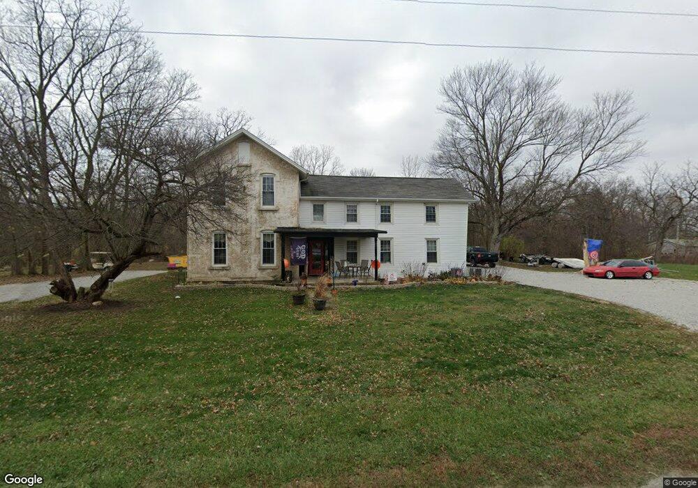
4517 State Route 99 N Monroeville, OH 44847
Estimated Value: $186,787 - $297,000
4
Beds
1
Bath
2,696
Sq Ft
$86/Sq Ft
Est. Value
About This Home
This home is located at 4517 State Route 99 N, Monroeville, OH 44847 and is currently estimated at $232,447, approximately $86 per square foot. 4517 State Route 99 N is a home located in Huron County with nearby schools including Monroeville Elementary School, Monroeville High School, and St Joseph Catholic School.
Ownership History
Date
Name
Owned For
Owner Type
Purchase Details
Closed on
Jun 15, 2021
Sold by
Roeder Jessie L
Bought by
Strecker Properties Llc
Current Estimated Value
Purchase Details
Closed on
Jun 1, 2020
Sold by
Roeder Jess K
Bought by
Roeder Jessie L
Purchase Details
Closed on
Aug 6, 2013
Bought by
Roeder W Jess K and Jessie L Roeder W
Purchase Details
Closed on
Oct 6, 2009
Bought by
Jessie L Roeder
Create a Home Valuation Report for This Property
The Home Valuation Report is an in-depth analysis detailing your home's value as well as a comparison with similar homes in the area
Home Values in the Area
Average Home Value in this Area
Purchase History
| Date | Buyer | Sale Price | Title Company |
|---|---|---|---|
| Strecker Properties Llc | $130,000 | Chicago Title | |
| Roeder Jessie L | -- | None Available | |
| Roeder W Jess K | -- | -- | |
| Roeder Jess K | -- | Attorney | |
| Jessie L Roeder | -- | -- |
Source: Public Records
Tax History Compared to Growth
Tax History
| Year | Tax Paid | Tax Assessment Tax Assessment Total Assessment is a certain percentage of the fair market value that is determined by local assessors to be the total taxable value of land and additions on the property. | Land | Improvement |
|---|---|---|---|---|
| 2024 | $2,320 | $57,670 | $10,590 | $47,080 |
| 2023 | $2,320 | $45,960 | $8,220 | $37,740 |
| 2022 | $1,988 | $45,960 | $8,220 | $37,740 |
| 2021 | $1,943 | $45,960 | $8,220 | $37,740 |
| 2020 | $1,887 | $42,700 | $6,620 | $36,080 |
| 2019 | $1,869 | $42,700 | $6,620 | $36,080 |
| 2018 | $1,794 | $42,700 | $6,620 | $36,080 |
| 2017 | $1,593 | $38,760 | $6,530 | $32,230 |
| 2016 | $1,562 | $38,760 | $6,530 | $32,230 |
| 2015 | $1,598 | $38,770 | $6,540 | $32,230 |
| 2014 | $1,512 | $40,570 | $6,550 | $34,020 |
| 2013 | $1,616 | $40,570 | $6,550 | $34,020 |
Source: Public Records
Map
Nearby Homes
- 196 Ridge St N
- 100 North St
- 101 North St
- 88 W Broad St
- 14 Ridge St N
- 17 Hollister St
- 9 Herrick Alley
- 144 Sycamore Dr
- 3170 Brown Rd
- 280 W Main St
- 42 Grassland Cir
- 102 N Pleasant St
- 6 N West St
- 4 Deer Track Trail Unit A
- 914 Wood Glen Ct
- 230 Whittlesey Ave Unit 59
- 230 Whittlesey Ave Unit 72
- 161 W Main St
- 4516 State Route 99 N
- 4541 State Route 99 N
- 4539 State Route 99 N
- 4559 State Route 99 N
- 4550 State Route 99 N
- 4391 State Route 99 N
- 4390 State Route 99 N
- 4375 State Route 99 N
- 4771 State Route 99 N
- 4259 State Route 99 N
- 4813 State Route 99 N
- 4813 Ohio 99
- 4800 State Route 99 N
- 4216 State Route 99 N
- 4934 State Route 99 N
- 3460 Mead Rd
- 3470 Mead Rd
- 3554 Us Highway 20 W
- 289 Sandusky St
- 1531 W Old Sr 20