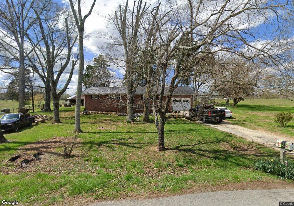
452 Graham Cir Rock Spring, GA 30739
Rock Spring NeighborhoodEstimated Value: $211,000 - $469,605
--
Bed
4
Baths
2,027
Sq Ft
$156/Sq Ft
Est. Value
About This Home
This home is located at 452 Graham Cir, Rock Spring, GA 30739 and is currently estimated at $315,202, approximately $155 per square foot. 452 Graham Cir is a home located in Walker County with nearby schools including Rock Spring Elementary School, Lafayette High School, and Alice M Daley Adventist School.
Ownership History
Date
Name
Owned For
Owner Type
Purchase Details
Closed on
Dec 4, 2019
Sold by
Larry Joyner
Bought by
Larry Joyner Robert and Robert Larry Joyner Liv Trust
Current Estimated Value
Purchase Details
Closed on
Aug 29, 2002
Sold by
Chapman Josh and Erin Chapman
Bought by
Joyner Larry
Purchase Details
Closed on
Mar 2, 2001
Sold by
Williams Williams G and Williams Elizabeth B
Bought by
Chapman Josh and Erin Chapman
Purchase Details
Closed on
Oct 7, 1997
Sold by
Williams G H
Bought by
Williams Williams G and Williams Elizabeth B
Purchase Details
Closed on
Aug 18, 1997
Sold by
Bowers Luke H and Bowers Wf
Bought by
Williams G H
Purchase Details
Closed on
Mar 19, 1970
Bought by
Bowers Luke H and Bowers Wf
Create a Home Valuation Report for This Property
The Home Valuation Report is an in-depth analysis detailing your home's value as well as a comparison with similar homes in the area
Home Values in the Area
Average Home Value in this Area
Purchase History
| Date | Buyer | Sale Price | Title Company |
|---|---|---|---|
| Larry Joyner Robert | -- | -- | |
| Joyner Larry | $25,000 | -- | |
| Chapman Josh | $13,500 | -- | |
| Williams Williams G | -- | -- | |
| Williams G H | -- | -- | |
| Bowers Luke H | -- | -- |
Source: Public Records
Tax History Compared to Growth
Tax History
| Year | Tax Paid | Tax Assessment Tax Assessment Total Assessment is a certain percentage of the fair market value that is determined by local assessors to be the total taxable value of land and additions on the property. | Land | Improvement |
|---|---|---|---|---|
| 2024 | $4,805 | $208,632 | $9,800 | $198,832 |
| 2023 | $4,681 | $198,518 | $9,800 | $188,718 |
| 2022 | $4,423 | $172,925 | $9,800 | $163,125 |
| 2021 | $4,071 | $142,515 | $9,800 | $132,715 |
| 2020 | $3,475 | $114,974 | $9,800 | $105,174 |
| 2019 | $3,536 | $114,974 | $9,800 | $105,174 |
| 2018 | $3,042 | $114,974 | $9,800 | $105,174 |
| 2017 | $3,850 | $114,974 | $9,800 | $105,174 |
| 2016 | $3,013 | $114,974 | $9,800 | $105,174 |
| 2015 | $1,728 | $58,680 | $12,320 | $46,360 |
| 2014 | $1,580 | $58,680 | $12,320 | $46,360 |
| 2013 | -- | $58,680 | $12,320 | $46,360 |
Source: Public Records
Map
Nearby Homes
- 10180 Us Highway 27
- 15 Willow Cir
- 23 Willow Cir
- 16 Willow Cir
- 11 Willow Cir
- The Pearson Plan at Laurel Ridge
- The Benson II Plan at Laurel Ridge
- The Langford Plan at Laurel Ridge
- The Lawson Plan at Laurel Ridge
- The Piedmont Plan at Laurel Ridge
- The Coleman Plan at Laurel Ridge
- The McGinnis Plan at Laurel Ridge
- The Caldwell Plan at Laurel Ridge
- 1003 Highway N Old 27
- 1370 Old Highway 27
- 5602 Georgia 95
- 00 Georgia 95
- 701 Bicentennial Trail