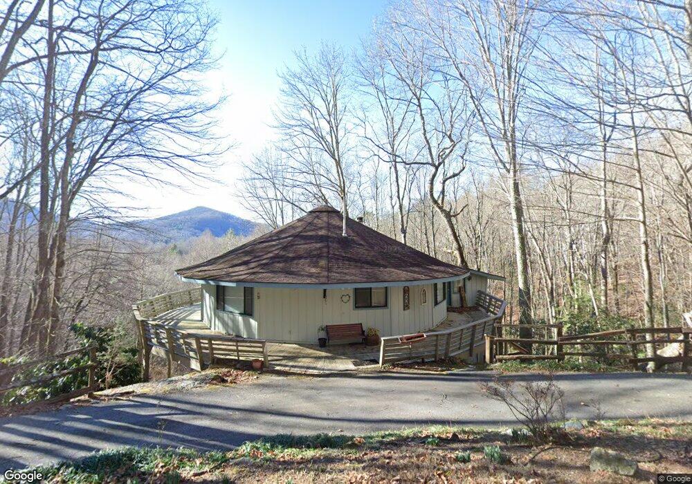
452 Sky High Dr Dillard, GA 30537
Estimated Value: $359,000 - $438,000
3
Beds
3
Baths
2,280
Sq Ft
$169/Sq Ft
Est. Value
About This Home
This home is located at 452 Sky High Dr, Dillard, GA 30537 and is currently estimated at $384,391, approximately $168 per square foot. 452 Sky High Dr is a home located in Rabun County with nearby schools including Rabun County Primary School and Rabun County High School.
Ownership History
Date
Name
Owned For
Owner Type
Purchase Details
Closed on
Mar 29, 2016
Sold by
Edmiston Margaret
Bought by
Sval Llc
Current Estimated Value
Purchase Details
Closed on
Feb 21, 2014
Sold by
Edmiston Margaret Flipse
Bought by
Edmiston Margaret Flipse
Purchase Details
Closed on
May 1, 2001
Bought by
Edmiston Charles W
Purchase Details
Closed on
Aug 1, 1981
Purchase Details
Closed on
Jul 1, 1980
Purchase Details
Closed on
Oct 1, 1979
Create a Home Valuation Report for This Property
The Home Valuation Report is an in-depth analysis detailing your home's value as well as a comparison with similar homes in the area
Home Values in the Area
Average Home Value in this Area
Purchase History
We collect this data history from publicly available records. To have your information removed, we recommend requesting removal directly through your county’s website.
| Date | Buyer | Sale Price | Title Company |
|---|---|---|---|
| Sval Llc | $110,000 | -- | |
| Sval Llc | $110,000 | -- | |
| Edmiston Margaret Flipse | -- | -- | |
| Edmiston Margaret Flipse | -- | -- | |
| Edmiston Charles W | -- | -- | |
| Edmiston Charles W | -- | -- | |
| -- | $20,400 | -- | |
| -- | $40,800 | -- | |
| -- | $20,400 | -- | |
| -- | $40,800 | -- | |
| -- | $20,000 | -- | |
| -- | $39,000 | -- | |
| -- | $39,000 | -- |
Source: Public Records
Tax History
| Year | Tax Paid | Tax Assessment Tax Assessment Total Assessment is a certain percentage of the fair market value that is determined by local assessors to be the total taxable value of land and additions on the property. | Land | Improvement |
|---|---|---|---|---|
| 2025 | $2,876 | $104,126 | $27,000 | $77,126 |
| 2024 | $2,741 | $99,231 | $27,000 | $72,231 |
| 2023 | $2,432 | $77,715 | $21,600 | $56,115 |
| 2022 | $1,289 | $70,412 | $18,900 | $51,512 |
| 2021 | $1,053 | $56,143 | $10,800 | $45,343 |
| 2020 | $987 | $50,898 | $10,800 | $40,098 |
| 2019 | $994 | $50,898 | $10,800 | $40,098 |
| 2018 | $998 | $50,898 | $10,800 | $40,098 |
| 2017 | $824 | $43,841 | $10,800 | $33,041 |
| 2016 | $960 | $50,902 | $9,600 | $41,302 |
| 2015 | $916 | $47,557 | $9,600 | $37,957 |
| 2014 | $921 | $47,557 | $9,600 | $37,957 |
Source: Public Records
Map
Nearby Homes
- 480 Sky High Dr
- 1085 Sky High Dr
- 594 Sky High Dr
- 42 Lost Valley Dr
- 0 LOT 41 Pipetrack Gap Rd
- 0 LOT 40 Pipetrack Gap Rd
- 0 Pipetrack Gap Rd Unit 1003152
- LOT 35 Thomas Knob Estates Rd
- 767 Driver Ln
- 70 Fairway Ln
- 119 Buttermilk Cir
- 0 LOT 5 Rebel Cir
- 0 LOT 41 Rebel Cir
- 63 Mashie Ln
- 522 Rebel Cir
- 0 Saddleback Cir Unit 10538862
- 4 Saddleback Cir
- 156 Tahoe Ln
- 137 Pleasant Mountain Dr
- 374 W Sugarbush Dr
- 452 Sky High Dr Unit 107
- 480 Sky High Dr Unit 110
- Lot#89 Northwoods 3 (Sky High Drive)
- Lot#89 Northwoods 3 (Sky High Dr)
- Lot#89 Northwoods 3 (Sky High Dr) Unit Lot89
- 941 Sky High Dr
- 965 Sky High Dr Unit 86
- 965 Sky High Dr
- 1007 Sky High Dr
- 350 Sky High Dr
- 350 Sky High Dr Unit 104
- 717 Bald Mountain Rd
- 689 Bald Mountain Rd Unit 102
- 689 Bald Mountain Rd
- 717 Bald Mountain Rd
- 528 Sky High Dr
- 00 Sky High Dr
- 921 Sky High Dr
- Lot 28 Sky High Dr
- 322 Sky High Dr
Your Personal Tour Guide
Ask me questions while you tour the home.