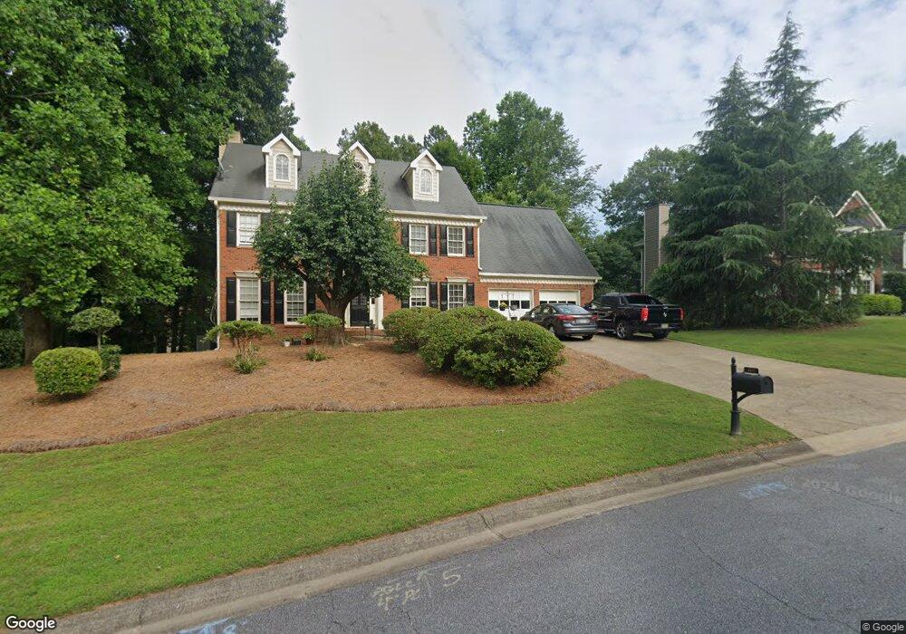
4522 Forest Peak Cir Marietta, GA 30066
Sandy Plains NeighborhoodEstimated Value: $612,000 - $755,000
4
Beds
3
Baths
2,945
Sq Ft
$227/Sq Ft
Est. Value
About This Home
This home is located at 4522 Forest Peak Cir, Marietta, GA 30066 and is currently estimated at $668,384, approximately $226 per square foot. 4522 Forest Peak Cir is a home located in Cobb County with nearby schools including Davis Elementary School, Mabry Middle School, and Lassiter High School.
Ownership History
Date
Name
Owned For
Owner Type
Purchase Details
Closed on
Sep 13, 2024
Sold by
Queen Joe Randall and Queen Bonnie Lea
Bought by
Queen Family Trust and Queen
Current Estimated Value
Purchase Details
Closed on
Jun 21, 2024
Sold by
Queen Joe Randall and Queen Kim Diane
Bought by
Queen Joe Randall and Queen Bonnie Lee
Create a Home Valuation Report for This Property
The Home Valuation Report is an in-depth analysis detailing your home's value as well as a comparison with similar homes in the area
Home Values in the Area
Average Home Value in this Area
Purchase History
| Date | Buyer | Sale Price | Title Company |
|---|---|---|---|
| Queen Family Trust | -- | None Listed On Document | |
| Queen Joe Randall | -- | None Listed On Document |
Source: Public Records
Tax History Compared to Growth
Tax History
| Year | Tax Paid | Tax Assessment Tax Assessment Total Assessment is a certain percentage of the fair market value that is determined by local assessors to be the total taxable value of land and additions on the property. | Land | Improvement |
|---|---|---|---|---|
| 2025 | $1,290 | $224,308 | $60,000 | $164,308 |
| 2024 | $1,294 | $224,308 | $60,000 | $164,308 |
| 2023 | $1,088 | $224,308 | $60,000 | $164,308 |
| 2022 | $1,194 | $190,984 | $40,000 | $150,984 |
| 2021 | $1,112 | $163,412 | $40,000 | $123,412 |
| 2020 | $1,112 | $163,412 | $40,000 | $123,412 |
| 2019 | $1,112 | $163,412 | $40,000 | $123,412 |
| 2018 | $1,049 | $142,388 | $36,800 | $105,588 |
| 2017 | $938 | $142,388 | $36,800 | $105,588 |
| 2016 | $889 | $124,860 | $31,600 | $93,260 |
| 2015 | $954 | $124,860 | $31,600 | $93,260 |
| 2014 | $3,146 | $124,860 | $0 | $0 |
Source: Public Records
Map
Nearby Homes
- 4243 N Mountain Rd NE
- 4219 N Mountain Rd NE
- 4302 Highborne Dr NE Unit 3
- 4734 Outlook Way NE
- 4563 Ashmore Cir NE
- 4380 Wood Creek Dr
- 3333 Devaughn Dr NE
- 4397 Windsor Oaks Cir
- 4589 Wigley Estates Rd
- 3465 Township Ridge Point
- 3043 Sawyer Trace NE
- 3350 Brookhill Cir
- 130 Cherecobb Dr
- 2855 Lamer Trace
- 2842 Forest Chase Dr NE
- 3870 Sweat Creek Run
- 920 Lucky Ln
- 3480 Pebble Hill Dr
- 422 Stovall Place
- 415 Bellehaven Ln
- 4520 Forest Peak Cir Unit 2
- 0 Forest Peak Cir Unit 7485154
- 0 Forest Peak Cir Unit 7210630
- 0 Forest Peak Cir Unit 8636541
- 0 Forest Peak Cir Unit 8610290
- 0 Forest Peak Cir Unit 8235231
- 0 Forest Peak Cir Unit 8855930
- 0 Forest Peak Cir Unit 8735028
- 0 Forest Peak Cir Unit 8683485
- 0 Forest Peak Cir Unit 7526011
- 0 Forest Peak Cir Unit 7111150
- 0 Forest Peak Cir Unit 3128727
- 0 Forest Peak Cir Unit 3242408
- 0 Forest Peak Cir Unit 8956105
- 0 Forest Peak Cir Unit 8957438
- 4524 Forest Peak Cir
- 4517 Forest Peak Cir Unit 2
- 3632 Lone Indian Trail
- 3630 Lone Indian Trail
- 4518 Forest Peak Cir