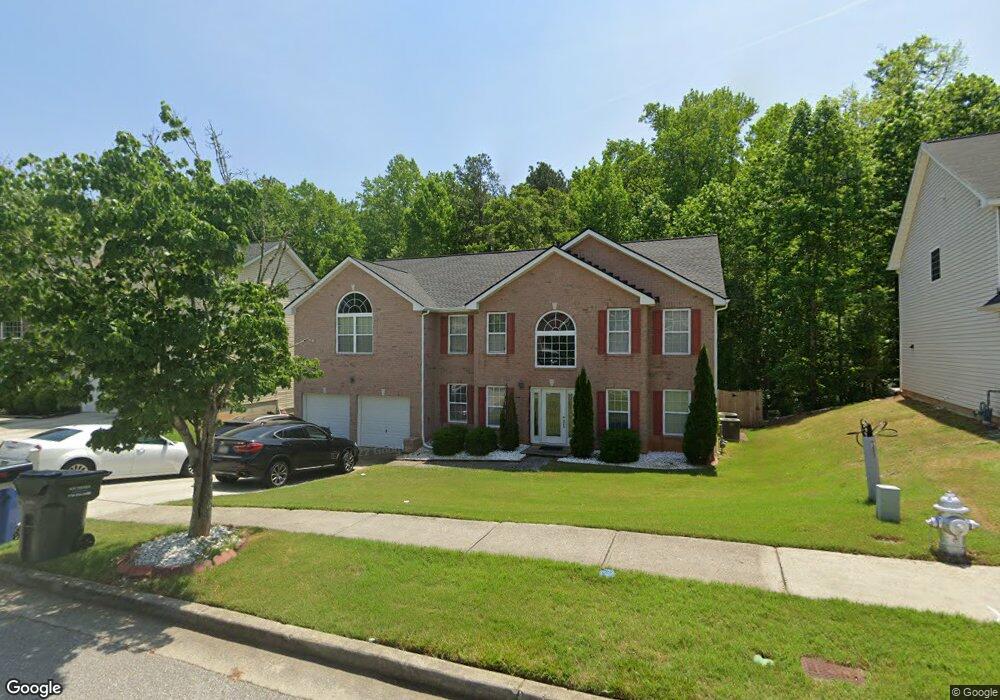
4524 Michael Jay St Snellville, GA 30039
Estimated Value: $407,613 - $441,000
5
Beds
3
Baths
3,392
Sq Ft
$125/Sq Ft
Est. Value
About This Home
This home is located at 4524 Michael Jay St, Snellville, GA 30039 and is currently estimated at $422,403, approximately $124 per square foot. 4524 Michael Jay St is a home located in Gwinnett County with nearby schools including Rosebud Elementary School, Grace Snell Middle School, and South Gwinnett High School.
Ownership History
Date
Name
Owned For
Owner Type
Purchase Details
Closed on
Nov 3, 2006
Sold by
Robinson Cory S
Bought by
Robinson Cory S and Keys Debra
Current Estimated Value
Home Financials for this Owner
Home Financials are based on the most recent Mortgage that was taken out on this home.
Original Mortgage
$230,920
Outstanding Balance
$136,319
Interest Rate
6.36%
Mortgage Type
FHA
Estimated Equity
$286,084
Create a Home Valuation Report for This Property
The Home Valuation Report is an in-depth analysis detailing your home's value as well as a comparison with similar homes in the area
Home Values in the Area
Average Home Value in this Area
Purchase History
| Date | Buyer | Sale Price | Title Company |
|---|---|---|---|
| Robinson Cory S | $232,745 | -- | |
| Robinson Cory S | $232,800 | -- |
Source: Public Records
Mortgage History
| Date | Status | Borrower | Loan Amount |
|---|---|---|---|
| Open | Robinson Cory S | $230,920 |
Source: Public Records
Tax History Compared to Growth
Tax History
| Year | Tax Paid | Tax Assessment Tax Assessment Total Assessment is a certain percentage of the fair market value that is determined by local assessors to be the total taxable value of land and additions on the property. | Land | Improvement |
|---|---|---|---|---|
| 2025 | $5,347 | $191,920 | $30,000 | $161,920 |
| 2024 | $4,841 | $160,000 | $30,000 | $130,000 |
| 2023 | $4,841 | $160,720 | $29,680 | $131,040 |
| 2022 | $4,291 | $135,040 | $22,000 | $113,040 |
| 2021 | $3,764 | $107,040 | $14,000 | $93,040 |
| 2020 | $3,545 | $95,760 | $14,000 | $81,760 |
| 2019 | $3,424 | $95,760 | $14,000 | $81,760 |
| 2018 | $3,196 | $88,080 | $12,000 | $76,080 |
| 2016 | $2,563 | $69,440 | $10,000 | $59,440 |
| 2015 | $2,348 | $62,640 | $8,800 | $53,840 |
| 2014 | -- | $62,640 | $8,800 | $53,840 |
Source: Public Records
Map
Nearby Homes
- 4381 Ash Tree St
- 4041 Ash Tree St
- 4850 Wynship Ln
- 4348 Bradley Dr
- 4366 Bradley Dr SW
- 4244 Bradley Dr SW
- 0 Bradley Dr SW
- 3770 Belle Glade Trail
- 4380 Cary Dr
- 0 Bryant Rd Unit 7646847
- 4440 Cary Dr
- 4440 Cary Dr SW
- 4738 Chafin Point Ct
- 4656 Bryant Rd
- 4232 Marjorie Rd
- 4840 Heather Mill Trace
- 4469 Persian Ct
- 3890 Irwin Bridge Rd NW
- 3880 Irwin Bridge Rd NW
- 4514 Michael Jay St
- 4534 Michael Jay St
- 4504 Michael Jay St
- 4544 Michael Jay St
- 4525 Michael Jay St
- 4515 Michael Jay St
- 4535 Michael Jay St Unit 26
- 4535 Michael Jay St
- 4494 Michael Jay St
- 4505 Michael Jay St
- 4554 Michael Jay St
- 4545 Michael Jay St
- 4485 Michael Jay St
- 4484 Michael Jay St
- 4555 Michael Jay St
- 4564 Michael Jay St
- 4917 Bottle Brush Ct
- 4475 Michael Jay St
- 4907 Bottle Brush Ct
- 4927 Bottle Brush Ct