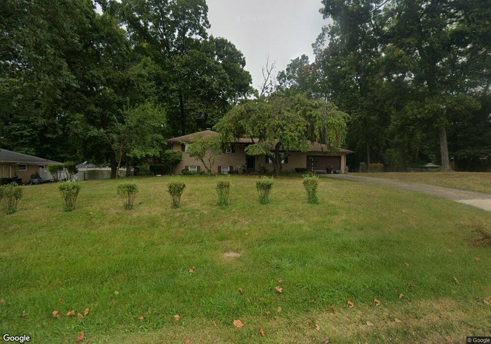
4525 Derr Rd Springfield, OH 45503
Estimated Value: $211,843 - $343,000
3
Beds
1
Bath
1,150
Sq Ft
$266/Sq Ft
Est. Value
About This Home
This home is located at 4525 Derr Rd, Springfield, OH 45503 and is currently estimated at $305,461, approximately $265 per square foot. 4525 Derr Rd is a home located in Clark County with nearby schools including Northridge Elementary School, Kenton Ridge Middle & High School, and Emmanuel Christian Academy.
Ownership History
Date
Name
Owned For
Owner Type
Purchase Details
Closed on
Feb 11, 2016
Sold by
Corner Donna J
Bought by
Board Of Clark County Commissioners
Current Estimated Value
Purchase Details
Closed on
Sep 1, 1980
Sold by
Maurer Wayne O and Maurer Kathy A
Bought by
Comer Donna J
Create a Home Valuation Report for This Property
The Home Valuation Report is an in-depth analysis detailing your home's value as well as a comparison with similar homes in the area
Home Values in the Area
Average Home Value in this Area
Purchase History
| Date | Buyer | Sale Price | Title Company |
|---|---|---|---|
| Board Of Clark County Commissioners | $2,294 | None Available | |
| Comer Donna J | $58,000 | -- |
Source: Public Records
Tax History
| Year | Tax Paid | Tax Assessment Tax Assessment Total Assessment is a certain percentage of the fair market value that is determined by local assessors to be the total taxable value of land and additions on the property. | Land | Improvement |
|---|---|---|---|---|
| 2025 | $14,222 | $61,960 | $14,380 | $47,580 |
| 2024 | $21,261 | $53,270 | $11,160 | $42,110 |
| 2023 | $11,132 | $53,270 | $11,160 | $42,110 |
| 2022 | $15,658 | $53,270 | $11,160 | $42,110 |
| 2021 | $1,748 | $43,660 | $9,150 | $34,510 |
| 2020 | $1,750 | $43,660 | $9,150 | $34,510 |
| 2019 | $1,783 | $43,660 | $9,150 | $34,510 |
| 2018 | $1,576 | $38,370 | $8,470 | $29,900 |
| 2017 | $1,351 | $38,371 | $8,467 | $29,904 |
| 2016 | $1,361 | $38,808 | $8,904 | $29,904 |
| 2015 | $1,284 | $36,092 | $8,904 | $27,188 |
| 2014 | $1,285 | $36,092 | $8,904 | $27,188 |
| 2013 | $1,255 | $36,092 | $8,904 | $27,188 |
Source: Public Records
Map
Nearby Homes
- 862 Brendle Trace Unit 20
- 4741 Cullen Ave
- 4343 Burchill St
- 4802 Willowbrook Dr
- 593 Hiser Ave
- 1341 Student Ave
- 4256 Midfield St Unit 9
- 4446 Ridgewood Rd E Unit 3
- 5033 Ridgewood Rd E
- 4652 Reno Ln Unit 15
- 1709 Thomas Dr
- 1521 Erika Dr
- 1162 Kingsgate Rd
- 1201 Kingsgate Rd
- 0 Moorefield Rd
- 5564 Ridgewood Rd W
- 5564 Ridgewood Rd E Unit 7
- 1500 Kingsgate Rd
- 1502 Kingsgate Rd
- 1500 Kingsgate Rd Unit 19430
- 4545 Derr Rd
- 4509 Derr Rd
- 4534 Dunnwood Ln
- 4522 Dunnwood Ln
- 4514 Dunnwood Ln
- 932 Sawmill Ct
- 4501 Derr Rd
- 4504 Dunnwood Ln
- 939 Hunt Pkwy
- 925 Sawmill Ct
- 928 Sawmill Ct
- 954 Forest Edge Ave
- 884 Brendle Trace Unit 26
- 1018 Cheyenne Ave
- 4505 Dunnwood Ln
- 882 Brendle Trace
- 921 Sawmill Ct
- 1024 Cheyenne Ave
- 888 Brendle Trace
- 1035 Westmont Cir
Your Personal Tour Guide
Ask me questions while you tour the home.