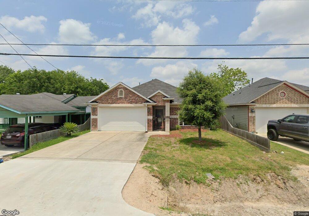
4525 White Rock St Houston, TX 77051
Sunnyside NeighborhoodEstimated Value: $212,000 - $252,000
3
Beds
2
Baths
1,356
Sq Ft
$171/Sq Ft
Est. Value
About This Home
This home is located at 4525 White Rock St, Houston, TX 77051 and is currently estimated at $232,313, approximately $171 per square foot. 4525 White Rock St is a home located in Harris County with nearby schools including Young Elementary School, Attucks Middle School, and Worthing High School.
Ownership History
Date
Name
Owned For
Owner Type
Purchase Details
Closed on
Jun 29, 2016
Sold by
Pratchett Ashten
Bought by
Johnson Leon E
Current Estimated Value
Home Financials for this Owner
Home Financials are based on the most recent Mortgage that was taken out on this home.
Original Mortgage
$135,859
Outstanding Balance
$108,456
Interest Rate
3.58%
Mortgage Type
VA
Estimated Equity
$123,857
Purchase Details
Closed on
Sep 3, 2015
Sold by
Su Lang
Bought by
Pratrchett Ashten
Purchase Details
Closed on
May 6, 2014
Sold by
Franklin Norman
Bought by
Su Lang
Create a Home Valuation Report for This Property
The Home Valuation Report is an in-depth analysis detailing your home's value as well as a comparison with similar homes in the area
Home Values in the Area
Average Home Value in this Area
Purchase History
| Date | Buyer | Sale Price | Title Company |
|---|---|---|---|
| Johnson Leon E | -- | Stewart Title Co | |
| Pratrchett Ashten | -- | Startex Title Co | |
| Su Lang | $2,000 | None Available |
Source: Public Records
Mortgage History
| Date | Status | Borrower | Loan Amount |
|---|---|---|---|
| Open | Johnson Leon E | $135,859 |
Source: Public Records
Tax History Compared to Growth
Tax History
| Year | Tax Paid | Tax Assessment Tax Assessment Total Assessment is a certain percentage of the fair market value that is determined by local assessors to be the total taxable value of land and additions on the property. | Land | Improvement |
|---|---|---|---|---|
| 2025 | $3,119 | $253,364 | $78,750 | $174,614 |
| 2024 | $3,119 | $237,767 | $73,500 | $164,267 |
| 2023 | $3,119 | $283,131 | $68,250 | $214,881 |
| 2022 | $4,591 | $237,171 | $52,500 | $184,671 |
| 2021 | $4,418 | $198,121 | $36,750 | $161,371 |
| 2020 | $4,173 | $172,325 | $30,188 | $142,137 |
| 2019 | $4,199 | $165,930 | $22,313 | $143,617 |
| 2018 | $2,804 | $152,667 | $15,750 | $136,917 |
| 2017 | $3,968 | $156,915 | $11,813 | $145,102 |
| 2016 | $299 | $11,813 | $11,813 | $0 |
| 2015 | $199 | $11,813 | $11,813 | $0 |
| 2014 | $199 | $11,813 | $11,813 | $0 |
Source: Public Records
Map
Nearby Homes
- 4523 Sunflower St
- 4548 Briscoe St
- 4608 White Rock St
- 4545 Bricker St
- 4524 Rosemont St Unit A/B
- 8505 Rubin St
- 4638 Sunflower St Unit 9
- 4314 Sunflower St
- 4614 Redbud St
- 7905 Rock Rose St
- 4312 Sunflower St
- 4429 Sterling St Unit A and B
- 8521 Dosia St
- 1202 Vera Lou St
- 4418 Rosemont St
- 4555 Newberry St
- 8201 Calhoun Rd Unit A/B
- 4427 Elmwood St
- 4425 Elmwood St
- 4741 Bricker St
- 4521 White Rock St
- 4531 White Rock St
- 4519 White Rock St
- 4528 Briscoe St
- 4532 Briscoe St
- 4520 Briscoe St
- 4517 White Rock St
- 4542 Briscoe St
- 4528 White Rock St
- 4526 White Rock St
- 4518 Briscoe St
- 4530 White Rock St
- 4522 White Rock St
- 4515 White Rock St
- 4518 White Rock St
- 4516 Briscoe St
- 4534 White Rock St
- 4513 White Rock St
- 4513 White Rock St
- 4513 White Rock St Unit 1