
453 Route 33 E East Windsor, NJ 08520
Estimated payment $3,226/month
Highlights
- In Ground Pool
- Backs to Trees or Woods
- No HOA
- Cape Cod Architecture
- 1 Fireplace
- 2 Car Attached Garage
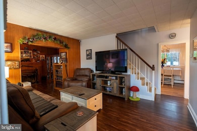
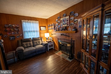
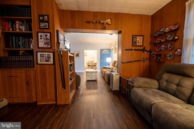
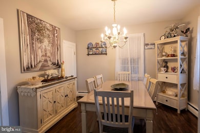
About This Home
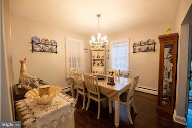
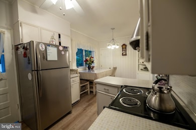
This well maintained, completely improved cape is being offered at a price for anyone to make their own. 3 bedroom, 2 full bathroom with full basement, in ground pool that has been nicely hardscaped with a large patio for outdoor entertaining, and the backyard is fenced with a 6-foot vinyl privacy fence for to provide your own personal oasis. The first floor features living room, formal dining room, a den with fireplace, full bathroom and eat in kitchen with main level laundry. Upstairs, there are three nicely sized bedrooms with full bathroom. The basement has the potential to be easily refinished. The home features a two-car attached garage with 200amp service to the property. The heating system has been upgraded to a Roth tank, assuring years of worry-free reliability. Perfect for any trade enthusiast or home business owner who likes to work from home, as the property is commercially zoned, with easy access to all major arteries. The owner is pricing the home competitively to sell fast and easy with no contingencies. No known defects, but the home is priced and offered in as is condition for its next owner to improve.
Listing Agent
(609) 819-5171 ravallone@gmail.com ERA Central Levinson License #1645777 Listed on: 10/19/2025
Home Details
Home Type
- Single Family
Est. Annual Taxes
- $8,701
Year Built
- Built in 1946
Lot Details
- 0.27 Acre Lot
- Lot Dimensions are 100.00 x 117.00
- South Facing Home
- Year Round Access
- Privacy Fence
- Vinyl Fence
- Panel Fence
- Extensive Hardscape
- Level Lot
- Backs to Trees or Woods
- Back and Front Yard
- Property is in good condition
- Property is zoned TC
Parking
- 2 Car Attached Garage
- Parking Storage or Cabinetry
- Front Facing Garage
- Garage Door Opener
Home Design
- Cape Cod Architecture
- Transitional Architecture
- Block Foundation
- Architectural Shingle Roof
- Asphalt Roof
- Vinyl Siding
Interior Spaces
- 1,575 Sq Ft Home
- Property has 3 Levels
- 1 Fireplace
- Laundry on main level
Kitchen
- Stove
- Dishwasher
Bedrooms and Bathrooms
- 3 Main Level Bedrooms
- 2 Full Bathrooms
Improved Basement
- Basement Fills Entire Space Under The House
- Interior and Exterior Basement Entry
- Sump Pump
- Rough-In Basement Bathroom
Outdoor Features
- In Ground Pool
- Patio
- Outbuilding
Utilities
- Multiple cooling system units
- Window Unit Cooling System
- Heating System Uses Oil
- Hot Water Baseboard Heater
- 100 Amp Service
- Oil Water Heater
- Private Sewer
- Phone Available
- Cable TV Available
Community Details
- No Home Owners Association
Listing and Financial Details
- Tax Lot 00003
- Assessor Parcel Number 01-00019-00003
Map
Home Values in the Area
Average Home Value in this Area
Tax History
| Year | Tax Paid | Tax Assessment Tax Assessment Total Assessment is a certain percentage of the fair market value that is determined by local assessors to be the total taxable value of land and additions on the property. | Land | Improvement |
|---|---|---|---|---|
| 2025 | $8,701 | $233,900 | $90,500 | $143,400 |
| 2024 | $8,238 | $233,900 | $90,500 | $143,400 |
| 2023 | $8,238 | $233,900 | $90,500 | $143,400 |
| 2022 | $8,025 | $233,900 | $90,500 | $143,400 |
| 2021 | $7,967 | $233,900 | $90,500 | $143,400 |
| 2020 | $7,976 | $233,900 | $90,500 | $143,400 |
| 2019 | $7,903 | $233,900 | $90,500 | $143,400 |
| 2018 | $7,801 | $233,900 | $90,500 | $143,400 |
| 2017 | $7,794 | $233,900 | $90,500 | $143,400 |
| 2016 | $7,684 | $233,900 | $90,500 | $143,400 |
| 2015 | $7,534 | $233,900 | $90,500 | $143,400 |
| 2014 | $7,445 | $233,900 | $90,500 | $143,400 |
Property History
| Date | Event | Price | List to Sale | Price per Sq Ft |
|---|---|---|---|---|
| 10/30/2025 10/30/25 | Pending | -- | -- | -- |
| 10/19/2025 10/19/25 | For Sale | $475,000 | -- | $302 / Sq Ft |
Purchase History
| Date | Type | Sale Price | Title Company |
|---|---|---|---|
| Deed | $128,900 | -- |
Mortgage History
| Date | Status | Loan Amount | Loan Type |
|---|---|---|---|
| Closed | $129,000 | FHA |
Source: Bright MLS
MLS Number: NJME2067566
APN: 01-00019-0000-00003
Disclaimer: Certain information contained herein is derived from information provided by parties other than Homes.com. All information provided is deemed reliable, but is not guaranteed to be accurate and should be independently verified.
![]() The data relating to real estate for sale on this website appears in part through the BRIGHT Internet Data Exchange program, a voluntary cooperative exchange of property listing data between licensed real estate brokerage firms, and is provided by BRIGHT through a licensing agreement.
The data relating to real estate for sale on this website appears in part through the BRIGHT Internet Data Exchange program, a voluntary cooperative exchange of property listing data between licensed real estate brokerage firms, and is provided by BRIGHT through a licensing agreement.
Listing information is from various brokers who participate in the Bright MLS IDX program and not all listings may be visible on the site.
The property information being provided on or through the website is for the personal, non-commercial use of consumers and such information may not be used for any purpose other than to identify prospective properties consumers may be interested in purchasing.
Some properties which appear for sale on the website may no longer be available because they are for instance, under contract, sold or are no longer being offered for sale.
Property information displayed is deemed reliable but is not guaranteed.
Copyright 2025 Bright MLS, Inc.
- 336 Monmouth St
- 43 Norton Ave
- 13 Avon Dr Unit P
- 219 Maxwell Ave
- 344 Monmouth St
- 234 Probasco Rd
- 23 Barton Dr
- 4 Brakeman Ct
- C9 Avon Dr E
- 203 Canterbury Ct
- D16 Avon Dr
- 406 Bolton Rd
- 197 Canterbury Ct
- 1 Huber Ct
- 164 Mill Run E Unit 141
- 1N Lake Dr
- 127 Probasco Rd
- 126 Mill Run E
- 126 Mill Run E Unit 84
- 124 Mill Run E Unit 85
