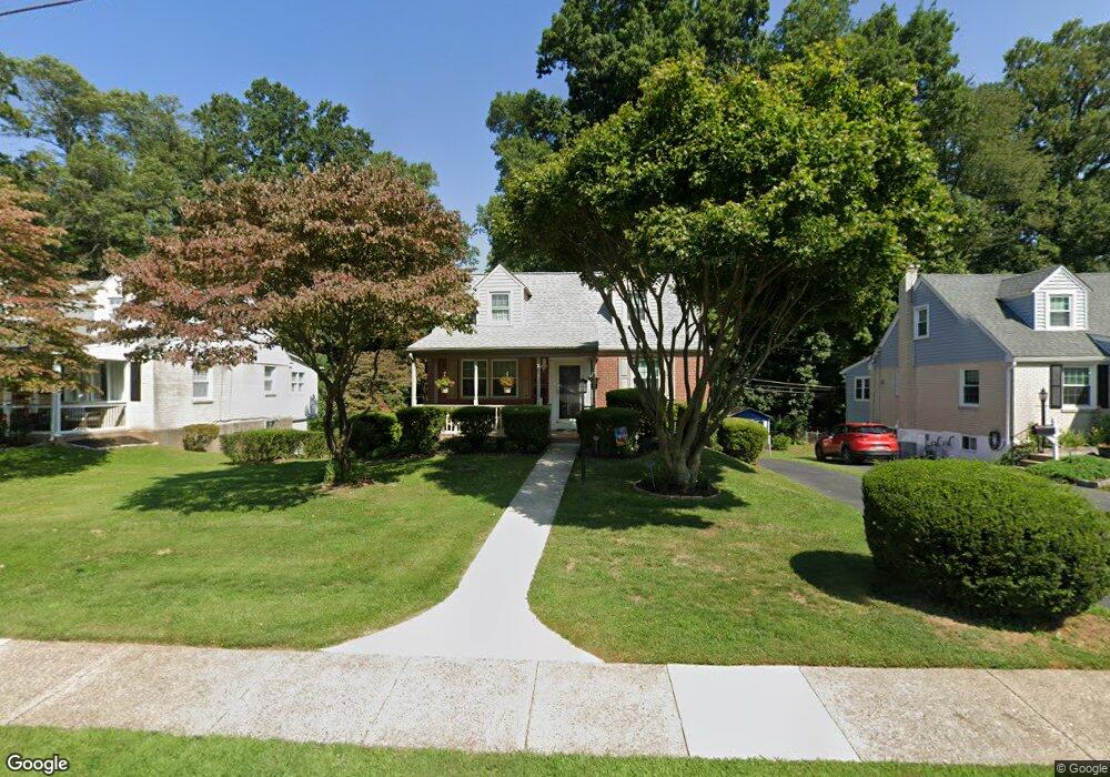
453 Sherman Rd Springfield, PA 19064
Estimated Value: $473,839 - $488,000
3
Beds
2
Baths
1,629
Sq Ft
$295/Sq Ft
Est. Value
About This Home
This home is located at 453 Sherman Rd, Springfield, PA 19064 and is currently estimated at $481,210, approximately $295 per square foot. 453 Sherman Rd is a home located in Delaware County with nearby schools including Springfield High School, Holy Cross School, and Sonshine Christian Academy.
Ownership History
Date
Name
Owned For
Owner Type
Purchase Details
Closed on
Aug 30, 1993
Sold by
Soulas Timothy P and Soulas Katherine A
Bought by
Riviello Karen E
Current Estimated Value
Create a Home Valuation Report for This Property
The Home Valuation Report is an in-depth analysis detailing your home's value as well as a comparison with similar homes in the area
Home Values in the Area
Average Home Value in this Area
Purchase History
We collect this data history from publicly available records. To have your information removed, we recommend requesting removal directly through your county’s website.
| Date | Buyer | Sale Price | Title Company |
|---|---|---|---|
| Riviello Karen E | $155,500 | -- |
Source: Public Records
Tax History
| Year | Tax Paid | Tax Assessment Tax Assessment Total Assessment is a certain percentage of the fair market value that is determined by local assessors to be the total taxable value of land and additions on the property. | Land | Improvement |
|---|---|---|---|---|
| 2026 | $8,009 | $267,210 | $95,920 | $171,290 |
| 2025 | $7,510 | $267,210 | $95,920 | $171,290 |
| 2024 | $7,510 | $267,210 | $95,920 | $171,290 |
| 2023 | $7,232 | $267,210 | $95,920 | $171,290 |
| 2022 | $7,075 | $267,210 | $95,920 | $171,290 |
| 2021 | $10,957 | $267,210 | $95,920 | $171,290 |
| 2020 | $6,265 | $138,250 | $46,120 | $92,130 |
| 2019 | $6,118 | $138,250 | $46,120 | $92,130 |
| 2018 | $6,030 | $138,250 | $0 | $0 |
| 2017 | $5,890 | $138,250 | $0 | $0 |
| 2016 | $759 | $124,950 | $0 | $0 |
| 2015 | $700 | $124,950 | $0 | $0 |
| 2014 | $700 | $124,950 | $0 | $0 |
Source: Public Records
Map
Nearby Homes
- 453 Claremont Rd
- 418 Colonial Park Dr
- 548 Claremont Rd
- 637 N Bishop Ave
- 324 Valley View Rd
- 599 N Bishop Ave
- 4913 Woodland Ave
- 503 Bloomfield Ave
- 516 Anderson Ave
- 401 N Rolling Rd
- 508 Alexander Ave
- 89 Worrell Dr
- 728 Stanbridge Rd
- 4400 School Ln
- 801 Addingham Ave
- 224 Wayne Ave
- 800 Collenbrook Ave
- 5251 Palmer Mill Rd
- 41 Wayne Ave
- 251 School Ln
Your Personal Tour Guide
Ask me questions while you tour the home.