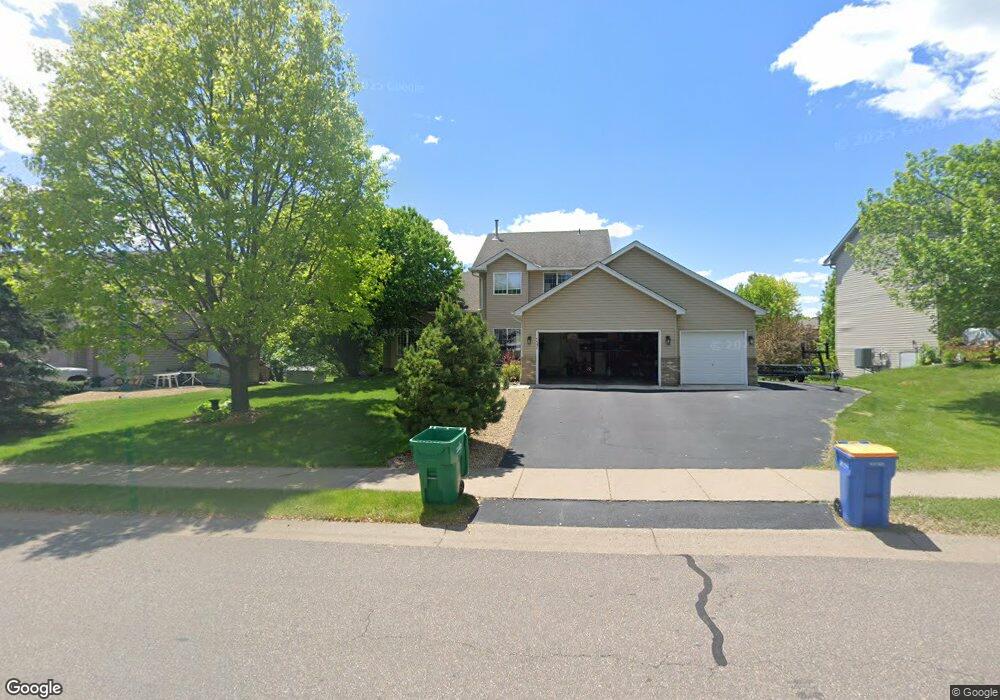
4533 Mayfield Ave NE Saint Michael, MN 55376
Estimated Value: $443,000 - $463,000
4
Beds
5
Baths
1,880
Sq Ft
$241/Sq Ft
Est. Value
About This Home
This home is located at 4533 Mayfield Ave NE, Saint Michael, MN 55376 and is currently estimated at $452,141, approximately $240 per square foot. 4533 Mayfield Ave NE is a home located in Wright County with nearby schools including Albertville Primary School, Big Woods Elementary School, and Middle School East.
Ownership History
Date
Name
Owned For
Owner Type
Purchase Details
Closed on
Jun 6, 2003
Sold by
Lalande Susan M and Lalande Stephen E
Bought by
National Residential Nominee Svcs Inc
Current Estimated Value
Purchase Details
Closed on
Aug 1, 2000
Sold by
Shade Tree Construction Inc
Bought by
Lalonde Stephen E and Lalonde Susan M
Purchase Details
Closed on
Apr 3, 2000
Sold by
Tsm Development Inc
Bought by
Shade Tree Construction Inc
Create a Home Valuation Report for This Property
The Home Valuation Report is an in-depth analysis detailing your home's value as well as a comparison with similar homes in the area
Home Values in the Area
Average Home Value in this Area
Purchase History
| Date | Buyer | Sale Price | Title Company |
|---|---|---|---|
| National Residential Nominee Svcs Inc | $245,900 | -- | |
| Lalonde Stephen E | $198,900 | -- | |
| Shade Tree Construction Inc | $37,900 | -- |
Source: Public Records
Tax History Compared to Growth
Tax History
| Year | Tax Paid | Tax Assessment Tax Assessment Total Assessment is a certain percentage of the fair market value that is determined by local assessors to be the total taxable value of land and additions on the property. | Land | Improvement |
|---|---|---|---|---|
| 2025 | $4,520 | $416,400 | $100,000 | $316,400 |
| 2024 | $4,464 | $402,600 | $95,000 | $307,600 |
| 2023 | $4,432 | $421,300 | $98,300 | $323,000 |
| 2022 | $4,360 | $388,900 | $91,000 | $297,900 |
| 2021 | $4,278 | $329,500 | $65,000 | $264,500 |
| 2020 | $4,286 | $314,100 | $60,000 | $254,100 |
| 2019 | $4,156 | $307,400 | $0 | $0 |
| 2018 | $3,826 | $284,000 | $0 | $0 |
| 2017 | $3,628 | $268,400 | $0 | $0 |
| 2016 | $3,474 | $0 | $0 | $0 |
| 2015 | $3,402 | $0 | $0 | $0 |
| 2014 | -- | $0 | $0 | $0 |
Source: Public Records
Map
Nearby Homes
- 12752 43rd St NE
- 2464 Jacamar Ave NE
- 12819 46th Cir NE
- 4850 Mcallister Ave NE
- 12930 44th Place Cir NE
- 12745 39th St NE
- 3896 Melby Ave NE
- 12801 40th St NE
- 11898 38th Place NE
- 3886 Larabee Ave NE
- 115xx 50th St NE
- 4505 Napier Pkwy NE
- 4566 Landmark Dr NE
- 911 Ridge Dr SE
- 3823 Larabee Ave NE
- 3773 Larabee Ave NE
- 709 Ridge Dr SE
- 4149 Orleans Dr NE
- 13442 44th Cir NE
- 13463 45th St NE
- 4545 Mayfield Ave NE
- 4435 Mayfield Ave NE
- 4565 Mayfield Ave NE
- 4423 Mayfield Ave NE
- 4434 Mason Ave NE
- 4546 Mayfield Ave NE
- 4534 Mayfield Ave NE
- 4522 Mayfield Ave NE
- 4446 Mason Ave NE
- 4558 Mayfield Ave NE
- 4422 Mason Ave NE
- 4424 Mayfield Ave NE
- 4411 Mayfield Ave NE
- 4570 Mayfield Ave NE
- 4554 Mayelin Ave NE
- 4576 Mayelin Ave NE
- 4532 Mayelin Ave NE
- 4510 Mayelin Ave NE
- 4410 Mason Ave NE
- 4458 Mayelin Ave NE