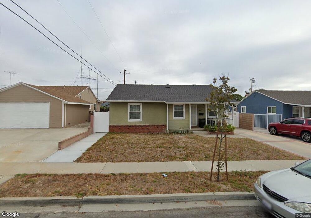
4535 Darien St Torrance, CA 90503
West Torrance NeighborhoodEstimated Value: $1,369,381 - $1,615,000
4
Beds
2
Baths
1,783
Sq Ft
$807/Sq Ft
Est. Value
About This Home
This home is located at 4535 Darien St, Torrance, CA 90503 and is currently estimated at $1,438,845, approximately $806 per square foot. 4535 Darien St is a home located in Los Angeles County with nearby schools including Towers Elementary School, Bert M. Lynn Middle School, and West High School.
Ownership History
Date
Name
Owned For
Owner Type
Purchase Details
Closed on
Jun 17, 2017
Sold by
Lin Carl C
Bought by
Lin Carl C and Lin Elaine Lienju
Current Estimated Value
Purchase Details
Closed on
Aug 21, 1997
Sold by
The Dalcin Family Trust
Bought by
Lin Chia Lo and Chang Lien Ju
Home Financials for this Owner
Home Financials are based on the most recent Mortgage that was taken out on this home.
Original Mortgage
$186,750
Outstanding Balance
$27,574
Interest Rate
7.37%
Estimated Equity
$1,411,271
Purchase Details
Closed on
Jun 3, 1997
Sold by
Yuge Thomas T
Bought by
Dalcin Darryle and Dalcin Wanda L
Create a Home Valuation Report for This Property
The Home Valuation Report is an in-depth analysis detailing your home's value as well as a comparison with similar homes in the area
Home Values in the Area
Average Home Value in this Area
Purchase History
| Date | Buyer | Sale Price | Title Company |
|---|---|---|---|
| Lin Carl C | -- | None Available | |
| Lin Chia Lo | $249,000 | -- | |
| Dalcin Darryle | $202,100 | First American |
Source: Public Records
Mortgage History
| Date | Status | Borrower | Loan Amount |
|---|---|---|---|
| Open | Lin Chia Lo | $186,750 |
Source: Public Records
Tax History Compared to Growth
Tax History
| Year | Tax Paid | Tax Assessment Tax Assessment Total Assessment is a certain percentage of the fair market value that is determined by local assessors to be the total taxable value of land and additions on the property. | Land | Improvement |
|---|---|---|---|---|
| 2025 | $6,255 | $540,835 | $318,064 | $222,771 |
| 2024 | $6,255 | $530,231 | $311,828 | $218,403 |
| 2023 | $6,141 | $519,835 | $305,714 | $214,121 |
| 2022 | $6,058 | $509,643 | $299,720 | $209,923 |
| 2021 | $5,943 | $499,651 | $293,844 | $205,807 |
| 2019 | $4,292 | $356,401 | $285,129 | $71,272 |
| 2018 | $4,115 | $349,414 | $279,539 | $69,875 |
| 2016 | $3,927 | $335,847 | $268,685 | $67,162 |
| 2015 | $3,841 | $330,804 | $264,650 | $66,154 |
| 2014 | $3,746 | $324,325 | $259,466 | $64,859 |
Source: Public Records
Map
Nearby Homes
- 20034 Grevillea Ave
- 20017 Bernist Ave
- 2905 Spreckels Ct
- 18801 Hawthorne Blvd Unit 19
- 20318 Regina Ave
- 2617 Alvord Ln
- 3564 Michelle Dr
- 19219 Beckworth Ave
- 2600 Alvord Ln
- 18406 Kingsdale Ave
- 18413 Burin Ave
- 20520 Earl St Unit 14
- 2708 184th St
- 19509 Hinsdale Ave
- 4489 Spencer St Unit 224
- 20515 Palm Way
- 2708 183rd St
- 20550 Earl St Unit 15
- 2519 Ralston Ln
- 18204 Kingsdale Ave