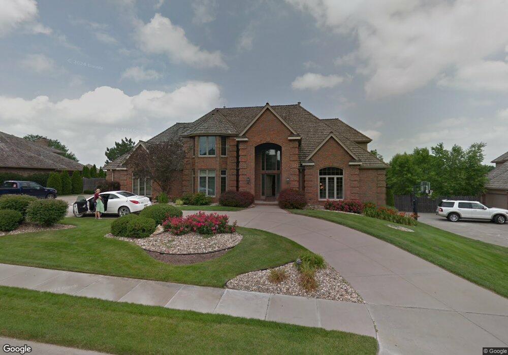
4535 S 162nd Ave Omaha, NE 68135
Prairie Pointe NeighborhoodEstimated Value: $978,802 - $1,040,000
5
Beds
5
Baths
7,044
Sq Ft
$142/Sq Ft
Est. Value
About This Home
This home is located at 4535 S 162nd Ave, Omaha, NE 68135 and is currently estimated at $997,951, approximately $141 per square foot. 4535 S 162nd Ave is a home located in Douglas County with nearby schools including Willowdale Elementary School, Russell Middle School, and Millard West High School.
Ownership History
Date
Name
Owned For
Owner Type
Purchase Details
Closed on
Dec 3, 2010
Sold by
Werner Becky K
Bought by
Jensen Mayda S and Jensen Robert C
Current Estimated Value
Create a Home Valuation Report for This Property
The Home Valuation Report is an in-depth analysis detailing your home's value as well as a comparison with similar homes in the area
Home Values in the Area
Average Home Value in this Area
Purchase History
| Date | Buyer | Sale Price | Title Company |
|---|---|---|---|
| Jensen Mayda S | $532,000 | Nlta |
Source: Public Records
Tax History Compared to Growth
Tax History
| Year | Tax Paid | Tax Assessment Tax Assessment Total Assessment is a certain percentage of the fair market value that is determined by local assessors to be the total taxable value of land and additions on the property. | Land | Improvement |
|---|---|---|---|---|
| 2025 | $13,214 | $812,800 | $195,300 | $617,500 |
| 2024 | $17,412 | $812,800 | $195,300 | $617,500 |
| 2023 | $17,412 | $874,600 | $195,300 | $679,300 |
| 2022 | $18,485 | $874,600 | $195,300 | $679,300 |
| 2021 | $14,726 | $700,400 | $195,300 | $505,100 |
| 2020 | $14,634 | $690,200 | $195,300 | $494,900 |
| 2019 | $14,678 | $690,200 | $195,300 | $494,900 |
| 2018 | $13,644 | $632,800 | $195,300 | $437,500 |
| 2017 | $12,439 | $632,800 | $195,300 | $437,500 |
| 2016 | $12,439 | $585,500 | $58,100 | $527,400 |
| 2015 | $11,867 | $547,200 | $54,300 | $492,900 |
| 2014 | $11,867 | $547,200 | $54,300 | $492,900 |
Source: Public Records
Map
Nearby Homes
- 16715 L St
- 16206 Orchard Cir
- 16767 J Cir
- 16508 Holmes St
- 4816 S 160th St
- 5025 S 163rd St
- 16904 L Cir
- 4955 Lakeshore Dr
- 16921 Patterson Dr
- 16217 Weir St
- 17023 Holmes Cir
- 5086 S 160th Cir
- 4629 S 155th Cir
- 15477 Stevens Plaza
- 5210 S 165th St
- 5018 S 169th Cir
- 16627 Weir St
- 17057 Orchard Ave
- 17063 Orchard Ave
- 5217 S 167th St
- 4525 S 162nd Ave
- 4545 S 162nd Ave
- 4545 S 162nd Ave
- 16252 K St
- 4515 S 162nd Ave
- 4607 S 162nd Ave
- 4534 S 162nd Ave
- 4524 S 162nd Ave
- 16260 K St
- 4514 S 162nd Ave
- 4505 S 162nd Ave
- 4615 S 162nd Ave
- 4531 S 163rd St
- 4608 S 162nd Ave
- 4521 S 163rd St
- 16268 K St
- 4504 S 162nd Ave
- 4511 S 163rd St
- 16261 K St
- 4425 S 162nd Ave