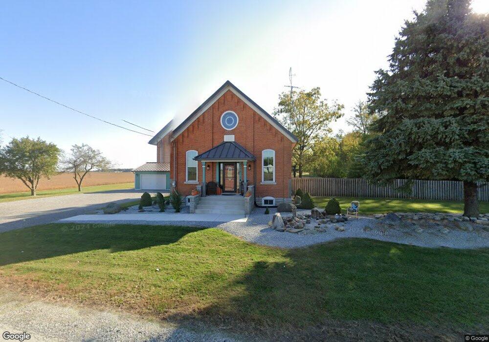
4538 State Route 364 Minster, OH 45865
Estimated Value: $191,000 - $322,000
2
Beds
1
Bath
1,176
Sq Ft
$221/Sq Ft
Est. Value
About This Home
This home is located at 4538 State Route 364, Minster, OH 45865 and is currently estimated at $260,008, approximately $221 per square foot. 4538 State Route 364 is a home located in Auglaize County with nearby schools including Marion Local Elementary School and Marion Local High School.
Ownership History
Date
Name
Owned For
Owner Type
Purchase Details
Closed on
Jun 21, 2004
Sold by
Zimmerman Shirley A
Bought by
Timmerman Eric T
Current Estimated Value
Purchase Details
Closed on
Jul 22, 2002
Sold by
Wehrkamp James J
Bought by
Zimmerman Shirley A
Purchase Details
Closed on
Mar 16, 1992
Sold by
Heitkamp Eugene
Bought by
Heitkamp James J
Create a Home Valuation Report for This Property
The Home Valuation Report is an in-depth analysis detailing your home's value as well as a comparison with similar homes in the area
Purchase History
| Date | Buyer | Sale Price | Title Company |
|---|---|---|---|
| Timmerman Eric T | $134,000 | -- | |
| Zimmerman Shirley A | $125,000 | -- | |
| Heitkamp James J | $5,000 | -- |
Source: Public Records
Tax History
| Year | Tax Paid | Tax Assessment Tax Assessment Total Assessment is a certain percentage of the fair market value that is determined by local assessors to be the total taxable value of land and additions on the property. | Land | Improvement |
|---|---|---|---|---|
| 2025 | $3,285 | $64,600 | $8,910 | $55,690 |
| 2024 | $3,285 | $64,600 | $8,910 | $55,690 |
| 2023 | $2,529 | $64,600 | $8,910 | $55,690 |
| 2022 | $2,019 | $49,420 | $8,100 | $41,320 |
| 2021 | $2,030 | $49,420 | $8,100 | $41,320 |
| 2020 | $2,038 | $49,417 | $8,099 | $41,318 |
| 2019 | $1,820 | $42,603 | $6,983 | $35,620 |
| 2018 | $1,878 | $42,603 | $6,983 | $35,620 |
| 2017 | $1,774 | $42,603 | $6,983 | $35,620 |
| 2016 | $1,684 | $40,541 | $6,650 | $33,891 |
| 2015 | $1,660 | $40,541 | $6,650 | $33,891 |
| 2014 | $1,662 | $40,541 | $6,650 | $33,891 |
| 2013 | $1,812 | $40,541 | $6,650 | $33,891 |
Source: Public Records
Map
Nearby Homes
- 2109 Thobe Ln
- 2102 Thobe Ln
- 2065 Thobe Ln
- 2079 Thobe Ln
- 2093 Thobe Ln
- 1991 Minster Egypt Pike
- 312 Margaret St
- 316 Margaret St
- 323 Margaret St
- 217 S Washington St
- 31 Melcher St
- 561 S Walnut St Unit Lot3
- 424 E Plum St
- 420 E Plum St
- 416 E Plum St
- 315 Mid Lane St
- 310 N Main St
- 410 E Cherry St
- 7 E 2nd St
- 249 E Monroe St
- 4394 State Route 364
- 891 Heitkamp Rd
- 876 Heitkamp Rd
- 871 Heitkamp Rd
- 846 Heitkamp Rd
- 825 Heitkamp Rd
- 824 Heitkamp Rd
- 813 Heitkamp Rd
- 786 Heitkamp Rd
- 4127 State Route 364
- 4107 State Route 364
- 658 Heitkamp Rd
- 606 Heitkamp Rd
- 1113 State Route 119
- 590 Heitkamp Rd
- 1291 State Route 119
- 1366 Amsterdam Rd
- 1320 State Route 119
- 466 Heitkamp Rd
- 1467 State Route 119
Your Personal Tour Guide
Ask me questions while you tour the home.