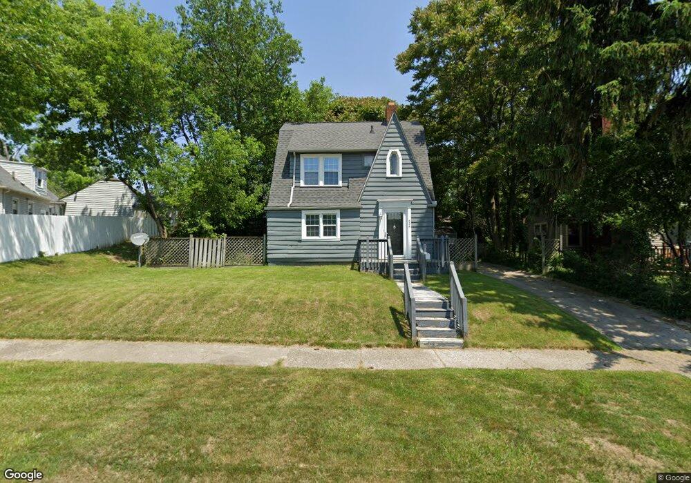
454 Dougherty Place Unit Bldg-Unit Flint, MI 48504
Mott Park NeighborhoodEstimated Value: $54,000 - $95,000
3
Beds
1
Bath
1,087
Sq Ft
$71/Sq Ft
Est. Value
About This Home
This home is located at 454 Dougherty Place Unit Bldg-Unit, Flint, MI 48504 and is currently estimated at $77,574, approximately $71 per square foot. 454 Dougherty Place Unit Bldg-Unit is a home located in Genesee County with nearby schools including Durant-Tuuri-Mott Elementary School, St John Vianney Catholic School, and St. Paul Lutheran School.
Ownership History
Date
Name
Owned For
Owner Type
Purchase Details
Closed on
Jan 21, 2020
Sold by
Laird Robert and Laird Jennifer A
Bought by
Otis Knows Llc
Current Estimated Value
Purchase Details
Closed on
Oct 31, 2018
Sold by
Wade Michkie K and Wade Marlando
Bought by
Laird Robert
Purchase Details
Closed on
Jan 21, 2011
Sold by
Perdue Sherry Wynn and Wynn Sherry L
Bought by
Wade Mickie K and Wade Marlando
Purchase Details
Closed on
May 28, 1999
Sold by
Coulter C E
Bought by
Wynn Sherry L
Create a Home Valuation Report for This Property
The Home Valuation Report is an in-depth analysis detailing your home's value as well as a comparison with similar homes in the area
Home Values in the Area
Average Home Value in this Area
Purchase History
| Date | Buyer | Sale Price | Title Company |
|---|---|---|---|
| Otis Knows Llc | -- | None Available | |
| Laird Robert | $31,000 | Sargents Title Co | |
| Wade Mickie K | $19,000 | Sterling Title Agency | |
| Wynn Sherry L | $81,000 | Cislo Title Company |
Source: Public Records
Tax History Compared to Growth
Tax History
| Year | Tax Paid | Tax Assessment Tax Assessment Total Assessment is a certain percentage of the fair market value that is determined by local assessors to be the total taxable value of land and additions on the property. | Land | Improvement |
|---|---|---|---|---|
| 2025 | $1,739 | $32,100 | $0 | $0 |
| 2024 | $1,597 | $33,900 | $0 | $0 |
| 2023 | $1,550 | $23,400 | $0 | $0 |
| 2022 | $0 | $18,700 | $0 | $0 |
| 2021 | $1,614 | $18,600 | $0 | $0 |
| 2020 | $1,029 | $18,200 | $0 | $0 |
| 2019 | $1,004 | $11,400 | $0 | $0 |
| 2018 | $774 | $10,700 | $0 | $0 |
| 2017 | $880 | $0 | $0 | $0 |
| 2016 | $880 | $0 | $0 | $0 |
| 2015 | -- | $0 | $0 | $0 |
| 2014 | -- | $0 | $0 | $0 |
| 2012 | -- | $17,700 | $0 | $0 |
Source: Public Records
Map
Nearby Homes
- 2329 Joliet St
- 448 Dougherty Place
- 2448 Thomas St
- 849 Frank St
- 2332 Nolen Dr
- 913 Perry St
- 820 N Chevrolet Ave
- 2539 Norbert St
- 2410 Sloan St
- 2553 Thomas St
- 1017 Perry St
- 2713 Norbert St
- 2536 Orchard Ln
- 1016 Dupont St
- 2008 University Ave
- 709 Cadillac St
- 1813 Stevenson St
- 3617 Sherwood Dr
- 1220 Forest Hill Ave
- 3119 Sherwood Dr
- 454 Dougherty Place
- 2313 Monteith St
- 460 Dougherty Place
- 2307 Monteith St
- 442 Dougherty Place
- 2301 Monteith St
- 436 Dougherty Place
- 2213 Cartier St
- 2209 Cartier St
- 2308 Monteith St
- 2314 Monteith St
- 430 Dougherty Place
- 2320 Monteith St
- 2302 Monteith St
- 2326 Monteith St
- 2205 Cartier St
- 2332 Monteith St
- 2201 Cartier St
- 502 Dougherty Place
- 2133 Cartier St