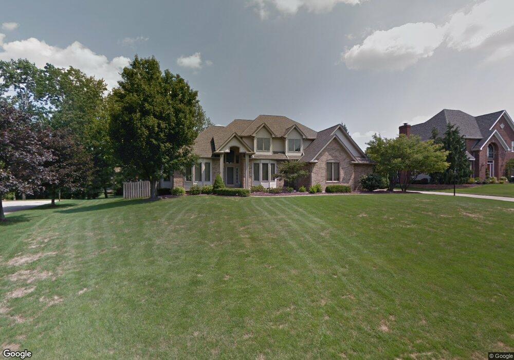
454 Presidential Ct Youngstown, OH 44512
Estimated Value: $441,000 - $474,323
4
Beds
3
Baths
3,069
Sq Ft
$147/Sq Ft
Est. Value
About This Home
This home is located at 454 Presidential Ct, Youngstown, OH 44512 and is currently estimated at $451,831, approximately $147 per square foot. 454 Presidential Ct is a home located in Mahoning County with nearby schools including Robinwood Lane Elementary School, Boardman Glenwood Junior High School, and Boardman High School.
Ownership History
Date
Name
Owned For
Owner Type
Purchase Details
Closed on
Nov 17, 2022
Sold by
Whitlinger Rose Ellen
Bought by
Myers Jennifer C and Myers Jeffrey D
Current Estimated Value
Purchase Details
Closed on
Dec 14, 2021
Sold by
Estate Of Gene Whitlinger
Bought by
Whitlinger Rose Ellen
Purchase Details
Closed on
Apr 26, 2021
Sold by
Whitlinger Paul W and Whitlinger Gene P
Bought by
Whitlinger Rose Ellen
Purchase Details
Closed on
Mar 18, 1993
Bought by
Whitlinger Gene and Whitlinger Loretta
Create a Home Valuation Report for This Property
The Home Valuation Report is an in-depth analysis detailing your home's value as well as a comparison with similar homes in the area
Home Values in the Area
Average Home Value in this Area
Purchase History
| Date | Buyer | Sale Price | Title Company |
|---|---|---|---|
| Myers Jennifer C | -- | -- | |
| Whitlinger Rose Ellen | -- | None Available | |
| Whitlinger Rose Ellen | -- | None Available | |
| Whitlinger Gene | $244,900 | -- |
Source: Public Records
Tax History Compared to Growth
Tax History
| Year | Tax Paid | Tax Assessment Tax Assessment Total Assessment is a certain percentage of the fair market value that is determined by local assessors to be the total taxable value of land and additions on the property. | Land | Improvement |
|---|---|---|---|---|
| 2024 | $7,355 | $144,450 | $21,600 | $122,850 |
| 2023 | $7,256 | $144,450 | $21,600 | $122,850 |
| 2022 | $6,678 | $101,580 | $17,280 | $84,300 |
| 2021 | $6,119 | $101,580 | $17,280 | $84,300 |
| 2020 | $6,150 | $101,580 | $17,280 | $84,300 |
| 2019 | $6,357 | $93,910 | $17,280 | $76,630 |
| 2018 | $5,501 | $93,910 | $17,280 | $76,630 |
| 2017 | $5,467 | $93,910 | $17,280 | $76,630 |
| 2016 | $5,491 | $93,840 | $15,740 | $78,100 |
| 2015 | $5,382 | $93,840 | $15,740 | $78,100 |
| 2014 | -- | $93,840 | $15,740 | $78,100 |
| 2013 | $5,330 | $93,840 | $15,740 | $78,100 |
Source: Public Records
Map
Nearby Homes
- 7708 Buchanan Dr
- 0 Saddlebrook Lot 123 Dr Unit 4442579
- 0 Saddlebrook Lot 153 Dr Unit 4442592
- 0 Saddlebrook Lot 156 Dr Unit 4442599
- 681 Saddlebrook Dr
- 912 Pearson Cir Unit 5
- 873 Auburn Hills Dr Unit 3
- 918 Pearson Cir Unit 4
- 7733 Crimson Trail Unit B
- 942 Pearson Cir Unit 4
- 829 Pearson Cir
- 816 Pearson Un#1
- 7368 Eisenhower Dr Unit 5
- 7680 Paulin Dr
- 8360 South Ave
- 7900 Walnut St Unit 25
- 8010 Sigle Ln
- 803 Terraview Dr
- 785 Terraview Dr
- 8129 South Ave
- 458 Presidential Ct
- 450 Presidential Ct
- 7670 Winterberry Dr
- 7678 Winterberry Dr
- 453 Presidential Ct
- 460 Presidential Ct
- 7662 Winterberry Dr
- 457 Presidential Ct
- 448 Presidential Ct
- 449 Presidential Ct
- 7686 Winterberry Dr
- 7654 Winterberry Dr
- 461 Presidential Ct
- 447 Presidential Ct
- 464 Presidential Ct
- 7748 Buchanan Dr
- 7638 Winterberry Dr
- 593 Presidential Dr
- 7646 Winterberry Dr
- 7738 Buchanan Dr