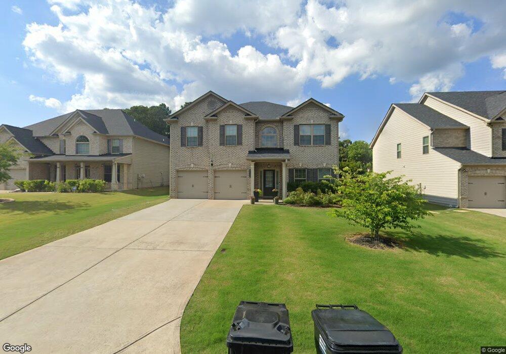
4545 Mossbrook Cir Alpharetta, GA 30004
Estimated Value: $630,662 - $667,000
4
Beds
3
Baths
3,013
Sq Ft
$216/Sq Ft
Est. Value
About This Home
This home is located at 4545 Mossbrook Cir, Alpharetta, GA 30004 and is currently estimated at $650,166, approximately $215 per square foot. 4545 Mossbrook Cir is a home with nearby schools including Sawnee Elementary School, Hendricks Middle School, and West Forsyth High School.
Ownership History
Date
Name
Owned For
Owner Type
Purchase Details
Closed on
Apr 26, 2024
Sold by
Welch Simpson Delia
Bought by
Welch Simpson Delia and Simpson Terrell L
Current Estimated Value
Purchase Details
Closed on
Sep 7, 2023
Sold by
Welch Simpson Delia
Bought by
Simpson Terrell L and Simpson Jazz Adar
Purchase Details
Closed on
Aug 30, 2016
Bought by
Simpson Delia Welch
Home Financials for this Owner
Home Financials are based on the most recent Mortgage that was taken out on this home.
Original Mortgage
$308,251
Interest Rate
3.43%
Mortgage Type
New Conventional
Create a Home Valuation Report for This Property
The Home Valuation Report is an in-depth analysis detailing your home's value as well as a comparison with similar homes in the area
Home Values in the Area
Average Home Value in this Area
Purchase History
| Date | Buyer | Sale Price | Title Company |
|---|---|---|---|
| Welch Simpson Delia | -- | None Listed On Document | |
| Simpson Terrell L | -- | None Listed On Document | |
| Simpson Delia Welch | $324,475 | -- |
Source: Public Records
Mortgage History
| Date | Status | Borrower | Loan Amount |
|---|---|---|---|
| Previous Owner | Simpson Delia Welch | $308,251 |
Source: Public Records
Tax History Compared to Growth
Tax History
| Year | Tax Paid | Tax Assessment Tax Assessment Total Assessment is a certain percentage of the fair market value that is determined by local assessors to be the total taxable value of land and additions on the property. | Land | Improvement |
|---|---|---|---|---|
| 2025 | $4,835 | $253,680 | $72,000 | $181,680 |
| 2024 | $4,835 | $230,832 | $64,000 | $166,832 |
| 2023 | $4,450 | $228,492 | $56,000 | $172,492 |
| 2022 | $4,440 | $145,032 | $40,000 | $105,032 |
| 2021 | $3,808 | $145,032 | $40,000 | $105,032 |
| 2020 | $3,644 | $137,048 | $40,000 | $97,048 |
| 2019 | $3,654 | $137,288 | $32,000 | $105,288 |
| 2018 | $3,448 | $127,848 | $32,000 | $95,848 |
| 2017 | $3,602 | $129,800 | $32,000 | $97,800 |
Source: Public Records
Map
Nearby Homes
- 4610 Mossbrook Cir
- 4465 Mossbrook Cir
- 4799 Drew Rd
- 4645 Hamptons Dr
- 7880 Brands Hatch Blvd
- 212 Silver Birch Ct
- 4750 Hamptons Dr
- 4810 Hamptons Club Dr
- 7619 Campground Rd
- 5055 Hamptons Club Dr
- 4235 Drew Campground Rd
- 3384 Holbrook Campground Rd
- 2687 Holbrook Campground Rd
- 2675 Holbrook Campground Rd
- 5385 Drew Rd
- 6645 Bentley Ridge Dr
- 4415 Indian Trace Dr
- 4555 Mossbrook Cir Unit 4
- 4555 Mossbrook Cir
- 4555 Mossbrook Cir
- 4535 Mossbrook Cir Unit 6
- 4535 Mossbrook Cir Unit 6
- 4535 Mossbrook Cir
- 4565 Mossbrook Cir Unit 3
- 4525 Mossbrook Cir
- 4525 Mossbrook Cir
- 4540 Mossbrook Cir
- 4540 Mossbrook Cir Unit 56
- 4510 Mossbrook Cir
- 4575 Mossbrook Cir Unit 2
- 4575 Mossbrook Cir Unit 2
- 4575 Mossbrook Cir
- 4575 Mossbrook Cir
- 4550 Mossbrook Cir
- 4550 Mossbrook Cir
- 4550 Mossbrook Cir Unit 65
- 4550 Mossbrook Cir