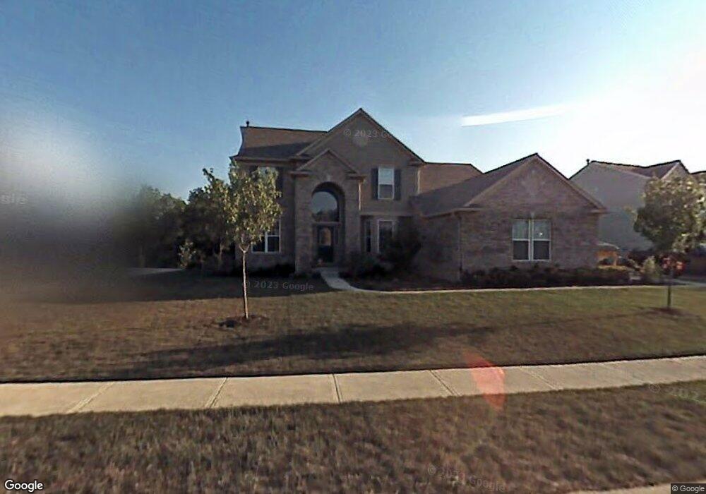
455 Raven Cir Brownsburg, IN 46112
Estimated Value: $453,000 - $557,000
4
Beds
3
Baths
2,560
Sq Ft
$203/Sq Ft
Est. Value
About This Home
This home is located at 455 Raven Cir, Brownsburg, IN 46112 and is currently estimated at $519,460, approximately $202 per square foot. 455 Raven Cir is a home located in Hendricks County with nearby schools including Eagle Elementary School, Brownsburg West Middle School, and Brownsburg High School.
Ownership History
Date
Name
Owned For
Owner Type
Purchase Details
Closed on
Jul 8, 2015
Sold by
Routh Gerald H and Routh Deborah K
Bought by
Nail Daniel L and Nail Megan E
Current Estimated Value
Home Financials for this Owner
Home Financials are based on the most recent Mortgage that was taken out on this home.
Original Mortgage
$350,000
Outstanding Balance
$274,426
Interest Rate
4.02%
Mortgage Type
New Conventional
Estimated Equity
$245,034
Create a Home Valuation Report for This Property
The Home Valuation Report is an in-depth analysis detailing your home's value as well as a comparison with similar homes in the area
Home Values in the Area
Average Home Value in this Area
Purchase History
| Date | Buyer | Sale Price | Title Company |
|---|---|---|---|
| Nail Daniel L | -- | Chicago Title |
Source: Public Records
Mortgage History
| Date | Status | Borrower | Loan Amount |
|---|---|---|---|
| Open | Nail Daniel L | $350,000 |
Source: Public Records
Tax History Compared to Growth
Tax History
| Year | Tax Paid | Tax Assessment Tax Assessment Total Assessment is a certain percentage of the fair market value that is determined by local assessors to be the total taxable value of land and additions on the property. | Land | Improvement |
|---|---|---|---|---|
| 2024 | $4,750 | $475,000 | $94,700 | $380,300 |
| 2023 | $4,359 | $435,900 | $86,000 | $349,900 |
| 2022 | $4,276 | $427,600 | $82,200 | $345,400 |
| 2021 | $3,797 | $379,700 | $77,300 | $302,400 |
| 2020 | $3,832 | $383,200 | $77,300 | $305,900 |
| 2019 | $3,663 | $366,300 | $72,500 | $293,800 |
| 2018 | $3,484 | $348,400 | $72,500 | $275,900 |
| 2017 | $3,308 | $330,800 | $69,000 | $261,800 |
| 2016 | $3,338 | $333,800 | $69,000 | $264,800 |
| 2014 | $3,211 | $321,100 | $66,400 | $254,700 |
| 2013 | $3,073 | $307,300 | $63,300 | $244,000 |
Source: Public Records
Map
Nearby Homes
- 1597 Redsunset Dr
- 5756 Foxfire Ln
- 6185 E US Highway 136
- 751 Fish Hawk Ct
- Glacier II Plan at Auburn Ridge - Legacy Series
- Ainsley II Plan at Auburn Ridge - Prestige Series
- Berkeley Basement Plan at Auburn Ridge - Prestige Series
- Kentmore Basement Plan at Auburn Ridge - Prestige Series
- Ainsley II Basement Plan at Auburn Ridge - Prestige Series
- Glendale Basement Plan at Auburn Ridge - Prestige Series
- Columbia Basement Plan at Auburn Ridge - Prestige Series
- Andes II Plan at Auburn Ridge - Legacy Series
- Cheswicke II Plan at Auburn Ridge - Prestige Series
- Drake Plan at Auburn Ridge - Prestige Series
- Olympic II Plan at Auburn Ridge - Legacy Series
- Cascade II Plan at Auburn Ridge - Legacy Series
- Drake Basement Plan at Auburn Ridge - Prestige Series
- Glendale Plan at Auburn Ridge - Prestige Series
- Kensington Plan at Auburn Ridge - Prestige Series
- Cheswicke II Basement Plan at Auburn Ridge - Prestige Series
- 457 Raven Cir
- 453 Raven Ct
- 459 Raven Cir
- 446 Raven Cir
- 451 Raven Ct
- 450 Raven Cir
- 445 Raven Ct
- 454 Raven Cir
- 449 Raven Ct
- 442 Letterman Dr
- 443 Letterman Dr
- 447 Raven Ct
- 1570 Midnight Pass
- 441 Letterman Dr
- 438 Letterman Dr
- 549 Raven Cir
- 439 Letterman Dr
- 434 Letterman Dr
- 1560 Midnight Pass
- 1561 Midnight Pass