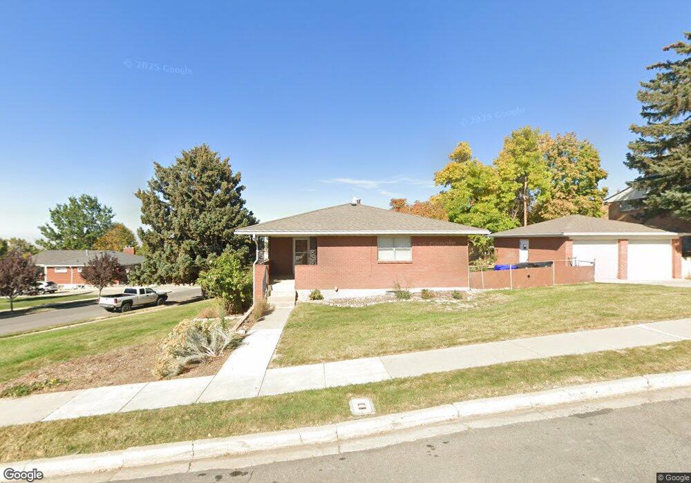
456 W 3500 S Bountiful, UT 84010
Estimated Value: $549,843 - $586,000
4
Beds
2
Baths
1,566
Sq Ft
$364/Sq Ft
Est. Value
About This Home
This home is located at 456 W 3500 S, Bountiful, UT 84010 and is currently estimated at $570,211, approximately $364 per square foot. 456 W 3500 S is a home located in Davis County with nearby schools including Adelaide School, South Davis Junior High School, and Woods Cross High School.
Ownership History
Date
Name
Owned For
Owner Type
Purchase Details
Closed on
Jan 7, 2011
Sold by
Langston Tory B and Langston Renae D
Bought by
Langston Renae D and Langston Tory B
Current Estimated Value
Home Financials for this Owner
Home Financials are based on the most recent Mortgage that was taken out on this home.
Original Mortgage
$100,000
Outstanding Balance
$2,171
Interest Rate
3.77%
Mortgage Type
New Conventional
Estimated Equity
$568,040
Purchase Details
Closed on
Oct 27, 2003
Sold by
Langston Troy B and Langston Renae D
Bought by
Langston Tory B and Langston Renae D
Purchase Details
Closed on
Nov 22, 2002
Sold by
Beavers Rowena E
Bought by
Langston Troy B and Langston Renae D
Home Financials for this Owner
Home Financials are based on the most recent Mortgage that was taken out on this home.
Original Mortgage
$120,000
Interest Rate
5.89%
Create a Home Valuation Report for This Property
The Home Valuation Report is an in-depth analysis detailing your home's value as well as a comparison with similar homes in the area
Home Values in the Area
Average Home Value in this Area
Purchase History
| Date | Buyer | Sale Price | Title Company |
|---|---|---|---|
| Langston Renae D | -- | Cornerstone Title Ins Ag | |
| Langston Tory B | -- | First American Title Co | |
| Langston Troy B | -- | First American Title Co |
Source: Public Records
Mortgage History
| Date | Status | Borrower | Loan Amount |
|---|---|---|---|
| Open | Langston Renae D | $100,000 | |
| Closed | Langston Troy B | $120,000 |
Source: Public Records
Tax History Compared to Growth
Tax History
| Year | Tax Paid | Tax Assessment Tax Assessment Total Assessment is a certain percentage of the fair market value that is determined by local assessors to be the total taxable value of land and additions on the property. | Land | Improvement |
|---|---|---|---|---|
| 2025 | $3,014 | $276,100 | $127,114 | $148,986 |
| 2024 | $2,860 | $266,199 | $114,005 | $152,194 |
| 2023 | $2,775 | $256,300 | $115,160 | $141,139 |
| 2022 | $2,880 | $494,000 | $207,703 | $286,297 |
| 2021 | $2,457 | $354,000 | $157,390 | $196,610 |
| 2020 | $2,232 | $323,000 | $134,191 | $188,809 |
| 2019 | $2,211 | $316,000 | $139,998 | $176,002 |
| 2018 | $2,074 | $292,000 | $137,192 | $154,808 |
| 2016 | $1,700 | $135,905 | $43,390 | $92,515 |
| 2015 | $1,680 | $126,995 | $43,390 | $83,605 |
| 2014 | $1,671 | $116,600 | $43,390 | $73,210 |
| 2013 | -- | $96,073 | $41,774 | $54,299 |
Source: Public Records
Map
Nearby Homes
- 3183 S 500 W
- 527 Applewood Dr
- 310 N 675 E
- 3238 S 675 W
- 2943 S 400 W
- 1036 E Fairway Dr
- 638 Scenic Hills Dr
- 178 N Valley View Dr
- 757 W 3200 S
- 1104 E Fairway Dr
- 90 Scenic Hills Cir
- 117 W 3000 S
- 8 E 3500 S
- 246 N Glenwood Way
- 53 N Foxhill Rd
- 93 N Valley View Dr
- 3463 S 50 E
- 626 Sagramore St
- 3573 S Highway 89
- 3474 S 100 E