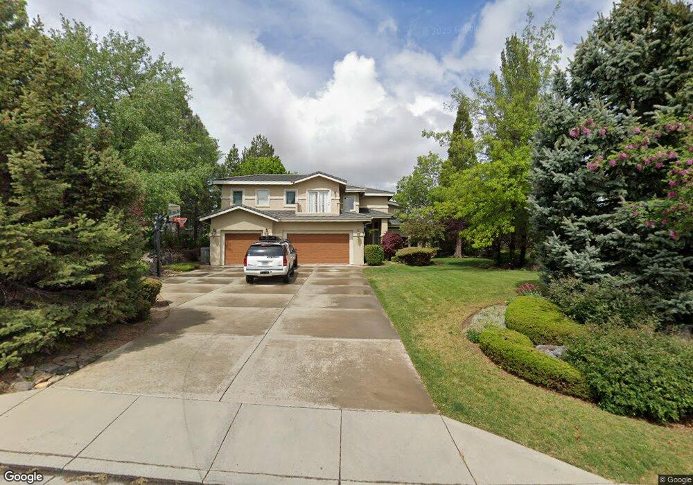
4560 Mountaingate Dr Unit 4 Reno, NV 89519
South Outer Reno NeighborhoodEstimated Value: $1,827,000 - $2,002,000
5
Beds
5
Baths
3,722
Sq Ft
$507/Sq Ft
Est. Value
About This Home
This home is located at 4560 Mountaingate Dr Unit 4, Reno, NV 89519 and is currently estimated at $1,885,926, approximately $506 per square foot. 4560 Mountaingate Dr Unit 4 is a home located in Washoe County with nearby schools including Roy Gomm Elementary School, Darrell C Swope Middle School, and Reno High School.
Ownership History
Date
Name
Owned For
Owner Type
Purchase Details
Closed on
Sep 6, 2024
Sold by
Freeman John A and Freeman Pamela C
Bought by
John And Pamela Freeman Family Trust and Freeman
Current Estimated Value
Purchase Details
Closed on
Feb 28, 2000
Sold by
Sierra Tahoe Homes Llc
Bought by
Freeman John A and Freeman Pamela C
Home Financials for this Owner
Home Financials are based on the most recent Mortgage that was taken out on this home.
Original Mortgage
$425,000
Interest Rate
8.16%
Purchase Details
Closed on
Jun 4, 1998
Sold by
Lawson Daryl Jay and Sladek Lawson Rosemarie
Bought by
Sierra Tahoe Homes Llc
Create a Home Valuation Report for This Property
The Home Valuation Report is an in-depth analysis detailing your home's value as well as a comparison with similar homes in the area
Home Values in the Area
Average Home Value in this Area
Purchase History
| Date | Buyer | Sale Price | Title Company |
|---|---|---|---|
| John And Pamela Freeman Family Trust | -- | None Listed On Document | |
| Freeman John A | $626,000 | First Centennial Title Co | |
| Sierra Tahoe Homes Llc | $83,500 | First American Title Co |
Source: Public Records
Mortgage History
| Date | Status | Borrower | Loan Amount |
|---|---|---|---|
| Previous Owner | Freeman John A | $425,000 |
Source: Public Records
Tax History Compared to Growth
Tax History
| Year | Tax Paid | Tax Assessment Tax Assessment Total Assessment is a certain percentage of the fair market value that is determined by local assessors to be the total taxable value of land and additions on the property. | Land | Improvement |
|---|---|---|---|---|
| 2025 | $11,175 | $407,435 | $112,000 | $295,435 |
| 2024 | $11,175 | $398,158 | $112,000 | $286,158 |
| 2023 | $10,416 | $375,566 | $105,000 | $270,566 |
| 2022 | $10,114 | $317,641 | $92,750 | $224,891 |
| 2021 | $9,823 | $303,351 | $78,750 | $224,601 |
| 2020 | $9,535 | $304,008 | $78,750 | $225,258 |
| 2019 | $9,254 | $291,598 | $70,000 | $221,598 |
| 2018 | $8,700 | $279,052 | $70,000 | $209,052 |
| 2017 | $8,447 | $279,412 | $70,000 | $209,412 |
| 2016 | $8,233 | $276,491 | $64,750 | $211,741 |
| 2015 | $8,221 | $253,027 | $39,235 | $213,792 |
| 2014 | $7,982 | $217,478 | $30,450 | $187,028 |
| 2013 | -- | $214,056 | $30,450 | $183,606 |
Source: Public Records
Map
Nearby Homes
- 4485 Mountaingate Dr
- 4305 Mountaingate Dr
- 4400 Mountaingate Dr
- 4595 Woodchuck Cir
- 4890 Woodchuck Cir Unit 3
- 4930 Woodchuck Cir Unit 4
- 4820 Woodchuck Cir Unit 2
- 4760 Woodchuck Cir Unit 1
- 7440 W 4th St Unit 7
- 7440 W 4th St Unit 46
- 7440 W 4th St Unit 35
- 5195 Canyon Dr
- 4895 Woodchuck Cir Unit 16
- 4825 Woodchuck Cir Unit 17
- 30 Francovich Ct
- 5045 Hunters Peak Rd Unit 13
- 4265 Hackamore Dr
- 4840 Keshmiri Place
- 4315 Water Hole Rd
- 4229 Christy Way
- 4550 Mountaingate Dr
- 4580 Mountaingate Dr
- 4540 Mountaingate Dr
- 4565 Mountaingate Dr
- 4555 Mountaingate Dr
- 4545 Mountaingate Dr
- 4575 Mountaingate Dr Unit 4
- 4590 Mountaingate Dr
- 4530 Mountaingate Dr
- 4535 Mountaingate Dr
- 4585 Mountaingate Dr
- 4600 Mountaingate Dr
- 4595 Mountaingate Dr Unit 4
- 4520 Mountaingate Dr
- 4610 Mountaingate Dr Unit 3
- 4515 Mountaingate Dr
- 4605 Mountaingate Dr Unit 3
- 4510 Mountaingate Dr Unit 4
- 4425 Starwood Ct
- 4435 Starwood Ct