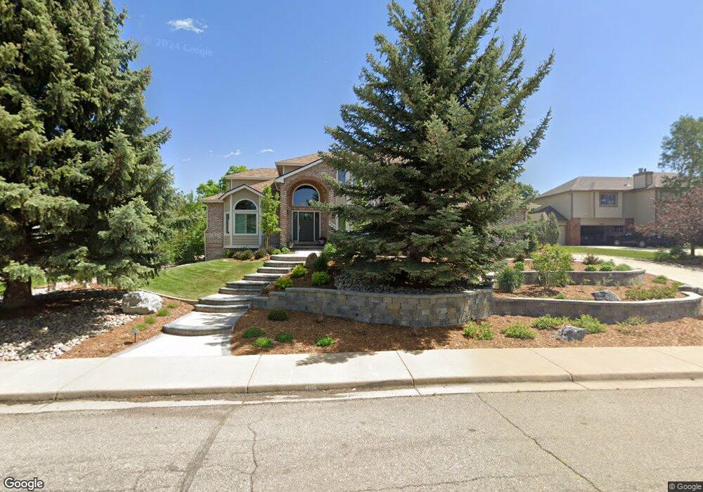
4561 Palmer Ct Longmont, CO 80503
Estimated Value: $1,126,948 - $1,513,000
4
Beds
3
Baths
2,993
Sq Ft
$444/Sq Ft
Est. Value
About This Home
This home is located at 4561 Palmer Ct, Longmont, CO 80503 and is currently estimated at $1,328,487, approximately $443 per square foot. 4561 Palmer Ct is a home located in Boulder County with nearby schools including Blue Mountain Elementary School, Altona Middle School, and Silver Creek High School.
Ownership History
Date
Name
Owned For
Owner Type
Purchase Details
Closed on
Apr 7, 1998
Sold by
Bero Deborah A and Bero Kenneth P
Bought by
Burnell Brenda J
Current Estimated Value
Home Financials for this Owner
Home Financials are based on the most recent Mortgage that was taken out on this home.
Original Mortgage
$416,250
Outstanding Balance
$79,501
Interest Rate
7.17%
Estimated Equity
$1,248,986
Purchase Details
Closed on
Sep 25, 1996
Sold by
Kroneberger Michael S and Kroneberger Keri L
Bought by
Bero Deborah A
Home Financials for this Owner
Home Financials are based on the most recent Mortgage that was taken out on this home.
Original Mortgage
$346,400
Interest Rate
7.87%
Purchase Details
Closed on
Aug 25, 1993
Bought by
Burnell Brenda J and Halperin Andrew F
Purchase Details
Closed on
Feb 8, 1993
Bought by
Burnell Brenda J and Halperin Andrew F
Create a Home Valuation Report for This Property
The Home Valuation Report is an in-depth analysis detailing your home's value as well as a comparison with similar homes in the area
Home Values in the Area
Average Home Value in this Area
Purchase History
| Date | Buyer | Sale Price | Title Company |
|---|---|---|---|
| Burnell Brenda J | $462,500 | -- | |
| Bero Deborah A | $433,000 | -- | |
| Burnell Brenda J | $314,500 | -- | |
| Burnell Brenda J | -- | -- |
Source: Public Records
Mortgage History
| Date | Status | Borrower | Loan Amount |
|---|---|---|---|
| Open | Burnell Brenda J | $416,250 | |
| Previous Owner | Bero Deborah A | $346,400 |
Source: Public Records
Tax History Compared to Growth
Tax History
| Year | Tax Paid | Tax Assessment Tax Assessment Total Assessment is a certain percentage of the fair market value that is determined by local assessors to be the total taxable value of land and additions on the property. | Land | Improvement |
|---|---|---|---|---|
| 2025 | $8,213 | $89,713 | $22,369 | $67,344 |
| 2024 | $8,213 | $89,713 | $22,369 | $67,344 |
| 2023 | $8,081 | $78,390 | $15,490 | $66,585 |
| 2022 | $7,688 | $70,660 | $12,461 | $58,199 |
| 2021 | $7,543 | $72,694 | $12,820 | $59,874 |
| 2020 | $6,017 | $58,087 | $18,948 | $39,139 |
| 2019 | $5,925 | $58,087 | $18,948 | $39,139 |
| 2018 | $5,582 | $55,030 | $16,560 | $38,470 |
| 2017 | $5,519 | $60,838 | $18,308 | $42,530 |
| 2016 | $5,286 | $51,740 | $15,761 | $35,979 |
| 2015 | $5,053 | $47,362 | $19,184 | $28,178 |
| 2014 | $5,060 | $47,362 | $19,184 | $28,178 |
Source: Public Records
Map
Nearby Homes
- 6798 Snead Ct
- 4448 Nicklaus Ct
- 6686 Fairways Dr
- 6668 Fairways Dr
- 4046 Niblick Dr
- 3900 Bogey Ct
- 7484 N 49th St
- 5196 Oxford Rd
- 8000 N 41st St
- 5939 Niwot Rd
- 7979 N 41st St
- 4937 Valkyrie Dr
- 4932 Valkyrie Dr
- 4963 Kelso Rd
- 5952 Oxford Rd
- 8602 N 39th St
- 8418 Stirrup Ln
- 8586 N 55th St
- 5124 N Foothills Hwy
- 8241 N Foothills Hwy
- 4579 Palmer Ct
- 4547 Palmer Ct
- 6768 Golf Club Dr
- 4601 Palmer Ct
- 6756 Golf Club Dr
- 4578 Palmer Ct
- 6780 Golf Club Dr
- 4560 Palmer Ct
- 4535 Palmer Ct
- 4600 Palmer Ct
- 4546 Palmer Ct
- 4617 Palmer Ct
- 6744 Golf Club Dr
- 6782 Golf Club Dr
- 4612 Palmer Ct
- 4540 Palmer Ct
- 6735 Snead Ct
- 4639 Palmer Ct
- 4519 Palmer Ct
- 6658 Snead Ct