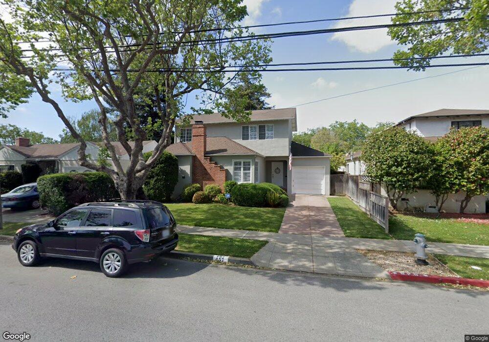
457 Bloomfield Rd Burlingame, CA 94010
Oak Grove Manor NeighborhoodEstimated Value: $2,532,000 - $3,498,000
3
Beds
2
Baths
2,170
Sq Ft
$1,330/Sq Ft
Est. Value
About This Home
This home is located at 457 Bloomfield Rd, Burlingame, CA 94010 and is currently estimated at $2,887,143, approximately $1,330 per square foot. 457 Bloomfield Rd is a home located in San Mateo County with nearby schools including Washington Elementary School, Burlingame Intermediate School, and Burlingame High School.
Ownership History
Date
Name
Owned For
Owner Type
Purchase Details
Closed on
Feb 22, 2023
Sold by
Wilson Blair Catherine
Bought by
Catherine W Blair Revocable Trust
Current Estimated Value
Purchase Details
Closed on
Apr 18, 2014
Sold by
Blair Catherine Wilson
Bought by
Blair Catherine Wilson
Purchase Details
Closed on
Mar 18, 2014
Sold by
Wilson John S
Bought by
Blair Catherine Wilson
Create a Home Valuation Report for This Property
The Home Valuation Report is an in-depth analysis detailing your home's value as well as a comparison with similar homes in the area
Home Values in the Area
Average Home Value in this Area
Purchase History
| Date | Buyer | Sale Price | Title Company |
|---|---|---|---|
| Catherine W Blair Revocable Trust | -- | -- | |
| Blair Catherine Wilson | -- | None Available | |
| Blair Catherine Wilson | -- | None Available |
Source: Public Records
Tax History
| Year | Tax Paid | Tax Assessment Tax Assessment Total Assessment is a certain percentage of the fair market value that is determined by local assessors to be the total taxable value of land and additions on the property. | Land | Improvement |
|---|---|---|---|---|
| 2025 | $4,934 | $414,826 | $139,868 | $274,958 |
| 2023 | $4,934 | $398,720 | $134,438 | $264,282 |
| 2022 | $4,841 | $390,902 | $131,802 | $259,100 |
| 2021 | $4,845 | $383,238 | $129,218 | $254,020 |
| 2020 | $4,747 | $379,310 | $127,894 | $251,416 |
| 2019 | $4,649 | $371,874 | $125,387 | $246,487 |
| 2018 | $4,565 | $364,583 | $122,929 | $241,654 |
| 2017 | $4,531 | $357,435 | $120,519 | $236,916 |
| 2016 | $4,366 | $350,427 | $118,156 | $232,271 |
| 2015 | $4,346 | $345,165 | $116,382 | $228,783 |
| 2014 | $4,285 | $338,405 | $114,103 | $224,302 |
Source: Public Records
Map
Nearby Homes
- 728 Laurel Ave
- 808 Winchester Dr
- 200 Anita Rd
- 748 Laurel Ave
- 737 Linden Ave
- 422 Peninsula Ave
- 320 Peninsula Ave Unit 409
- 320 Peninsula Ave Unit 316
- 39 Victoria Rd
- 869 Woodside Way
- 30 Lorton Ave Unit 302
- 1433 Floribunda Ave Unit 8
- 1433 Floribunda Ave Unit 5
- 1433 Floribunda Ave Unit 7
- 1433 Floribunda Ave Unit 1
- 10 Channing Rd
- 33 Park Rd Unit 5
- 525 Almer Rd Unit 106
- 839 Crossway Rd
- 815 N Humboldt St Unit 508
- 453 Bloomfield Rd
- 461 Bloomfield Rd
- 449 Bloomfield Rd
- 465 Bloomfield Rd
- 450 Cumberland Dr
- 452 Cumberland Dr
- 446 Cumberland Dr
- 469 Bloomfield Rd
- 456 Cumberland Dr
- 442 Cumberland Dr
- 450 Bloomfield Rd
- 460 Bloomfield Rd
- 704 Plymouth Way
- 700 Plymouth Way
- 462 Cumberland Dr
- 708 Plymouth Way
- 473 Bloomfield Rd
- 631 Trenton Way
- 632 Trenton Way
- 438 Cumberland Dr
Your Personal Tour Guide
Ask me questions while you tour the home.