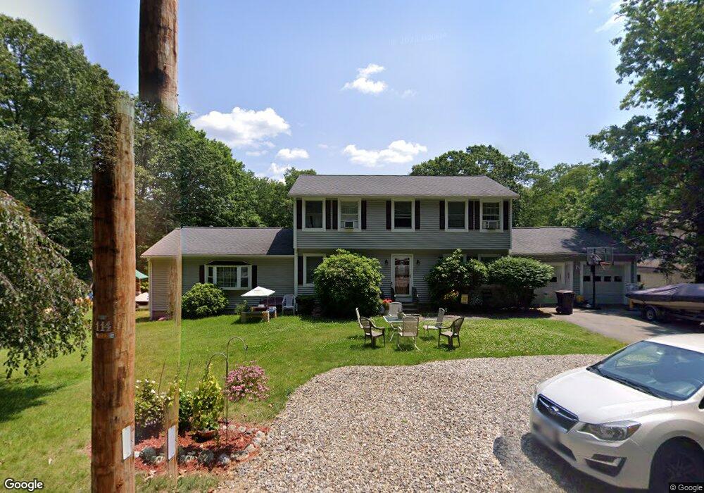
458 Leicester St Auburn, MA 01501
West Auburn NeighborhoodEstimated Value: $584,000 - $694,000
4
Beds
3
Baths
2,328
Sq Ft
$269/Sq Ft
Est. Value
About This Home
This home is located at 458 Leicester St, Auburn, MA 01501 and is currently estimated at $627,013, approximately $269 per square foot. 458 Leicester St is a home located in Worcester County with nearby schools including Auburn Senior High School and Shrewsbury Montessori School - Auburn Campus.
Ownership History
Date
Name
Owned For
Owner Type
Purchase Details
Closed on
Aug 30, 1996
Sold by
Tan Zhi Q and Zhou Li
Bought by
Morang Michael G and Morang Deborah
Current Estimated Value
Purchase Details
Closed on
May 1, 1989
Sold by
Morton James
Bought by
Tan Zhi Q
Purchase Details
Closed on
Nov 17, 1987
Sold by
Shannon Thomas F
Bought by
Aubu Custom Real Est
Create a Home Valuation Report for This Property
The Home Valuation Report is an in-depth analysis detailing your home's value as well as a comparison with similar homes in the area
Home Values in the Area
Average Home Value in this Area
Purchase History
| Date | Buyer | Sale Price | Title Company |
|---|---|---|---|
| Morang Michael G | $165,000 | -- | |
| Tan Zhi Q | $177,500 | -- | |
| Aubu Custom Real Est | $16,343 | -- |
Source: Public Records
Mortgage History
| Date | Status | Borrower | Loan Amount |
|---|---|---|---|
| Open | Aubu Custom Real Est | $150,000 | |
| Closed | Aubu Custom Real Est | $10,000 | |
| Closed | Aubu Custom Real Est | $125,000 |
Source: Public Records
Tax History Compared to Growth
Tax History
| Year | Tax Paid | Tax Assessment Tax Assessment Total Assessment is a certain percentage of the fair market value that is determined by local assessors to be the total taxable value of land and additions on the property. | Land | Improvement |
|---|---|---|---|---|
| 2025 | $72 | $505,400 | $124,500 | $380,900 |
| 2024 | $7,623 | $510,600 | $119,700 | $390,900 |
| 2023 | $7,271 | $457,900 | $108,900 | $349,000 |
| 2022 | $6,568 | $390,500 | $108,900 | $281,600 |
| 2021 | $1,155 | $352,800 | $96,700 | $256,100 |
| 2020 | $15,391 | $352,800 | $96,700 | $256,100 |
| 2019 | $6,136 | $333,100 | $95,000 | $238,100 |
| 2018 | $6,004 | $325,600 | $88,900 | $236,700 |
| 2017 | $5,819 | $317,300 | $80,600 | $236,700 |
| 2016 | $5,581 | $308,500 | $83,100 | $225,400 |
| 2015 | $4,836 | $280,200 | $83,100 | $197,100 |
| 2014 | $4,727 | $273,400 | $79,400 | $194,000 |
Source: Public Records
Map
Nearby Homes
- 707 Stafford St
- Lot 2 Leicester St
- 1 Crowl Hill Rd
- 7 Sara Dr
- 88 Wallace Ave
- 285 Henshaw St
- 28 Lorna Dr
- 37 Inwood Rd
- 30 Briarcliff Dr
- 6 Ryans Way Unit 6
- 3 Old Cart Rd
- 19-20 Williams St
- 5 Virginia Dr Unit 5B
- 26 Burnett St
- 620 Henshaw St
- 177 Oxford St N
- 6 Pitcairn Ave
- 164 Peter Salem Rd
- 16 Homestead Ave
- 381 Oxford St N
- 456 Leicester St
- 460 Leicester St
- 455 Leicester St
- 450 Leicester St
- 462 Leicester St
- 447 Leicester St
- 461 Leicester St
- 461 Leicester St Unit 1
- 445 Leicester St
- 444 Leicester St
- 443 Leicester St
- 442 Leicester St
- 441 Leicester St
- 438 Leicester St
- 436 Leicester St
- 434 Leicester St
- 476 Leicester St
- 432 Leicester St
- 428 Leicester St
- 433 Leicester St