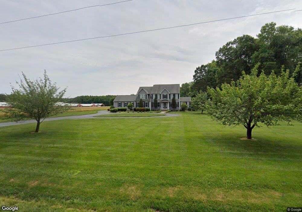
4580 Brownsville Rd Unit 1 Harrington, DE 19952
Estimated Value: $689,000 - $945,000
4
Beds
3
Baths
4,500
Sq Ft
$170/Sq Ft
Est. Value
About This Home
This home is located at 4580 Brownsville Rd Unit 1, Harrington, DE 19952 and is currently estimated at $763,059, approximately $169 per square foot. 4580 Brownsville Rd Unit 1 is a home located in Kent County with nearby schools including Lake Forest South Elementary School, Lake Forest Central Elementary School, and W.T. Chipman Middle School.
Ownership History
Date
Name
Owned For
Owner Type
Purchase Details
Closed on
Jun 21, 2016
Sold by
Darrin Simpson
Bought by
Kirby Russell and Kirby Kara
Current Estimated Value
Home Financials for this Owner
Home Financials are based on the most recent Mortgage that was taken out on this home.
Original Mortgage
$400,000
Outstanding Balance
$318,044
Interest Rate
3.54%
Estimated Equity
$445,015
Purchase Details
Closed on
Feb 9, 2005
Sold by
Shultie Hart Ellen M
Bought by
Simpson Darrin and Simpson Laura
Home Financials for this Owner
Home Financials are based on the most recent Mortgage that was taken out on this home.
Original Mortgage
$280,000
Interest Rate
5.83%
Mortgage Type
FHA
Create a Home Valuation Report for This Property
The Home Valuation Report is an in-depth analysis detailing your home's value as well as a comparison with similar homes in the area
Home Values in the Area
Average Home Value in this Area
Purchase History
| Date | Buyer | Sale Price | Title Company |
|---|---|---|---|
| Kirby Russell | -- | -- | |
| Simpson Darrin | -- | None Available |
Source: Public Records
Mortgage History
| Date | Status | Borrower | Loan Amount |
|---|---|---|---|
| Open | Kirby Russell | $400,000 | |
| Closed | Kirby Russell | -- | |
| Previous Owner | Simpson Darrin | $280,000 |
Source: Public Records
Tax History Compared to Growth
Tax History
| Year | Tax Paid | Tax Assessment Tax Assessment Total Assessment is a certain percentage of the fair market value that is determined by local assessors to be the total taxable value of land and additions on the property. | Land | Improvement |
|---|---|---|---|---|
| 2025 | $2,632 | $717,900 | $190,900 | $527,000 |
| 2024 | $2,632 | $717,900 | $190,900 | $527,000 |
| 2023 | $2,895 | $120,600 | $14,200 | $106,400 |
| 2022 | $2,591 | $120,600 | $14,200 | $106,400 |
| 2021 | $2,452 | $120,600 | $14,200 | $106,400 |
| 2020 | $2,557 | $120,600 | $14,200 | $106,400 |
| 2019 | $2,560 | $120,600 | $14,200 | $106,400 |
| 2018 | $2,520 | $120,600 | $14,200 | $106,400 |
| 2017 | $2,562 | $117,800 | $0 | $0 |
| 2016 | $2,347 | $117,800 | $0 | $0 |
| 2015 | $2,310 | $117,800 | $0 | $0 |
| 2014 | $2,276 | $117,800 | $0 | $0 |
Source: Public Records
Map
Nearby Homes
- 480 Hemping Rd
- 170 Sugar Stick Rd
- 590 Lobo Rd
- 2235 Vernon Rd
- 442 Melrose St
- 1008 Redwood Ct
- 123 W Mispillion St
- 21 W Mispillion St
- 219 S West St
- 223 Commerce St
- 104 Wolcott St
- 1 W Liberty St
- 112 Dorman St
- 205 Harrington Ave
- 2 Ward St
- 205 Delaware Ave
- Lot TBD Harrington Ave
- 115 East St
- 304 Second Ave
- 66 Meadow Wood Ln
- 4580 Brownsville Rd
- 4536 Brownsville Rd
- 4564 Brownsville Rd
- 4490 Brownsville Rd
- 4452 Brownsville Rd Unit 87335
- 4452 Brownsville Rd
- 4666 Brownsville Rd
- 4386 Brownsville Rd
- 4439 Brownsville Rd
- 1994 Fox Hunters Rd
- 1904 Fox Hunters Rd
- 2173 Fox Hunters Rd
- 2167 Fox Hunters Rd
- 1 Fox Hunters Rd
- 2475 Fox Hunters Rd
- 4175 Brownsville Rd
- 2343 Fox Hunters Rd
- 1731 Fox Hunters Rd
- 5023 Brownsville Rd
- 4071 Brownsville Rd