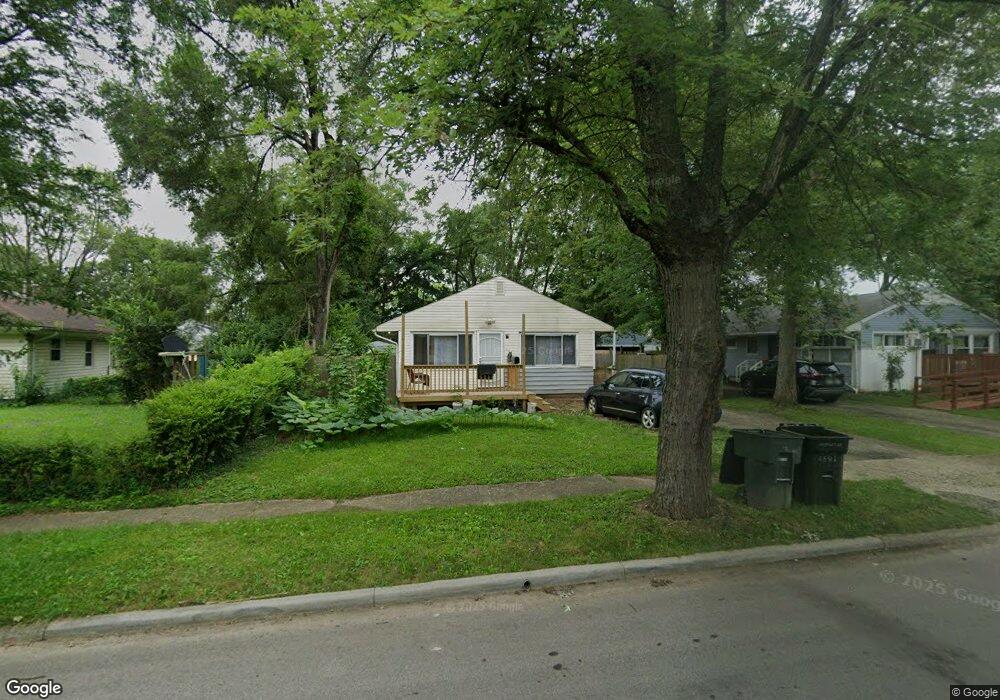
4591 Amesbury Rd Columbus, OH 43227
Shady Lane NeighborhoodEstimated Value: $178,431 - $240,000
3
Beds
1
Bath
1,056
Sq Ft
$194/Sq Ft
Est. Value
About This Home
This home is located at 4591 Amesbury Rd, Columbus, OH 43227 and is currently estimated at $205,358, approximately $194 per square foot. 4591 Amesbury Rd is a home located in Franklin County with nearby schools including Shady Lane Elementary School, Sherwood Middle School, and Walnut Ridge High School.
Ownership History
Date
Name
Owned For
Owner Type
Purchase Details
Closed on
Mar 1, 2022
Sold by
Moore Investments 3 Llc
Bought by
Perez Eloisa Gonzalez
Current Estimated Value
Purchase Details
Closed on
Feb 28, 2022
Sold by
Moore Investments 3 Llc
Bought by
Perez Eloisa Gonzalez
Purchase Details
Closed on
Feb 8, 2022
Sold by
Moore Investments 3 Llc
Bought by
Perez Eloisa Gonzalez
Purchase Details
Closed on
Jul 29, 2005
Sold by
Moore Douglas L and Sutton Lynne M
Bought by
Moore Investments 3 Llc
Purchase Details
Closed on
Feb 7, 1994
Bought by
Moore Douglas
Purchase Details
Closed on
May 1, 1985
Create a Home Valuation Report for This Property
The Home Valuation Report is an in-depth analysis detailing your home's value as well as a comparison with similar homes in the area
Home Values in the Area
Average Home Value in this Area
Purchase History
| Date | Buyer | Sale Price | Title Company |
|---|---|---|---|
| Perez Eloisa Gonzalez | $60,000 | Budde Joseph E | |
| Perez Eloisa Gonzalez | $60,000 | Budde Joseph E | |
| Perez Eloisa Gonzalez | $60,000 | Budde Joseph E | |
| Moore Investments 3 Llc | -- | -- | |
| Moore Douglas | $41,500 | -- | |
| -- | -- | -- |
Source: Public Records
Tax History
| Year | Tax Paid | Tax Assessment Tax Assessment Total Assessment is a certain percentage of the fair market value that is determined by local assessors to be the total taxable value of land and additions on the property. | Land | Improvement |
|---|---|---|---|---|
| 2025 | $2,545 | $56,700 | $16,170 | $40,530 |
| 2024 | $2,545 | $56,700 | $16,170 | $40,530 |
| 2023 | $2,512 | $56,700 | $16,170 | $40,530 |
| 2022 | $1,390 | $26,150 | $6,060 | $20,090 |
| 2021 | $1,405 | $26,150 | $6,060 | $20,090 |
| 2020 | $1,394 | $26,150 | $6,060 | $20,090 |
| 2019 | $1,280 | $20,590 | $4,870 | $15,720 |
| 2018 | $1,260 | $20,590 | $4,870 | $15,720 |
| 2017 | $1,280 | $20,590 | $4,870 | $15,720 |
| 2016 | $1,365 | $20,090 | $4,760 | $15,330 |
| 2015 | $1,243 | $20,090 | $4,760 | $15,330 |
| 2014 | $1,246 | $20,090 | $4,760 | $15,330 |
| 2013 | $723 | $23,625 | $5,600 | $18,025 |
Source: Public Records
Map
Nearby Homes
- 1284 Thurston Dr
- 1243 Simpson Dr
- 1229 Simpson Dr
- 4467 Grimsby Rd
- 1281 Maetzel Dr
- 1193 Marble Dr
- 4472 Aragon Ave
- 4677 E Livingston Ave
- 1356 Harlow Rd
- 1612 Simpson Dr
- 4859 Folger Dr
- 1607 Baxter Dr
- 1639 Shady Lane Rd
- 1260 Country Club Rd
- 4701 Janis Dr
- 1301 Bernhard Rd
- 1691 Shady Lane Rd
- 4649 Dundee Ave
- 1085 S Hamilton Rd
- 1472 Blaine Dr
- 4583 Amesbury Rd
- 1355 Simpson Dr
- 1365 Simpson Dr
- 4575 Amesbury Rd
- 4588 Rodney Rd
- 4580 Rodney Rd
- 4572 Rodney Rd
- 4598 Amesbury Rd
- 4569 Amesbury Rd
- 4586 Amesbury Rd
- 4596 Rodney Rd
- 4564 Rodney Rd
- 4578 Amesbury Rd
- 1325 Simpson Dr
- 4561 Amesbury Rd
- 4621 Amesbury Rd
- 1364 Simpson Dr
- 4556 Rodney Rd
- 4570 Amesbury Rd
- 1372 Simpson Dr
Your Personal Tour Guide
Ask me questions while you tour the home.