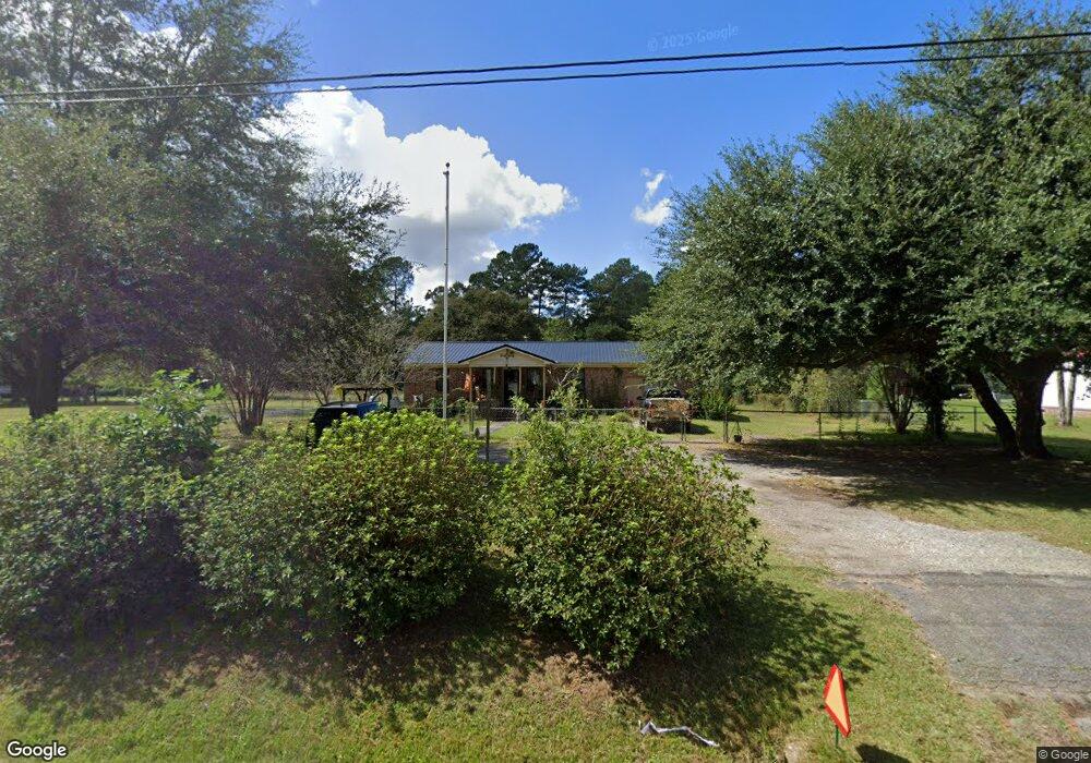
4595 Kent Rd Andrews, SC 29510
Estimated Value: $165,000 - $186,000
--
Bed
2
Baths
1,160
Sq Ft
$150/Sq Ft
Est. Value
About This Home
This home is located at 4595 Kent Rd, Andrews, SC 29510 and is currently estimated at $173,426, approximately $149 per square foot. 4595 Kent Rd is a home located in Georgetown County with nearby schools including Andrews Elementary School, Rosemary Middle School, and Andrews High School.
Ownership History
Date
Name
Owned For
Owner Type
Purchase Details
Closed on
May 22, 2015
Sold by
Knight Johnny Alan
Bought by
Knight Michael Edward
Current Estimated Value
Home Financials for this Owner
Home Financials are based on the most recent Mortgage that was taken out on this home.
Original Mortgage
$51,221
Outstanding Balance
$18,489
Interest Rate
3.03%
Mortgage Type
Future Advance Clause Open End Mortgage
Estimated Equity
$154,937
Purchase Details
Closed on
Feb 4, 2015
Sold by
Estate Of Jeanette R Knight and Knight Michael Edward
Bought by
Knight Michael Edward and Knight Johnny Alan
Purchase Details
Closed on
Dec 29, 2014
Sold by
Estate Of Jeanette R Knight and Knight William E
Bought by
Knight Michale E and Knight Johnny A
Purchase Details
Closed on
Oct 1, 2009
Sold by
Estate Of William G Knight and Knight Jeanette R
Bought by
Knight Jeanette R
Create a Home Valuation Report for This Property
The Home Valuation Report is an in-depth analysis detailing your home's value as well as a comparison with similar homes in the area
Home Values in the Area
Average Home Value in this Area
Purchase History
| Date | Buyer | Sale Price | Title Company |
|---|---|---|---|
| Knight Michael Edward | $35,000 | -- | |
| Knight Michael Edward | -- | -- | |
| Knight Michale E | -- | -- | |
| Knight Jeanette R | -- | -- |
Source: Public Records
Mortgage History
| Date | Status | Borrower | Loan Amount |
|---|---|---|---|
| Open | Knight Michael Edward | $51,221 |
Source: Public Records
Tax History Compared to Growth
Tax History
| Year | Tax Paid | Tax Assessment Tax Assessment Total Assessment is a certain percentage of the fair market value that is determined by local assessors to be the total taxable value of land and additions on the property. | Land | Improvement |
|---|---|---|---|---|
| 2024 | $565 | $5,250 | $560 | $4,690 |
| 2023 | $565 | $5,250 | $560 | $4,690 |
| 2022 | $527 | $5,250 | $560 | $4,690 |
| 2021 | $515 | $5,248 | $560 | $4,688 |
| 2020 | $514 | $5,248 | $560 | $4,688 |
| 2019 | $509 | $5,228 | $560 | $4,668 |
| 2018 | $521 | $52,280 | $0 | $0 |
| 2017 | $390 | $52,240 | $0 | $0 |
| 2016 | $624 | $5,224 | $0 | $0 |
| 2015 | -- | $0 | $0 | $0 |
| 2014 | -- | $126,500 | $14,000 | $112,500 |
| 2012 | -- | $126,500 | $14,000 | $112,500 |
Source: Public Records
Map
Nearby Homes
- 160 Leadwood St
- 85 Blackjack Ln
- 575 Green Bay Dr
- 12155 Gapway Rd
- 7.90 Acres-TBD Puncheon Creek Dr
- 793 Puncheon Creek Dr
- 73 Newton Trail
- 53 Newton Trail
- 43 Newton Trail
- 23 Newton Trail
- 23 Newton Trail Unit 23, 33, 43, 53, 73 N
- 33 Newton Trail
- 141 Feather Dr
- 121 Feather Dr
- 101 Feather Dr
- 754 Kent Rd
- 0 Rd
- 435 Alligator Ln
- 8 Clair St
- 8946 Highmarket St