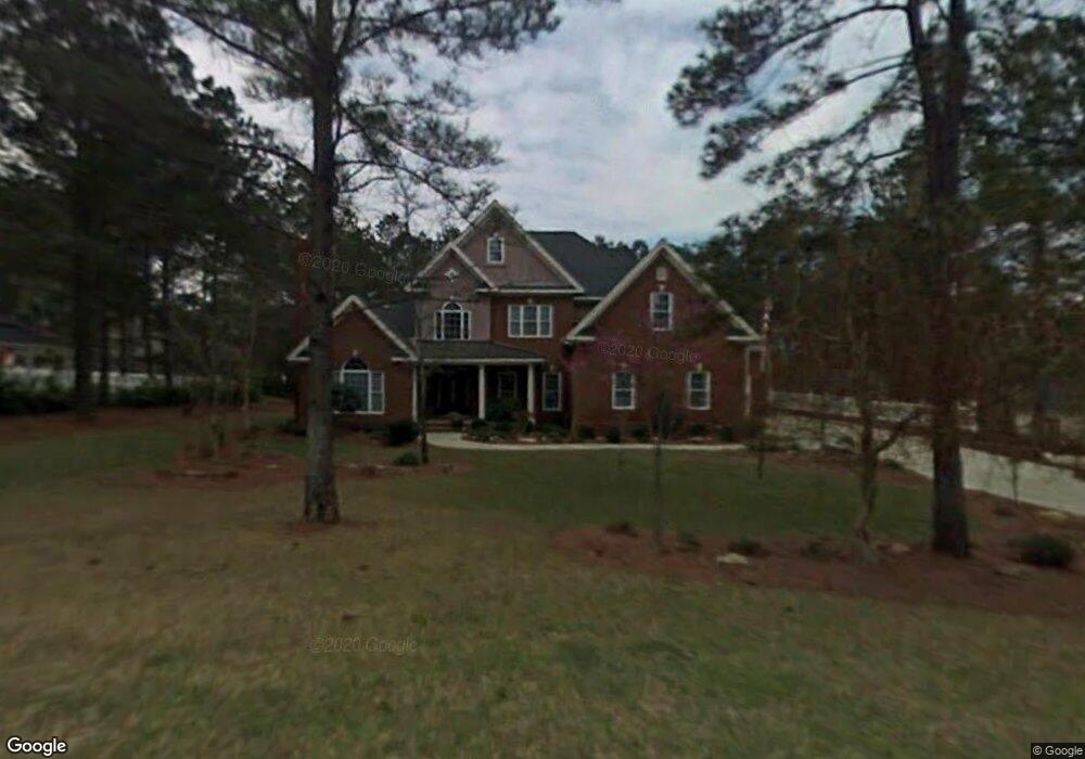
4595 Tillman Bluff Rd Valdosta, GA 31602
Estimated Value: $667,854 - $744,000
5
Beds
5
Baths
4,255
Sq Ft
$169/Sq Ft
Est. Value
About This Home
This home is located at 4595 Tillman Bluff Rd, Valdosta, GA 31602 and is currently estimated at $717,214, approximately $168 per square foot. 4595 Tillman Bluff Rd is a home located in Lowndes County with nearby schools including Westside Elementary School, Hahira Middle School, and Lowndes High School.
Ownership History
Date
Name
Owned For
Owner Type
Purchase Details
Closed on
Jan 23, 2017
Sold by
Delaney Michael
Bought by
Wilbanks Jammie and Wilbanks John
Current Estimated Value
Home Financials for this Owner
Home Financials are based on the most recent Mortgage that was taken out on this home.
Original Mortgage
$308,000
Outstanding Balance
$255,114
Interest Rate
4.3%
Mortgage Type
New Conventional
Estimated Equity
$462,100
Purchase Details
Closed on
Aug 12, 2011
Sold by
Hale Jeffrey L
Bought by
Delaney Michael and Delaney Heather H
Home Financials for this Owner
Home Financials are based on the most recent Mortgage that was taken out on this home.
Original Mortgage
$350,000
Interest Rate
4.54%
Mortgage Type
New Conventional
Purchase Details
Closed on
Feb 20, 2002
Sold by
Tillman Development Corp
Bought by
Hale Jeffrey L
Purchase Details
Closed on
Feb 18, 1993
Bought by
Tillman Development Corp
Create a Home Valuation Report for This Property
The Home Valuation Report is an in-depth analysis detailing your home's value as well as a comparison with similar homes in the area
Home Values in the Area
Average Home Value in this Area
Purchase History
| Date | Buyer | Sale Price | Title Company |
|---|---|---|---|
| Wilbanks Jammie | $385,000 | -- | |
| Delaney Michael | $437,500 | -- | |
| Hale Jeffrey L | $35,000 | -- | |
| Tillman Development Corp | -- | -- |
Source: Public Records
Mortgage History
| Date | Status | Borrower | Loan Amount |
|---|---|---|---|
| Open | Wilbanks Jammie | $308,000 | |
| Previous Owner | Delaney Michael | $350,000 |
Source: Public Records
Tax History Compared to Growth
Tax History
| Year | Tax Paid | Tax Assessment Tax Assessment Total Assessment is a certain percentage of the fair market value that is determined by local assessors to be the total taxable value of land and additions on the property. | Land | Improvement |
|---|---|---|---|---|
| 2024 | $6,719 | $246,525 | $18,000 | $228,525 |
| 2023 | $5,738 | $235,410 | $18,000 | $217,410 |
| 2022 | $4,734 | $175,815 | $18,000 | $157,815 |
| 2021 | $4,944 | $175,815 | $18,000 | $157,815 |
| 2020 | $4,592 | $175,815 | $18,000 | $157,815 |
| 2019 | $4,640 | $175,815 | $18,000 | $157,815 |
| 2018 | $4,688 | $175,815 | $18,000 | $157,815 |
| 2017 | $4,220 | $156,385 | $18,000 | $138,385 |
| 2016 | $4,231 | $156,385 | $18,000 | $138,385 |
| 2015 | $4,053 | $156,385 | $18,000 | $138,385 |
| 2014 | $4,137 | $156,385 | $18,000 | $138,385 |
Source: Public Records
Map
Nearby Homes
- 4850 Oak Arbor Dr
- 4849 Oak Arbor Dr
- 4715 Misty Valley Cir
- 4616 Rain Wood Cir
- 4837 Oak Arbor Dr
- 4715 Woodland Point
- 4632 Ridgeview Cir
- 4728 Woodland Point
- 4438 Huntington Pointe
- 4268 Deercrest Dr
- 4214 Oak Forest Dr
- 4082 Northlake Dr
- 4153 Springruff Dr
- 4267 Whisperwood Cir
- 4312 Wisteria Ln
- 4900 Tillman Crossing
- 4593 San Saba Dr
- 5041 Carlton Ridge Cir
- 5109 Village Way
- 0 Dasher Grove Rd
- 4599 Tillman Bluff Rd
- 4600 Oak Arbor Dr
- 4604 Oak Arbor Dr
- 4727 Misty Valley Cir
- 4598 Tillman Bluff Rd
- 4608 Oak Arbor Dr
- 4731 Misty Valley Cir
- 4723 Misty Valley Cir
- 4602 Tillman Bluff Rd
- 4846 Oak Arbor Dr
- 4612 Oak Arbor Dr
- 4585 Tillman Bluff Rd
- 4607 Tillman Bluff Rd
- 4605 Oak Arbor Dr
- 5705 Misty Valley Cir
- 4842 Oak Arbor Dr
- 4606 Tillman Bluff Rd
- 4735 Misty Valley Cir
- 4609 Oak Arbor Dr
- 4719 Misty Valley Cir