Estimated Value: $289,000 - $403,000
4
Beds
2
Baths
1,764
Sq Ft
$206/Sq Ft
Est. Value
About This Home
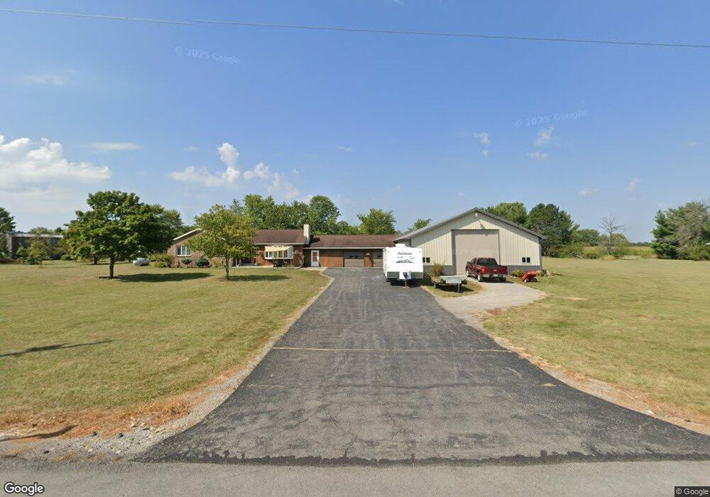
This home is located at 4599 Sandy Point Rd, Lima, OH 45807 and is currently estimated at $363,860, approximately $206 per square foot. 4599 Sandy Point Rd is a home located in Allen County with nearby schools including Elida Elementary School, Elida Middle School, and Elida High School.
Ownership History
Date
Name
Owned For
Owner Type
Purchase Details
Closed on
Nov 30, 2012
Sold by
Tyrrell Alan D and Tyrrell Bethany A
Bought by
Cruikshank William Wesley and Cruikshank Jessica Lynn
Current Estimated Value
Home Financials for this Owner
Home Financials are based on the most recent Mortgage that was taken out on this home.
Original Mortgage
$100,000
Outstanding Balance
$69,218
Interest Rate
3.35%
Mortgage Type
Future Advance Clause Open End Mortgage
Estimated Equity
$294,642
Purchase Details
Closed on
May 24, 2005
Sold by
Montooth Darlene
Bought by
Tyrrell Alan D and Tyrrell Bethany A
Home Financials for this Owner
Home Financials are based on the most recent Mortgage that was taken out on this home.
Original Mortgage
$313,000
Interest Rate
6.39%
Mortgage Type
Future Advance Clause Open End Mortgage
Purchase Details
Closed on
Feb 4, 1991
Bought by
Tyrrell Alan D
Create a Home Valuation Report for This Property
The Home Valuation Report is an in-depth analysis detailing your home's value as well as a comparison with similar homes in the area
Purchase History
| Date | Buyer | Sale Price | Title Company |
|---|---|---|---|
| Cruikshank William Wesley | $100,000 | None Available | |
| Tyrrell Alan D | $22,500 | None Available | |
| Tyrrell Alan D | $27,000 | -- |
Source: Public Records
Mortgage History
| Date | Status | Borrower | Loan Amount |
|---|---|---|---|
| Open | Cruikshank William Wesley | $100,000 | |
| Previous Owner | Tyrrell Alan D | $313,000 |
Source: Public Records
Tax History
| Year | Tax Paid | Tax Assessment Tax Assessment Total Assessment is a certain percentage of the fair market value that is determined by local assessors to be the total taxable value of land and additions on the property. | Land | Improvement |
|---|---|---|---|---|
| 2024 | $4,965 | $124,290 | $14,420 | $109,870 |
| 2023 | $3,939 | $88,760 | $10,290 | $78,470 |
| 2022 | $4,023 | $88,760 | $10,290 | $78,470 |
| 2021 | $4,046 | $88,760 | $10,290 | $78,470 |
| 2020 | $2,980 | $82,540 | $9,630 | $72,910 |
| 2019 | $2,980 | $61,710 | $9,630 | $52,080 |
| 2018 | $3,010 | $61,710 | $9,630 | $52,080 |
| 2017 | $2,444 | $53,030 | $9,630 | $43,400 |
| 2016 | $2,446 | $53,030 | $9,630 | $43,400 |
| 2015 | $2,694 | $53,030 | $9,630 | $43,400 |
| 2014 | $2,694 | $55,690 | $9,240 | $46,450 |
| 2013 | $2,613 | $55,690 | $9,240 | $46,450 |
Source: Public Records
Map
Nearby Homes
- 0000 Diller Rd
- 4250 Diller Rd
- 715 Wildwood Ave
- 114 Roger St
- 0 Fraunfelter Unit 307817
- 0 N Eastown Rd Unit 1034495
- 5643 Clover Ridge Dr
- 0 Alix Dr
- 2561 Baty Rd
- 2568 Susan Ann Dr
- 4910 Amaryllis St
- 2877 Whippoorwill Ave
- 1743 Sherry Lee Dr
- 2275 N Cable Rd Unit 178
- 2275 N Cable Rd Unit 130
- 2275 N Cable Rd Unit 43 Unit Package
- 2275 N Cable Rd Unit 42
- 2275 N Cable Rd Unit 12
- 2275 N Cable Rd Unit 24
- 2275 N Cable Rd Unit 1
Your Personal Tour Guide
Ask me questions while you tour the home.