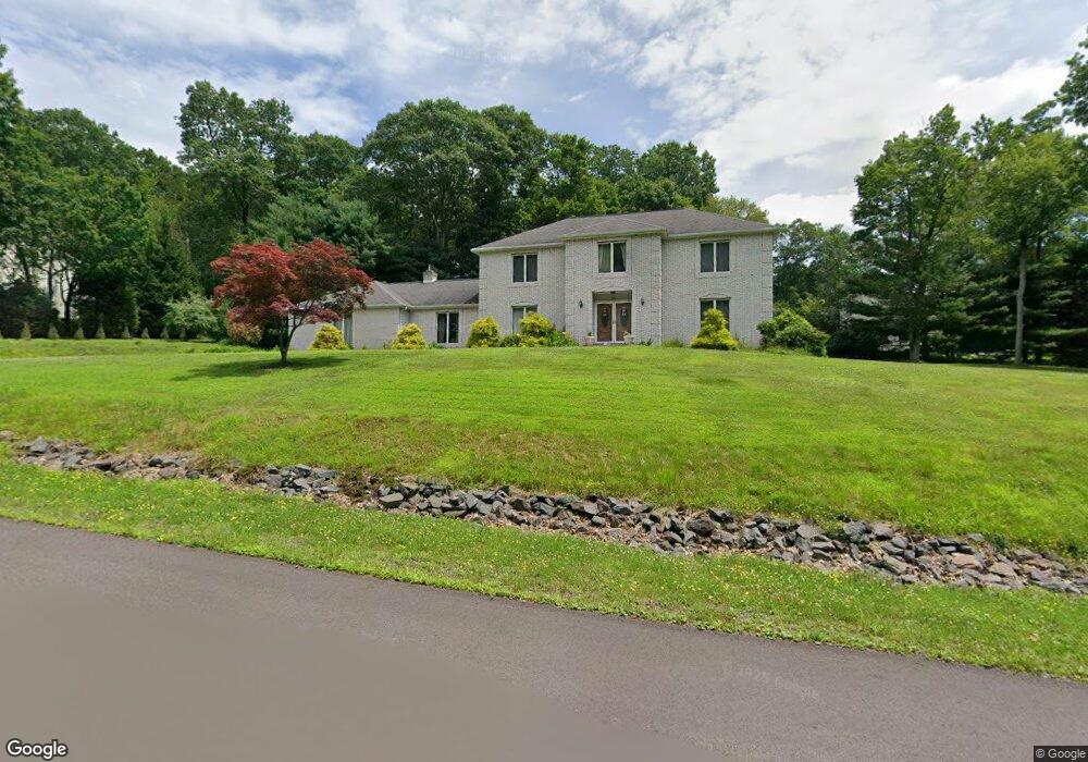
46 Doe Run Trail Mountain Top, PA 18707
Estimated Value: $504,000 - $591,000
3
Beds
5
Baths
3,160
Sq Ft
$170/Sq Ft
Est. Value
About This Home
This home is located at 46 Doe Run Trail, Mountain Top, PA 18707 and is currently estimated at $536,743, approximately $169 per square foot. 46 Doe Run Trail is a home located in Luzerne County with nearby schools including Crestwood Secondary Campus (Crestwood High School) and St Jude School.
Ownership History
Date
Name
Owned For
Owner Type
Purchase Details
Closed on
Jul 12, 2013
Sold by
Glodawa Jan and Glodawa Maria
Bought by
Beers Alfred Bishop and Beers Laura
Current Estimated Value
Home Financials for this Owner
Home Financials are based on the most recent Mortgage that was taken out on this home.
Original Mortgage
$245,600
Outstanding Balance
$178,587
Interest Rate
3.92%
Mortgage Type
New Conventional
Estimated Equity
$358,156
Create a Home Valuation Report for This Property
The Home Valuation Report is an in-depth analysis detailing your home's value as well as a comparison with similar homes in the area
Home Values in the Area
Average Home Value in this Area
Purchase History
| Date | Buyer | Sale Price | Title Company |
|---|---|---|---|
| Beers Alfred Bishop | $307,000 | None Available |
Source: Public Records
Mortgage History
| Date | Status | Borrower | Loan Amount |
|---|---|---|---|
| Open | Beers Alfred Bishop | $245,600 |
Source: Public Records
Tax History Compared to Growth
Tax History
| Year | Tax Paid | Tax Assessment Tax Assessment Total Assessment is a certain percentage of the fair market value that is determined by local assessors to be the total taxable value of land and additions on the property. | Land | Improvement |
|---|---|---|---|---|
| 2025 | $6,255 | $308,200 | $70,000 | $238,200 |
| 2024 | $6,178 | $308,200 | $70,000 | $238,200 |
| 2023 | $5,980 | $308,200 | $70,000 | $238,200 |
| 2022 | $5,831 | $308,200 | $70,000 | $238,200 |
| 2021 | $5,702 | $308,200 | $70,000 | $238,200 |
| 2020 | $5,616 | $308,200 | $70,000 | $238,200 |
| 2019 | $5,275 | $308,200 | $70,000 | $238,200 |
| 2018 | $6,050 | $365,000 | $70,000 | $295,000 |
| 2017 | $6,050 | $365,000 | $70,000 | $295,000 |
| 2016 | -- | $365,000 | $70,000 | $295,000 |
| 2015 | $5,405 | $365,000 | $70,000 | $295,000 |
| 2014 | $5,405 | $365,000 | $70,000 | $295,000 |
Source: Public Records
Map
Nearby Homes
- 383 S Main Rd
- 411 S Main Rd
- 330 Deer Run Dr
- 1133 S Main Rd
- 243 Church Rd
- 23 Olivia Way
- 25-73 Olivia Way
- 25 Olivia Way
- 29 Olivia Way
- Breckenridge Plan at Hillcrest Estates at Mountain Top
- Folino Plan at Hillcrest Estates at Mountain Top
- Birchwood Plan at Hillcrest Estates at Mountain Top
- Lily Plan at Hillcrest Estates at Mountain Top
- Franklyn Plan at Hillcrest Estates at Mountain Top
- Pinehurst Plan at Hillcrest Estates at Mountain Top
- Nittany Plan at Hillcrest Estates at Mountain Top
- Morgan Plan at Hillcrest Estates at Mountain Top
- Mia Plan at Hillcrest Estates at Mountain Top
- Madison Plan at Hillcrest Estates at Mountain Top
- 117 Scarlet Rd
- 128 White Tail Dr
- 120 White Tail Dr
- 42 Doe Run Trail
- 49 Doe Run Trail
- 130 White Tail Dr
- 125 White Tail Dr
- 129 White Tail Dr
- 116 White Tail Dr
- 121 White Tail Dr
- 38 Doe Run Trail
- 45 Doe Run Trail
- 133 White Tail Dr
- 227 Deer Run Dr
- 223 Deer Run Dr
- 243 Deer Run Dr
- 34 Doe Run Trail
- 112 White Tail Dr
- 76 Deer Run Dr
- 5 Fawn Ct
- 41 Doe Run Trail