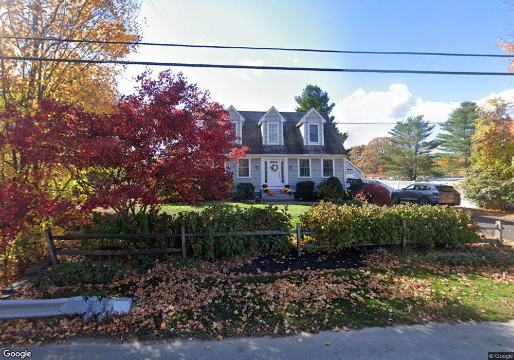
46 Fern Ave Amesbury, MA 01913
Estimated Value: $731,000 - $829,000
3
Beds
3
Baths
1,756
Sq Ft
$442/Sq Ft
Est. Value
About This Home
This home is located at 46 Fern Ave, Amesbury, MA 01913 and is currently estimated at $775,462, approximately $441 per square foot. 46 Fern Ave is a home located in Essex County with nearby schools including Amesbury High School and Amesbury Seventh-Day Adventist School.
Ownership History
Date
Name
Owned For
Owner Type
Purchase Details
Closed on
Apr 11, 2016
Sold by
Coogan Jane M and Coogan Christopher R
Bought by
Girouard Scott G and Girouard Natalie H
Current Estimated Value
Home Financials for this Owner
Home Financials are based on the most recent Mortgage that was taken out on this home.
Original Mortgage
$386,000
Interest Rate
3.62%
Mortgage Type
New Conventional
Purchase Details
Closed on
Aug 31, 2009
Sold by
Surette Kenneth
Bought by
Coogan Jane M
Home Financials for this Owner
Home Financials are based on the most recent Mortgage that was taken out on this home.
Original Mortgage
$378,026
Interest Rate
5.17%
Mortgage Type
Purchase Money Mortgage
Purchase Details
Closed on
Aug 8, 2008
Sold by
Marquis Donna L
Bought by
Surette Kenneth
Home Financials for this Owner
Home Financials are based on the most recent Mortgage that was taken out on this home.
Original Mortgage
$285,000
Interest Rate
6.49%
Mortgage Type
Purchase Money Mortgage
Create a Home Valuation Report for This Property
The Home Valuation Report is an in-depth analysis detailing your home's value as well as a comparison with similar homes in the area
Home Values in the Area
Average Home Value in this Area
Purchase History
| Date | Buyer | Sale Price | Title Company |
|---|---|---|---|
| Girouard Scott G | $416,000 | -- | |
| Coogan Jane M | $385,000 | -- | |
| Surette Kenneth | $50,000 | -- |
Source: Public Records
Mortgage History
| Date | Status | Borrower | Loan Amount |
|---|---|---|---|
| Closed | Girouard Scott G | $386,000 | |
| Previous Owner | Surette Kenneth | $379,347 | |
| Previous Owner | Surette Kenneth | $378,026 | |
| Previous Owner | Surette Kenneth | $285,000 |
Source: Public Records
Tax History Compared to Growth
Tax History
| Year | Tax Paid | Tax Assessment Tax Assessment Total Assessment is a certain percentage of the fair market value that is determined by local assessors to be the total taxable value of land and additions on the property. | Land | Improvement |
|---|---|---|---|---|
| 2025 | $9,977 | $652,100 | $248,700 | $403,400 |
| 2024 | $9,978 | $638,000 | $234,600 | $403,400 |
| 2023 | $9,013 | $551,600 | $204,000 | $347,600 |
| 2022 | $8,256 | $466,700 | $177,400 | $289,300 |
| 2021 | $7,629 | $418,000 | $136,900 | $281,100 |
| 2020 | $6,915 | $402,500 | $131,600 | $270,900 |
| 2019 | $6,913 | $376,300 | $131,600 | $244,700 |
| 2018 | $6,983 | $367,700 | $125,300 | $242,400 |
| 2017 | $6,725 | $337,100 | $125,300 | $211,800 |
| 2016 | $6,652 | $328,000 | $125,300 | $202,700 |
| 2015 | $6,616 | $322,100 | $125,300 | $196,800 |
| 2014 | $6,092 | $290,500 | $125,300 | $165,200 |
Source: Public Records
Map
Nearby Homes
- 1 Stacey Ln
- 1 Brown Ave Unit 3-80
- 3 Brown Ave Unit 75
- 57 Clinton St
- 3 Glenwood St
- 25 Whittier Meadows Dr
- 2 Locke Hill Ln
- 21 Woodman Rd
- 100 Congress St
- 105 Market St Unit B
- 103 Market St Unit A
- 103 Market St Unit B
- 101 Market St Unit B
- 101 Market St Unit A
- 7 Melrose St
- 25 Cedar St Unit 4
- 25 Cedar St Unit 7
- 48 Orchard St
- 97 Elm St
- 53 Market St