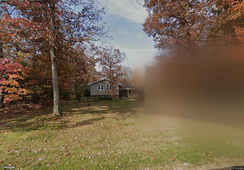
460 Miller Rd Franklin, PA 16323
Estimated Value: $220,000 - $304,000
3
Beds
2
Baths
1,542
Sq Ft
$170/Sq Ft
Est. Value
About This Home
This home is located at 460 Miller Rd, Franklin, PA 16323 and is currently estimated at $262,088, approximately $169 per square foot. 460 Miller Rd is a home located in Venango County with nearby schools including Franklin Area High School.
Ownership History
Date
Name
Owned For
Owner Type
Purchase Details
Closed on
Apr 24, 2024
Sold by
Ramfos Family Trust and Ramfos Ryan J
Bought by
Benson Levi C and Benson Danielle M
Current Estimated Value
Home Financials for this Owner
Home Financials are based on the most recent Mortgage that was taken out on this home.
Original Mortgage
$160,000
Outstanding Balance
$154,446
Interest Rate
6.87%
Mortgage Type
New Conventional
Estimated Equity
$107,642
Purchase Details
Closed on
Jul 3, 2019
Sold by
Ramfos Leonard J and Ramfos Karen A
Bought by
Ramfos Leonard J and Ramfos Leonard J
Purchase Details
Closed on
Jun 1, 2006
Sold by
Richey Lee M and Richey Margaret J
Bought by
Ramfos Leonard J and Ramfos Karen A
Home Financials for this Owner
Home Financials are based on the most recent Mortgage that was taken out on this home.
Original Mortgage
$65,000
Interest Rate
6.55%
Create a Home Valuation Report for This Property
The Home Valuation Report is an in-depth analysis detailing your home's value as well as a comparison with similar homes in the area
Home Values in the Area
Average Home Value in this Area
Purchase History
| Date | Buyer | Sale Price | Title Company |
|---|---|---|---|
| Benson Levi C | $200,000 | Brokers Settlement Services | |
| Ramfos Leonard J | -- | None Available | |
| Ramfos Leonard J | $149,000 | None Available |
Source: Public Records
Mortgage History
| Date | Status | Borrower | Loan Amount |
|---|---|---|---|
| Open | Benson Levi C | $160,000 | |
| Previous Owner | Ramfos Leonard J | $65,000 |
Source: Public Records
Tax History Compared to Growth
Tax History
| Year | Tax Paid | Tax Assessment Tax Assessment Total Assessment is a certain percentage of the fair market value that is determined by local assessors to be the total taxable value of land and additions on the property. | Land | Improvement |
|---|---|---|---|---|
| 2025 | $2,511 | $95,510 | $15,400 | $80,110 |
| 2024 | $2,463 | $95,510 | $15,400 | $80,110 |
| 2023 | $2,463 | $95,510 | $15,400 | $80,110 |
| 2022 | $2,463 | $95,510 | $15,400 | $80,110 |
| 2021 | $2,463 | $95,510 | $15,400 | $80,110 |
| 2020 | $2,463 | $95,510 | $15,400 | $80,110 |
| 2019 | $2,463 | $95,510 | $15,400 | $80,110 |
| 2018 | $2,463 | $95,510 | $15,400 | $80,110 |
| 2017 | -- | $95,510 | $15,400 | $80,110 |
| 2016 | $2,405 | $95,510 | $15,400 | $80,110 |
| 2015 | -- | $95,510 | $15,400 | $80,110 |
| 2014 | -- | $95,510 | $15,400 | $80,110 |
Source: Public Records
Map
Nearby Homes
- 1561 Pittsburgh Rd
- 0 Congress Hill Rd
- 00 Congress Hill Rd
- 1420 Pittsburgh Rd
- 415 Moreland Dr
- 1232 15th St
- 0 Doerr Rd
- 192 Evergreen Dr
- 1219 15th St
- 0 Evergreen Dr
- 922 Polk Cutoff
- 1027 Mercer Rd
- 645 Forest Ln
- 299 Evergreen Dr
- 345 S Penn Rd
- 309 4th St
- 365 S Penn Rd
- 295 Rosemont Farm Rd
- 607 Liberty St
- 0 Overlook Dr