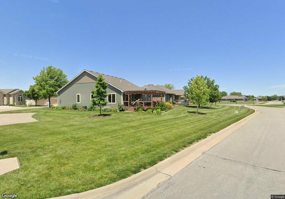
4604 SW Crenshaw Dr Topeka, KS 66610
Estimated Value: $328,854 - $375,000
3
Beds
2
Baths
1,926
Sq Ft
$185/Sq Ft
Est. Value
About This Home
This home is located at 4604 SW Crenshaw Dr, Topeka, KS 66610 and is currently estimated at $355,714, approximately $184 per square foot. 4604 SW Crenshaw Dr is a home located in Shawnee County with nearby schools including Pauline Central Primary School, Pauline South Intermediate School, and Washburn Rural Middle School.
Ownership History
Date
Name
Owned For
Owner Type
Purchase Details
Closed on
Jan 11, 2021
Sold by
Kelly Beth S
Bought by
Kelly Beth S and Beth S Kelly Rev Tr
Current Estimated Value
Create a Home Valuation Report for This Property
The Home Valuation Report is an in-depth analysis detailing your home's value as well as a comparison with similar homes in the area
Home Values in the Area
Average Home Value in this Area
Purchase History
| Date | Buyer | Sale Price | Title Company |
|---|---|---|---|
| Kelly Beth S | -- | None Available |
Source: Public Records
Tax History Compared to Growth
Tax History
| Year | Tax Paid | Tax Assessment Tax Assessment Total Assessment is a certain percentage of the fair market value that is determined by local assessors to be the total taxable value of land and additions on the property. | Land | Improvement |
|---|---|---|---|---|
| 2025 | $5,428 | $35,633 | -- | -- |
| 2023 | $5,428 | $33,917 | $0 | $0 |
| 2022 | $4,910 | $30,556 | $0 | $0 |
| 2021 | $4,438 | $27,736 | $0 | $0 |
| 2020 | $4,184 | $26,669 | $0 | $0 |
| 2019 | $4,067 | $25,892 | $0 | $0 |
| 2018 | $3,936 | $25,138 | $0 | $0 |
| 2017 | $3,904 | $24,645 | $0 | $0 |
| 2014 | $3,949 | $24,645 | $0 | $0 |
Source: Public Records
Map
Nearby Homes
- 4419 SW Stone Ave
- 4329 SW Cambridge Ave
- 3313 SW 46th St
- 4313 SW Stone Ave
- 4406 SW Lakeside Dr
- 3334 SW 43rd St
- 4334 SW Lakeside Dr
- 4229 SW Cambridge Ave
- 3817 SW Wood Valley Dr
- 3724 SW Brook Lawn Cir
- 3746 SW Wood Valley Dr
- 3903 SW Burlingame Rd
- 4498 SW Moundview Dr
- XXXX SW Moundview Dr
- 5515 SW Mission Ave
- 3638 SW Willow Brook Ct
- 2920 SW Twilight Dr
- 3600 SW Randolph Square Unit 40
- 3572 SW Willow Brook Dr
- 3751 SW Summerfield Dr
- 4600 SW Crenshaw Dr
- 4608 SW Crenshaw Dr
- 4542 SW Crenshaw Dr
- 4538 SW Crenshaw Dr
- 4605 SW Crenshaw Dr
- 4601 SW Crenshaw Dr
- 4609 SW Crenshaw Dr
- 4543 SW Crenshaw Dr
- 4617 SW Crenshaw Dr
- 4613 SW Crenshaw Dr
- 4608 SW Cambridge Ave
- 4539 SW Crenshaw Dr
- 4544 SW Woods Dr
- 4614 SW Cambridge Ave
- 4535 SW Crenshaw Dr
- Blk A Lot 1 SW Crenshaw Dr Unit Plot 21 - Berkshire
- Blk A Lot 1 SW Crenshaw Dr Unit Plot 21
- Blk C Lot 18 SW Crenshaw Dr
- Blk A Lot 1 SW Crenshaw Dr Unit Plot 21, Berkshire V
- Blk A Lot 1 SW Crenshaw Dr Unit Plot 10, Berkshire V