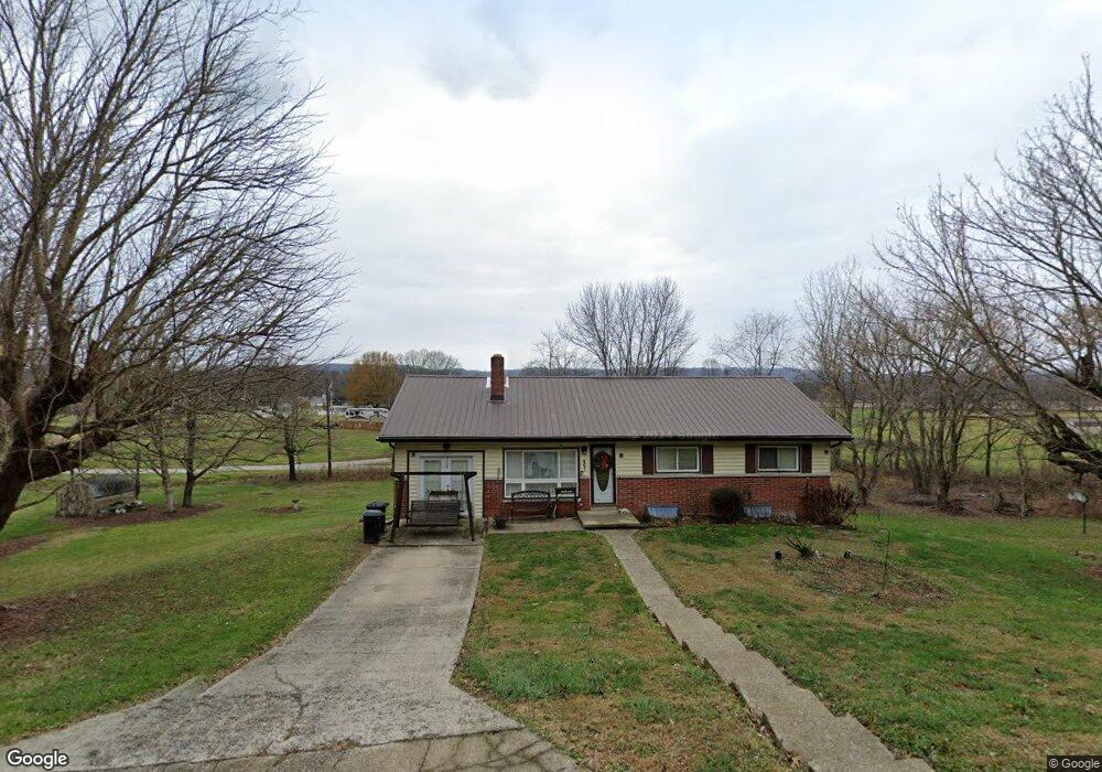
461 Back Rd Ironton, OH 45638
Estimated Value: $132,931 - $167,000
4
Beds
2
Baths
1,080
Sq Ft
$137/Sq Ft
Est. Value
About This Home
This home is located at 461 Back Rd, Ironton, OH 45638 and is currently estimated at $147,483, approximately $136 per square foot. 461 Back Rd is a home located in Scioto County with nearby schools including Green Elementary School and Green High School.
Ownership History
Date
Name
Owned For
Owner Type
Purchase Details
Closed on
Sep 7, 2018
Sold by
Gustin William Dennis
Bought by
Otworth Keith and Otworth Freida
Current Estimated Value
Purchase Details
Closed on
Nov 5, 2010
Sold by
Singleton Veatrice O
Bought by
Singleton Michelle
Purchase Details
Closed on
Jun 13, 2006
Sold by
Michelle Michelle
Bought by
Singleton Michelle and Singleton Veatrice O
Purchase Details
Closed on
Jan 11, 2006
Sold by
Evans Jason M and Evans
Bought by
Singleton Michelle L
Purchase Details
Closed on
Feb 4, 2004
Sold by
Willis Donald R+Shirley F
Bought by
Evans Jason M
Create a Home Valuation Report for This Property
The Home Valuation Report is an in-depth analysis detailing your home's value as well as a comparison with similar homes in the area
Purchase History
| Date | Buyer | Sale Price | Title Company |
|---|---|---|---|
| Otworth Keith | $85,000 | None Available | |
| Singleton Michelle | -- | -- | |
| Singleton Michelle | -- | -- | |
| Singleton Michelle L | $89,900 | -- | |
| Evans Jason M | $79,900 | -- |
Source: Public Records
Tax History
| Year | Tax Paid | Tax Assessment Tax Assessment Total Assessment is a certain percentage of the fair market value that is determined by local assessors to be the total taxable value of land and additions on the property. | Land | Improvement |
|---|---|---|---|---|
| 2025 | $1,486 | $37,350 | $5,610 | $31,740 |
| 2024 | $1,486 | $29,290 | $4,880 | $24,410 |
| 2023 | $1,535 | $29,290 | $4,880 | $24,410 |
| 2022 | $1,404 | $29,290 | $4,880 | $24,410 |
| 2021 | $1,150 | $24,140 | $4,320 | $19,820 |
| 2020 | $1,151 | $24,140 | $4,320 | $19,820 |
| 2019 | $1,141 | $22,600 | $3,900 | $18,700 |
| 2018 | $1,091 | $22,600 | $3,900 | $18,700 |
| 2017 | $898 | $22,600 | $3,900 | $18,700 |
| 2016 | $1,022 | $22,680 | $3,620 | $19,060 |
| 2015 | $1,022 | $21,070 | $3,620 | $17,450 |
| 2013 | $873 | $21,070 | $3,620 | $17,450 |
Source: Public Records
Map
Nearby Homes
- 0 Private Drive 411
- 0 Disterdick Ln Unit 153942
- 1802 Main St
- 1516 Gallia Pike
- 1201 Walnut St
- 11593 U S 23 Hwy
- 3365 St Rt 827
- 00 Us 23 & Preston Ave
- 000 Seaton Ave
- 219 Main St
- 40 Griffith Ct
- 42 Griffith Ct
- 537 Laurel St
- 529 Laurel St
- 404 Sycamore St
- 608 Wurtland Ave
- 612 Fulton Ave
- 2775 Gallia Pike
- 0 Whetstone Rd
- 58 Private Drive 4037
Your Personal Tour Guide
Ask me questions while you tour the home.