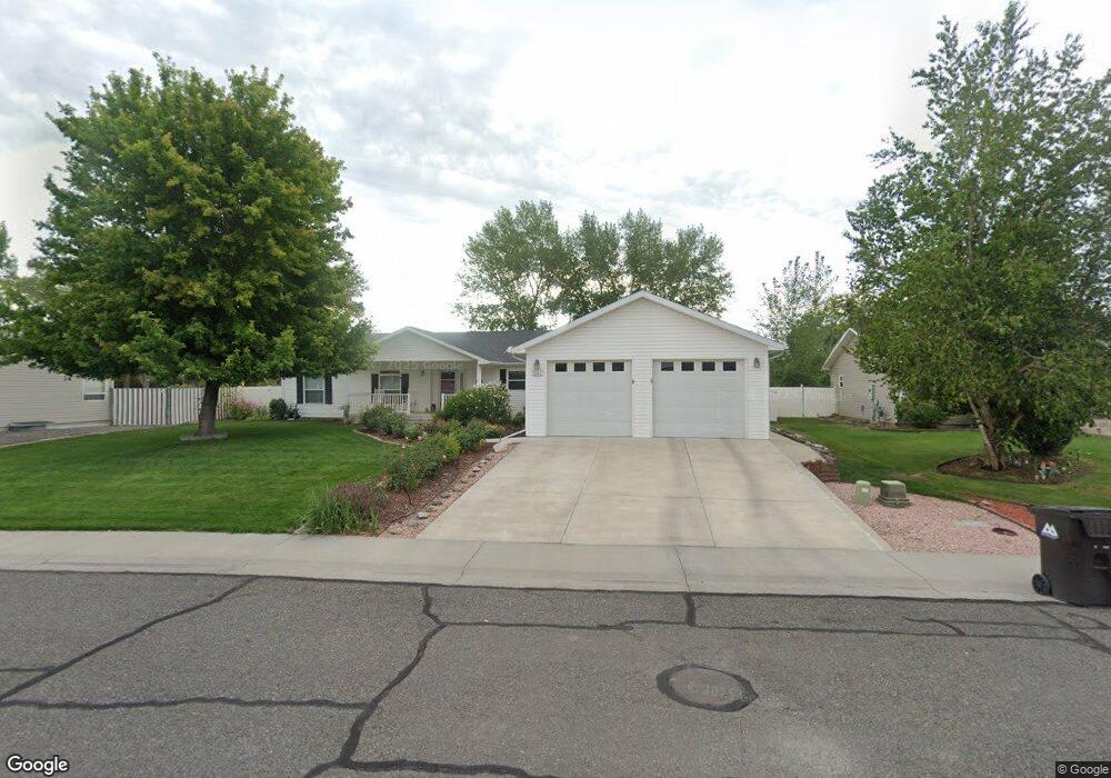
461 Silver Dr Montrose, CO 81401
Estimated Value: $396,194 - $494,000
3
Beds
2
Baths
2,173
Sq Ft
$203/Sq Ft
Est. Value
About This Home
This home is located at 461 Silver Dr, Montrose, CO 81401 and is currently estimated at $441,299, approximately $203 per square foot. 461 Silver Dr is a home located in Montrose County with nearby schools including Johnson Elementary School, Centennial Middle School, and Montrose High School.
Ownership History
Date
Name
Owned For
Owner Type
Purchase Details
Closed on
Oct 11, 2022
Sold by
Hopkins Gary L and Hopkins Glenna E
Bought by
Hopkins Gary L and Hopkins Glenna E
Current Estimated Value
Purchase Details
Closed on
Feb 27, 2015
Sold by
Moore Family Trust As Amended
Bought by
Hopkins Gaty L and Hopking Glenna E Hopking
Purchase Details
Closed on
Mar 1, 2006
Sold by
Websters Town & Country Properties Llc
Bought by
Moore Paul and Moore Nancy
Purchase Details
Closed on
May 8, 2003
Sold by
Downey Excavation Inc
Bought by
Websters Town & Country Prop Llc
Purchase Details
Closed on
Nov 1, 2000
Sold by
B O K Enterprises Llc
Bought by
Downey Excavation Inc
Create a Home Valuation Report for This Property
The Home Valuation Report is an in-depth analysis detailing your home's value as well as a comparison with similar homes in the area
Home Values in the Area
Average Home Value in this Area
Purchase History
| Date | Buyer | Sale Price | Title Company |
|---|---|---|---|
| Hopkins Gary L | -- | None Listed On Document | |
| Hopkins Gaty L | $197,000 | Land Title Guarantee | |
| Moore Paul | $39,900 | None Available | |
| Websters Town & Country Prop Llc | $35,800 | -- | |
| Downey Excavation Inc | -- | -- |
Source: Public Records
Tax History Compared to Growth
Tax History
| Year | Tax Paid | Tax Assessment Tax Assessment Total Assessment is a certain percentage of the fair market value that is determined by local assessors to be the total taxable value of land and additions on the property. | Land | Improvement |
|---|---|---|---|---|
| 2024 | $1,813 | $25,160 | $3,210 | $21,950 |
| 2023 | $1,813 | $29,920 | $3,820 | $26,100 |
| 2022 | $1,623 | $23,250 | $2,780 | $20,470 |
| 2021 | $1,671 | $23,920 | $2,860 | $21,060 |
| 2020 | $1,430 | $21,040 | $2,720 | $18,320 |
| 2019 | $1,440 | $21,040 | $2,720 | $18,320 |
| 2018 | $1,172 | $16,690 | $2,200 | $14,490 |
| 2017 | $1,162 | $16,690 | $2,200 | $14,490 |
| 2016 | $1,018 | $14,860 | $2,200 | $12,660 |
| 2015 | $1,000 | $14,860 | $2,200 | $12,660 |
| 2014 | $734 | $11,650 | $2,200 | $9,450 |
Source: Public Records
Map
Nearby Homes
- 67133 Locust Rd
- 761 Silver Dr
- 13547 6700 Rd
- 2965 Locust Rd
- 13721 6700 Rd
- 13.33 Acres Highway 50
- TBD Highway 50 Iron Horse Dr
- 2091 Locust Rd
- 665 6600 Rd
- 381 6600 Rd
- TBD 6600 Rd
- 67250 Locust Rd Unit 21
- 12858 6700 Rd
- 133 Castle Ave
- 1809 Draft Horse Rd
- 1806 Galaxy Dr
- 1808 Moonlight Dr
- 66231 Landfill Rd
- 1730 Moonlight Dr
- 1710 Galaxy Dr
- 451 Silver Dr
- 471 Silver Dr
- 441 Silver Dr
- 462 Silver Dr
- 0 Silver Dr Unit 768091
- 0 Silver Dr Unit 768120
- 0 Silver Dr Unit 761386
- 0 Silver Dr Unit 753536
- 0 Silver Dr Unit 751676
- 0 Silver Dr Unit 747331
- 0 Silver Dr Unit 743075
- 0 Silver Dr Unit 739940
- 0 Silver Dr Unit 690210
- 0 Silver Dr Unit 703247
- 0 Silver Dr Unit 717416
- 0 Silver Dr Unit 731568
- 0 Silver Dr Unit 596567
- 0 Silver Dr Unit 597866
- 0 Silver Dr Unit 610942
- 0 Silver Dr Unit 612217