J
Seller's Agent in 2026
James Wangelin
eXp Realty
(716) 903-3198
5 in this area
172 Total Sales
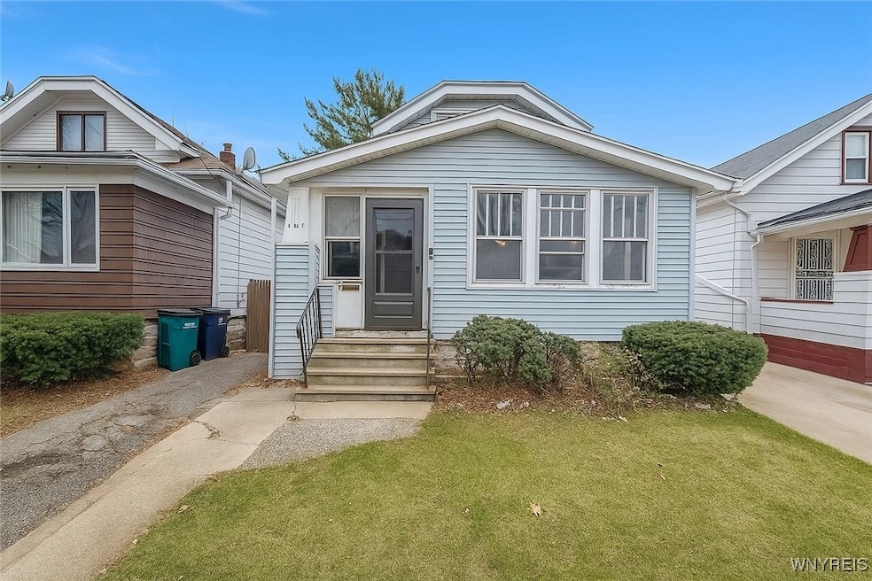


This home is located at 461 Stockbridge Ave, Buffalo, NY 14215 and is currently priced at $96,500, approximately $72 per square foot. This property was built in 1925. 461 Stockbridge Ave is a home located in Erie County with nearby schools including Westminster Community Charter School, Charter School Of Inquiry, and Buffalo United Charter School.
Last Agent to Sell the Property
Listing by eXp Realty Brokerage Phone: 716-903-3198 License #10301224073 Listed on: 11/18/2025

Co-Listed By
Listing by eXp Realty Brokerage Phone: 716-903-3198 License #10301217624
| Date | Type | Sale Price | Title Company |
|---|---|---|---|
| Warranty Deed | $96,500 | None Available | |
| Warranty Deed | -- | None Available | |
| Warranty Deed | $340,000 | None Available | |
| Deed | $39,900 | -- |
| Date | Status | Loan Amount | Loan Type |
|---|---|---|---|
| Previous Owner | $17,500 | New Conventional |
| Date | Event | Price | List to Sale | Price per Sq Ft |
|---|---|---|---|---|
| 02/27/2026 02/27/26 | Sold | $96,500 | -19.5% | $72 / Sq Ft |
| 12/07/2025 12/07/25 | Pending | -- | -- | -- |
| 12/01/2025 12/01/25 | Price Changed | $119,900 | -4.0% | $90 / Sq Ft |
| 11/18/2025 11/18/25 | For Sale | $124,900 | -- | $93 / Sq Ft |
| Year | Tax Paid | Tax Assessment Tax Assessment Total Assessment is a certain percentage of the fair market value that is determined by local assessors to be the total taxable value of land and additions on the property. | Land | Improvement |
|---|---|---|---|---|
| 2024 | $247 | $44,000 | $4,200 | $39,800 |
| 2023 | $223 | $44,000 | $4,200 | $39,800 |
| 2022 | $221 | $44,000 | $4,200 | $39,800 |
| 2021 | $221 | $44,000 | $4,200 | $39,800 |
| 2020 | $307 | $44,000 | $4,200 | $39,800 |
| 2019 | $1,095 | $39,900 | $4,300 | $35,600 |
| 2018 | $1,030 | $39,900 | $4,300 | $35,600 |
| 2017 | $237 | $39,900 | $4,300 | $35,600 |
| 2016 | $971 | $39,900 | $4,300 | $35,600 |
| 2015 | -- | $39,900 | $4,300 | $35,600 |
| 2014 | -- | $39,900 | $4,300 | $35,600 |
J
Seller's Agent in 2026
James Wangelin
eXp Realty
(716) 903-3198
5 in this area
172 Total Sales
Seller Co-Listing Agent in 2026
Marcy Dexheimer
eXp Realty
(716) 940-2591
2 in this area
235 Total Sales
Buyer's Agent in 2026
Pushpa Gunatilake
Pioneer Star Real Estate Inc.
(716) 907-3046
36 in this area
348 Total Sales
Source: Western New York Real Estate Information Services (WNYREIS)
MLS Number: B1651351
APN: 140200-079-810-0006-016-000
Disclaimer: Certain information contained herein is derived from information provided by parties other than Homes.com. All information provided is deemed reliable, but is not guaranteed to be accurate and should be independently verified.
![]() The data relating to real estate on this web site comes in part from the Internet Data Exchange (IDX) Program of the CNYIS, UNYREIS and WNYREIS. Real estate listings held by firms other than Homes.com, LLC are marked with the IDX logo and include the Listing Broker’s Firm Name.
The data relating to real estate on this web site comes in part from the Internet Data Exchange (IDX) Program of the CNYIS, UNYREIS and WNYREIS. Real estate listings held by firms other than Homes.com, LLC are marked with the IDX logo and include the Listing Broker’s Firm Name.
Disclaimer: All information deemed reliable but not guaranteed and should be independently verified. All properties
are subject to prior sale, change or withdrawal. Neither the listing broker(s) nor Homes.com, LLC shall be responsible for any typographical errors, misinformation, misprints, and shall be held totally harmless.
© 2026 CNYIS, UNYREIS, WNYREIS. All rights reserved.
Ask me questions while you tour the home.