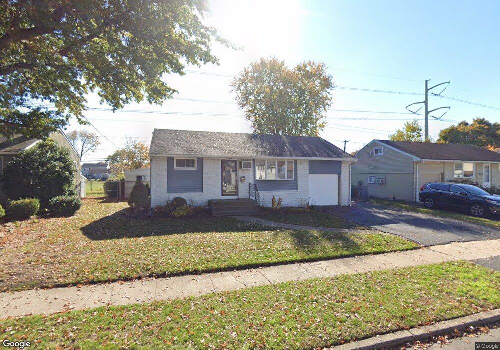
4612 Brookside Ave Bristol, PA 19007
Estimated Value: $254,000 - $339,000
3
Beds
1
Bath
830
Sq Ft
$363/Sq Ft
Est. Value
About This Home
This home is located at 4612 Brookside Ave, Bristol, PA 19007 and is currently estimated at $301,308, approximately $363 per square foot. 4612 Brookside Ave is a home located in Bucks County with nearby schools including Truman Senior High School, First Presbyterian Church School, and Isabet Academy.
Ownership History
Date
Name
Owned For
Owner Type
Purchase Details
Closed on
Nov 16, 2015
Sold by
Estate Of Helen M Gerth and Dougherty Nancy
Bought by
Lyons Paige and Gerth Brian
Current Estimated Value
Home Financials for this Owner
Home Financials are based on the most recent Mortgage that was taken out on this home.
Original Mortgage
$121,250
Outstanding Balance
$95,369
Interest Rate
3.79%
Mortgage Type
New Conventional
Estimated Equity
$205,939
Purchase Details
Closed on
Sep 13, 1983
Sold by
Usa Veterans Affairs
Bought by
Gerth William and Gerth Helen M
Create a Home Valuation Report for This Property
The Home Valuation Report is an in-depth analysis detailing your home's value as well as a comparison with similar homes in the area
Home Values in the Area
Average Home Value in this Area
Purchase History
| Date | Buyer | Sale Price | Title Company |
|---|---|---|---|
| Lyons Paige | $125,000 | First American Title Ins Co | |
| Gerth William | $10,600 | -- |
Source: Public Records
Mortgage History
| Date | Status | Borrower | Loan Amount |
|---|---|---|---|
| Open | Lyons Paige | $121,250 |
Source: Public Records
Tax History Compared to Growth
Tax History
| Year | Tax Paid | Tax Assessment Tax Assessment Total Assessment is a certain percentage of the fair market value that is determined by local assessors to be the total taxable value of land and additions on the property. | Land | Improvement |
|---|---|---|---|---|
| 2025 | $3,911 | $14,400 | $4,320 | $10,080 |
| 2024 | $3,911 | $14,400 | $4,320 | $10,080 |
| 2023 | $3,882 | $14,400 | $4,320 | $10,080 |
| 2022 | $3,882 | $14,400 | $4,320 | $10,080 |
| 2021 | $3,882 | $14,400 | $4,320 | $10,080 |
| 2020 | $3,882 | $14,400 | $4,320 | $10,080 |
| 2019 | $3,867 | $14,400 | $4,320 | $10,080 |
| 2018 | $3,805 | $14,400 | $4,320 | $10,080 |
| 2017 | $3,747 | $14,400 | $4,320 | $10,080 |
| 2016 | $3,747 | $14,400 | $4,320 | $10,080 |
| 2015 | $2,632 | $14,400 | $4,320 | $10,080 |
| 2014 | $2,632 | $14,400 | $4,320 | $10,080 |
Source: Public Records
Map
Nearby Homes
- 2519 Woodlawn Dr
- 2715 Crest Ave
- 3021 Bath Rd
- 2 Michele Ct
- 238 Colette Ct Unit 1311
- 35 Beechtree Rd
- 145 Mill Dr
- 23 Misty Pine Rd
- 34 Misty Pine Rd
- 185 Delhaas Cir
- 183 Delhaas Cir
- 187 Delhaas Cir
- 194 Delhaas Cir
- 189 Delhaas Cir
- 2416 Fleetwing Dr
- 131 Delhaas Cir
- 129 Delhaas Cir
- 127 Delhaas Cir
- 134 Delhaas Cir
- 124 Delhaas Cir
- 4614 Brookside Ave
- 4610 Brookside Ave
- 4616 Brookside Ave
- 4608 Brookside Ave
- 4611 Brookside Ave
- 4609 Brookside Ave
- 4613 Brookside Ave
- 2500 Green Ave
- 4618 Brookside Ave
- 4606 Brookside Ave
- 4615 Brookside Ave
- 2502 Green Ave
- 2501 Winton Dr
- 2505 Winton Dr
- 2503 Winton Dr
- 4700 Brookside Ave
- 2501 Green Ave
- 2504 Green Ave
- 2507 Winton Dr
- 4604 Brookside Ave